National Register of Historic Places listings in Miami County, Indiana

Last updated

Location of Miami County in Indiana Map of Indiana highlighting Miami County.svg
Location of Miami County in Indiana

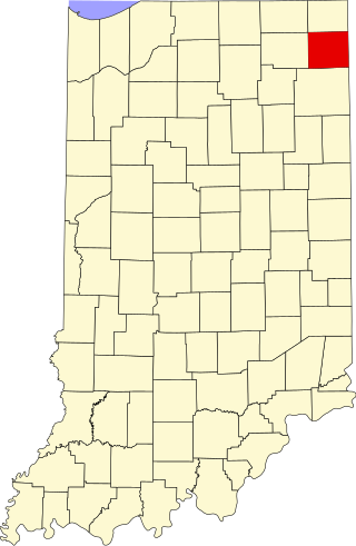
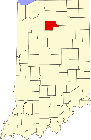
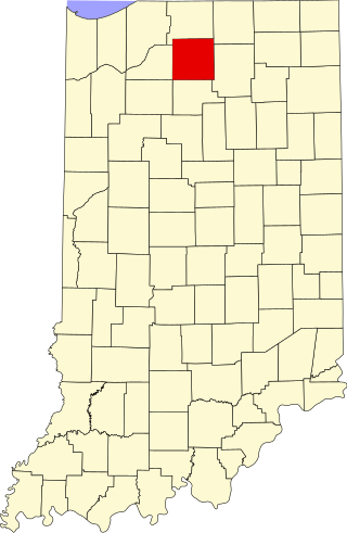
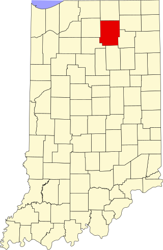
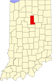
This is a list of the National Register of Historic Places listings in Miami County, Indiana.

Contents

This is intended to be a complete list of the properties on the National Register of Historic Places in Miami County, Indiana, United States. Latitude and longitude coordinates are provided for many National Register properties; these locations may be seen together in a map. [1]

There are 17 properties listed on the National Register in the county, including 1 National Historic Landmark. One property was listed, but has since been removed.

Properties and districts located in incorporated areas display the name of the municipality, while properties and districts in unincorporated areas display the name of their civil township. Properties and districts split between multiple jurisdictions display the names of all jurisdictions.


    This National Park Service list is complete through NPS recent listings posted September 1, 2023. [2]

Map all coordinates using: OpenStreetMap

Current listings

[3] Name on the Register [4] ImageDate listed [5] Location City or townDescription
1 B-17G "Flying Fortress" No. 44-83690
B-17G "Flying Fortress" No. 44-83690 Grissom Air Museum B-17G "Flying Fortress" No. 44-83690 P9270540.jpg
B-17G "Flying Fortress" No. 44-83690
June 29, 1993
(#93000540)
Heritage Museum Foundation, off U.S. Route 31 at Grissom Air Force Base
40°40′06″N86°07′46″W / 40.668333°N 86.129444°W / 40.668333; -86.129444 (B-17G "Flying Fortress" No. 44-83690)
Pipe Creek Township
2 Brownell Block/Senger Dry Goods Company Building
Brownell Block/Senger Dry Goods Company Building Brownell Block-Senger Dry Goods Company Building.jpg
Brownell Block/Senger Dry Goods Company Building
September 1, 1983
(#83000007)
Broadway and 5th Sts.
40°45′18″N86°04′10″W / 40.755°N 86.069444°W / 40.755; -86.069444 (Brownell Block/Senger Dry Goods Company Building)
Peru
3 James Omar Cole House
James Omar Cole House James Omar Cole House.jpg
James Omar Cole House
March 1, 1984
(#84001198)
27 E. 3rd St.
40°45′12″N86°04′00″W / 40.753333°N 86.066667°W / 40.753333; -86.066667 (James Omar Cole House)
Peru
4 Converse Commercial Historic District
Converse Commercial Historic District Wabash and Jefferson, Converse.jpg
Converse Commercial Historic District
December 27, 2016
(#16000907)
4 blocks along Jefferson between Marion and 1st Sts., and 1 block of E. Railroad St.
40°34′45″N85°52′24″W / 40.579193°N 85.873319°W / 40.579193; -85.873319 (Converse Commercial Historic District)
Converse
5 Converse Depot
Converse Depot Converse Depot exterior.jpg
Converse Depot
March 3, 1995
(#95000205)
203 E. Railroad St.
40°34′49″N85°52′14″W / 40.580278°N 85.870556°W / 40.580278; -85.870556 (Converse Depot)
Converse
6 Converse-Jackson Township Public Library
Converse-Jackson Township Public Library Converse-Jackson Township Public Library.jpg
Converse-Jackson Township Public Library
March 12, 1999
(#99000298)
100 S. Jefferson St.
40°34′39″N85°52′26″W / 40.5775°N 85.873889°W / 40.5775; -85.873889 (Converse-Jackson Township Public Library)
Converse
7 Eikenberry Bridge
Eikenberry Bridge Eikenberry Bridge.jpg
Eikenberry Bridge
September 20, 2006
(#06000848)
County Road 100E over the Eel River, southwest of Chili
40°51′19″N86°03′21″W / 40.855278°N 86.055833°W / 40.855278; -86.055833 (Eikenberry Bridge)
Richland Township
8 Godfroy's Addition Historic District August 30, 2023
(#100009293)
Roughly bounded by Ewing, 6th, Water, Canal, and Wabash Sts., and Clay St. between Main and 2nd Sts.
40°45′22″N86°04′00″W / 40.7560°N 86.0667°W / 40.7560; -86.0667 (Godfroy's Addition Historic District)
Peru
9 Francis Godfroy Cemetery
Francis Godfroy Cemetery Chief Francis Godfroy (Miami) Burial.jpg
Francis Godfroy Cemetery
March 1, 1984
(#84001203)
State Road 124, east of Peru
40°45′03″N85°59′35″W / 40.750833°N 85.993056°W / 40.750833; -85.993056 (Francis Godfroy Cemetery)
Butler Township
10 Terrell Jacobs Circus Winter Quarters
Terrell Jacobs Circus Winter Quarters Circus Drive-In near Peru.jpg
Terrell Jacobs Circus Winter Quarters
April 5, 2012
(#12000188)
6125 U.S. Route 31, south of Peru
40°40′36″N86°07′38″W / 40.676667°N 86.127222°W / 40.676667; -86.127222 (Terrell Jacobs Circus Winter Quarters)
Pipe Creek Township
11 Miami County Courthouse
Miami County Courthouse Peru-indiana-courthouse.jpg
Miami County Courthouse
March 19, 2008
(#08000194)
Public Square
40°45′16″N86°04′08″W / 40.754444°N 86.068889°W / 40.754444; -86.068889 (Miami County Courthouse)
Peru
12 Peru Courthouse Square Historic District
Peru Courthouse Square Historic District Peru-indiana-downtown.jpg
Peru Courthouse Square Historic District
May 23, 2018
(#100002492)
Roughly bounded by the Wabash River and Wabash, 7th, and Miami Sts.
40°45′10″N86°04′06″W / 40.752778°N 86.068333°W / 40.752778; -86.068333 (Peru Courthouse Square Historic District)
Peru
13 Peru High School Historic District
Peru High School Historic District Old Peru High School.jpg
Peru High School Historic District
January 9, 2013
(#12001154)
80 W. 6th St.
40°45′16″N86°04′24″W / 40.754444°N 86.073333°W / 40.754444; -86.073333 (Peru High School Historic District)
Peru
14 Peru Westside Historic District August 30, 2023
(#100009296)
Roughly bounded by 6th, Miami, 3rd, and Lafayette Sts.
40°45′07″N86°04′33″W / 40.7519°N 86.0758°W / 40.7519; -86.0758 (Peru Westside Historic District)
Peru
15 Shirk-Edwards House
Shirk-Edwards House Shirk-Edwards House in Peru.jpg
Shirk-Edwards House
September 14, 1995
(#95001109)
50 N. Hood St.
40°45′08″N86°04′30″W / 40.752222°N 86.075000°W / 40.752222; -86.075000 (Shirk-Edwards House)
Peru
16 Wallace Circus and American Circus Corporation Winter Quarters
Wallace Circus and American Circus Corporation Winter Quarters Wallace Circus Winter Headquarters.jpg
Wallace Circus and American Circus Corporation Winter Quarters
February 27, 1987
(#87000837)
2.5 miles (4.0 km) southeast of Peru
40°45′16″N86°01′11″W / 40.754444°N 86.019722°W / 40.754444; -86.019722 (Wallace Circus and American Circus Corporation Winter Quarters)
Butler Township
17 Westleigh Farms
Westleigh Farms Westleigh Farms barn.jpg
Westleigh Farms
September 28, 2003
(#03000976)
2107 S. Frances Slocum Trail, east of Peru
40°44′06″N86°00′18″W / 40.735°N 86.005°W / 40.735; -86.005 (Westleigh Farms)
Butler Township

Former listing

[3] Name on the RegisterImageDate listedDate removedLocationCity or townDescription
1 Paw Paw Creek Bridge No. 52
Paw Paw Creek Bridge No. 52 Paw Paw Creek Bridge No. 52 remnants.jpg
Paw Paw Creek Bridge No. 52
September 30, 1983
(#83000008)
October 13, 2015Paw Paw Pike, northeast of Chili
40°52′42″N85°57′59″W / 40.878333°N 85.966389°W / 40.878333; -85.966389 (Paw Paw Creek Bridge No. 52)
Richland Township Bridge was disassembled after a tree fell on it.

See also

Related Research Articles

<span class="mw-page-title-main">National Register of Historic Places listings in Porter County, Indiana</span>

This is a list of the National Register of Historic Places listings in Porter County, Indiana.

<span class="mw-page-title-main">National Register of Historic Places listings in DeKalb County, Indiana</span>

This is a list of the National Register of Historic Places listings in DeKalb County, Indiana.

<span class="mw-page-title-main">National Register of Historic Places listings in Wabash County, Indiana</span>

This is a list of the National Register of Historic Places listings in Wabash County, Indiana.

<span class="mw-page-title-main">National Register of Historic Places listings in Cass County, Indiana</span>

This is a list of the National Register of Historic Places listings in Cass County, Indiana.

<span class="mw-page-title-main">National Register of Historic Places listings in Floyd County, Indiana</span>

This is a list of the National Register of Historic Places listings in Floyd County, Indiana.

<span class="mw-page-title-main">National Register of Historic Places listings in White County, Indiana</span>

This is a list of the National Register of Historic Places listings in White County, Indiana.

<span class="mw-page-title-main">National Register of Historic Places listings in Clay County, Indiana</span>

This is a list of the National Register of Historic Places listings in Clay County, Indiana.

<span class="mw-page-title-main">National Register of Historic Places listings in Clinton County, Indiana</span>

This is a list of the National Register of Historic Places listings in Clinton County, Indiana.

<span class="mw-page-title-main">National Register of Historic Places listings in Franklin County, Indiana</span>

This is a list of the National Register of Historic Places listings in Franklin County, Indiana.

<span class="mw-page-title-main">National Register of Historic Places listings in Fulton County, Indiana</span>

This is a list of the National Register of Historic Places listings in Fulton County, Indiana.

<span class="mw-page-title-main">National Register of Historic Places listings in Hendricks County, Indiana</span>

This is a list of the National Register of Historic Places listings in Hendricks County, Indiana.

<span class="mw-page-title-main">National Register of Historic Places listings in Howard County, Indiana</span>

This is a list of the National Register of Historic Places listings in Howard County, Indiana.

<span class="mw-page-title-main">National Register of Historic Places listings in Jennings County, Indiana</span>

This is a list of the National Register of Historic Places listings in Jennings County, Indiana.

<span class="mw-page-title-main">National Register of Historic Places listings in Johnson County, Indiana</span>

This is a list of the National Register of Historic Places listings in Johnson County, Indiana.

<span class="mw-page-title-main">National Register of Historic Places listings in Marshall County, Indiana</span>

This is a list of the National Register of Historic Places listings in Marshall County, Indiana.

<span class="mw-page-title-main">National Register of Historic Places listings in Noble County, Indiana</span>

This is a list of the National Register of Historic Places listings in Noble County, Indiana.

<span class="mw-page-title-main">National Register of Historic Places listings in Switzerland County, Indiana</span>

This is a list of the National Register of Historic Places listings in Switzerland County, Indiana.

<span class="mw-page-title-main">National Register of Historic Places listings in Ohio County, Indiana</span>

This is a list of the National Register of Historic Places listings in Ohio County, Indiana.

<span class="mw-page-title-main">National Register of Historic Places listings in Grant County, Indiana</span>

This is a list of the National Register of Historic Places listings in Grant County, Indiana.

<span class="mw-page-title-main">National Register of Historic Places listings in Kosciusko County, Indiana</span>

This is a list of the National Register of Historic Places listings in Kosciusko County, Indiana.

References

  1. The latitude and longitude information provided in this table was derived originally from the National Register Information System, which has been found to be fairly accurate for about 99% of listings. Some locations in this table may have been corrected to current GPS standards.
  2. National Park Service, United States Department of the Interior, "National Register of Historic Places: Weekly List Actions", retrieved September 1, 2023.
  3. 1 2 Numbers represent an alphabetical ordering by significant words. Various colorings, defined here, differentiate National Historic Landmarks and historic districts from other NRHP buildings, structures, sites or objects.
  4. "National Register Information System". National Register of Historic Places . National Park Service. March 13, 2009.
  5. The eight-digit number below each date is the number assigned to each location in the National Register Information System database, which can be viewed by clicking the number.