List of Indiana state historical markers in Miami County

Last updated

Location of Miami County in Indiana Map of Indiana highlighting Miami County.svg
Location of Miami County in Indiana

This is a list of the Indiana state historical markers in Miami County.

Contents

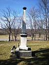
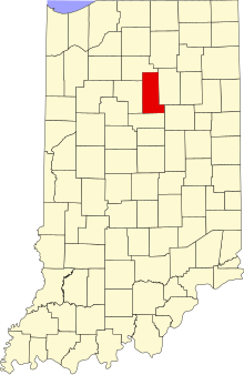
This is intended to be a complete list of the official state historical markers placed in Miami County, Indiana, United States by the Indiana Historical Bureau. The locations of the historical markers and their latitude and longitude coordinates are included below when available, along with their names, years of placement, and topics as recorded by the Historical Bureau. There are 3 historical markers located in Miami County. [1]

Historical markers

Marker titleImageYear placedLocationTopics
Burial Place of Francis Godfroy [2] Chief Francis Godfroy (Miami) Burial.jpg 1992Chief Francis Godfroy Cemetery, along State Road 124 4 miles east of Peru
40°45′4″N85°59′35″W / 40.75111°N 85.99306°W / 40.75111; -85.99306 (Burial Place of Francis Godfroy)
American Indian/Native American, Cemetery
House of Chief Richardville [3] 1992County Road 300E (Mississinewa Road), 3 miles east of Peru
40°44′52″N86°1′13″W / 40.74778°N 86.02028°W / 40.74778; -86.02028 (House of Chief Richardville)
American Indian/Native American, Buildings and Architecture, Government Institutions
Marie Stuart Edwards, 1880-1970 [4] 2023123 W. Main St., Peru Political, Women


See also

References

  1. "Indiana Historical Markers by County". State of Indiana. Retrieved 2012-03-15.
  2. Burial Place of Francis Godfroy, Indiana Historical Bureau, n.d. Accessed 2012-03-14.
  3. House of Chief Richardville, Indiana Historical Bureau, n.d. Accessed 2012-03-14.
  4. IHB (2023-12-18). "Marie Stuart Edwards, 1880-1970". IHB. Retrieved 2024-03-18.