
Jamestown is a town in Jackson Township, Boone County and Eel River Township, Hendricks County, Indiana, United States. The population was 958 at the 2010 census.

Ulen is a town in Center Township, Boone County, in the U.S. state of Indiana. The population was 117 at the 2010 census. The town is surrounded by the city of Lebanon.

Milltown is a town in Whiskey Run Township in Crawford County, Indiana and in Blue River and Spencer townships in Harrison County. The population was 818 at the time of the 2010 census.

St. Leon or Saint Leon is a town in Kelso Township, Dearborn County, Indiana, United States. The population was 678 at the 2010 census.

Albany is a town in Delaware and Randolph counties in the U.S. state of Indiana, along the Mississinewa River. The population was 2,295 at the 2020 census. It is part of the Muncie, IN Metropolitan Statistical Area.

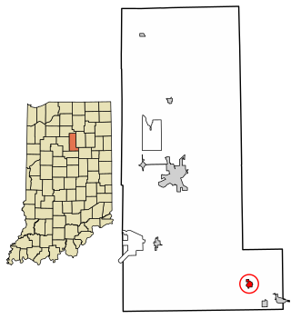
Converse is a town in Jackson Township, Miami County, and Richland Township, Grant County, in the U.S. state of Indiana. The population was 1,161 at the 2020 census.
North Salem is a town in Eel River Township, Hendricks County, Indiana, United States. The population was 518 at the 2010 Census.

Roanoke is a town in Jackson Township, Huntington County, Indiana, United States. The population was 1,762 at the 2020 census. Roanoke is governed by a town council. Town offices include the clerk treasurer, utilities department, police department, and volunteer fire department. The town has a public elementary school. WOWO and WRNP have transmitter towers in Roanoke, along U.S. Highway 24. For many years, television station WPTA was licensed to Roanoke, though that station's studios and transmitter have always been located in nearby Fort Wayne.

River Forest is a town in Anderson Township, Madison County, Indiana, United States. It is part of the Indianapolis–Carmel–Anderson metropolitan statistical area. The population was 26 at the 2020 census.

Woodlawn Heights is a town in Anderson Township, Madison County, Indiana, United States. It is part of the Indianapolis–Carmel–Anderson metropolitan statistical area. The population was 91 at the 2020 census.
Amboy is a town in Jackson Township, Miami County, in the U.S. state of Indiana. The population was 317 at the 2020 census, down from 384 in 2010.

Bunker Hill is a town in Pipe Creek Township, Miami County, in the U.S. state of Indiana. The population was 814 at the 2020 census, down from 888 in 2010.

Macy is a town in Allen Township, Miami County, in the U.S. state of Indiana. The population was 199 at the 2020 census.

Mexico is an unincorporated community and census-designated place (CDP) in Jefferson Township, Miami County, in the U.S. state of Indiana. The population was 915 at the 2020 census.

Bethany is a town in Clay Township, Morgan County, in the U.S. state of Indiana. The population was 95 at the 2020 census.

Paragon is a town in Ray Township, Morgan County, in the U.S. state of Indiana. The population was 556 at the 2020 census, down from 659 in 2010.

Lagro is a town in Lagro Township, Wabash County, in the U.S. state of Indiana. The population was 415 at the 2010 census.

Mount Auburn is a town in Jackson Township, Wayne County, in the U.S. state of Indiana. The population was 117 at the 2010 census. The town is sandwiched between Dublin and Cambridge City.

Ludlow Falls is a village in Miami County, Ohio, United States. The population was 175 at the 2020 census. It is part of the Dayton Metropolitan Statistical Area. Ludlow Falls is named after surveyor Israel Ludlow.

Wynnedale is a town in Washington Township, Marion County, Indiana, United States. The population was 215 at the 2020 census. It has existed as an "included town" since 1970, when it was incorporated into Indianapolis as part of Unigov. It is part of Indianapolis, but retains a functioning town government under IC 36-3-1-11.

