National Register of Historic Places listings in Sullivan County, Indiana

Last updated
Location of Sullivan County in Indiana Map of Indiana highlighting Sullivan County.svg
Location of Sullivan County in Indiana

This is a list of the National Register of Historic Places listings in Sullivan County, Indiana.

Contents

This is intended to be a complete list of the properties on the National Register of Historic Places in Sullivan County, Indiana, United States. Latitude and longitude coordinates are provided for many National Register properties; these locations may be seen together in a map. [1]

There are 11 properties listed on the National Register in the county.

Properties and districts located in incorporated areas display the name of the municipality, while properties and districts in unincorporated areas display the name of their civil township. Properties and districts split between multiple jurisdictions display the names of all jurisdictions.

This National Park Service list is complete through NPS recent listings posted August 13, 2021. [2]
Map all coordinates using: OpenStreetMap  
Download coordinates as: KML

Current listings

[3] Name on the Register [4] ImageDate listed [5] Location City or townDescription
1 Center Ridge Cemetery August 8, 2018
(#100002499)
704 W. Johnson St.
39°05′32″N87°25′20″W / 39.0922°N 87.4223°W / 39.0922; -87.4223 (Center Ridge Cemetery)
Hamilton Township
11 Daugherty-Monroe Archaeological Site (12SU13)
Daugherty-Monroe Archaeological Site (12SU13) Field and woods at Daugherty-Monroe.jpg
Daugherty-Monroe Archaeological Site (12SU13)
June 12, 1985
(#85001246)
Northern half of Section 21 Town 8 North Range 11 West [6]
39°07′30″N87°38′22″W / 39.125000°N 87.639444°W / 39.125000; -87.639444 (Daugherty-Monroe Archaeological Site (12SU13))
Turman Township
3 Merom Site and Fort Azatlan
Merom Site and Fort Azatlan Pathway at Fort Azatlan.jpg
Merom Site and Fort Azatlan
May 12, 1975
(#75000052)
North of Merom
39°03′45″N87°34′12″W / 39.062500°N 87.570000°W / 39.062500; -87.570000 (Merom Site and Fort Azatlan)
Gill Township and Merom
4 Merom-Gill Township Carnegie Library March 11, 2019
(#100003512)
8554 Market St.
39°03′23″N87°33′54″W / 39.0565°N 87.5649°W / 39.0565; -87.5649 (Merom-Gill Township Carnegie Library)
Merom
5 Shakamak State Park Historic District
Shakamak State Park Historic District Shakamak Nature Center 181.jpg
Shakamak State Park Historic District
March 15, 2000
(#00000199)
6265 W. State Road 48, west of Jasonville
39°10′35″N87°14′04″W / 39.176250°N 87.234500°W / 39.176250; -87.234500 (Shakamak State Park Historic District)
Jackson Township Extends into Clay and Greene counties
6 Shelburn Interurban Depot-THI&E Interurban Depot
Shelburn Interurban Depot-THI&E Interurban Depot Shelburn Interurban Depot-THI&E Interurban Depot.jpg
Shelburn Interurban Depot-THI&E Interurban Depot
December 15, 2015
(#15000890)
3 N. Railroad St.
39°10′40″N87°23′39″W / 39.177778°N 87.394028°W / 39.177778; -87.394028 (Shelburn Interurban Depot-THI&E Interurban Depot)
Shelburn
7 Sherman Building
Sherman Building Sherman Building in Sullivan.jpg
Sherman Building
September 22, 1986
(#86002712)
2-4 S. Court St.
39°05′43″N87°24′31″W / 39.095278°N 87.408611°W / 39.095278; -87.408611 (Sherman Building)
Sullivan
8 Sullivan County Courthouse
Sullivan County Courthouse Sullivan County Courthouse in Indiana, southwestern angle.jpg
Sullivan County Courthouse
December 22, 2008
(#08001213)
100 Courthouse Square
39°05′42″N87°24′28″W / 39.094903°N 87.407750°W / 39.094903; -87.407750 (Sullivan County Courthouse)
Sullivan
9 Sullivan Courthouse Square Historic District
Sullivan Courthouse Square Historic District Sullivan County Courthouse in Indiana, southern side.jpg
Sullivan Courthouse Square Historic District
September 4, 2018
(#100002867)
Roughly bounded by Section, Wall, State, and Harris Sts.
39°05′40″N87°24′30″W / 39.094444°N 87.408333°W / 39.094444; -87.408333 (Sullivan Courthouse Square Historic District)
Sullivan
10 Sullivan County Poor Home
Sullivan County Poor Home Sullivan County Poor Home.jpg
Sullivan County Poor Home
March 15, 2000
(#00000207)
1447 County Road 75N, east of Sullivan
39°05′51″N87°22′57″W / 39.0975°N 87.3825°W / 39.0975; -87.3825 (Sullivan County Poor Home)
Hamilton Township
2 Union Christian College
Union Christian College Union Christian College building in Merom.jpg
Union Christian College
June 25, 1982
(#82000076)
3rd and Philip Sts.
39°03′03″N87°33′53″W / 39.050833°N 87.564722°W / 39.050833; -87.564722 (Union Christian College)
Merom

See also

Related Research Articles

National Register of Historic Places listings in Allen County, Indiana

This is a list of the National Register of Historic Places listings in Allen County, Indiana.

National Register of Historic Places listings in Lake County, Indiana

This is a list of the National Register of Historic Places listings in Lake County, Indiana.

National Register of Historic Places listings in Vigo County, Indiana

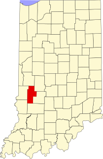
This is intended to be a complete list of the properties and districts on the National Register of Historic Places in Vigo County, Indiana, United States. Latitude and longitude coordinates are provided for many National Register properties and districts; these locations may be seen together in a map.

National Register of Historic Places listings in Porter County, Indiana

This is a list of the National Register of Historic Places listings in Porter County, Indiana.

National Register of Historic Places listings in Hamilton County, Indiana

This is a list of the National Register of Historic Places listings in Hamilton County, Indiana.

National Register of Historic Places listings in Bartholomew County, Indiana

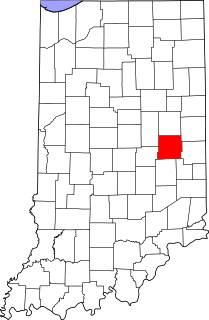
This is a list of the National Register of Historic Places listings in Bartholomew County, Indiana.

National Register of Historic Places listings in Clay County, Indiana

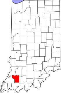
This is a list of the National Register of Historic Places listings in Clay County, Indiana.

National Register of Historic Places listings in Daviess County, Indiana

This is a list of the National Register of Historic Places listings in Daviess County, Indiana.

National Register of Historic Places listings in Gibson County, Indiana

This is a list of the National Register of Historic Places listings in Gibson County, Indiana.

National Register of Historic Places listings in Greene County, Indiana

This is a list of the National Register of Historic Places listings in Greene County, Indiana.

National Register of Historic Places listings in Henry County, Indiana

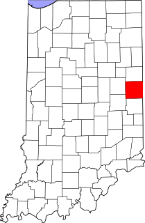
This is a list of the National Register of Historic Places listings in Henry County, Indiana.

National Register of Historic Places listings in Knox County, Indiana

This is a list of the National Register of Historic Places listings in Knox County, Indiana.

National Register of Historic Places listings in Lawrence County, Indiana

This is a list of the National Register of Historic Places listings in Lawrence County, Indiana.

National Register of Historic Places listings in Newton County, Indiana

This is a list of the National Register of Historic Places listings in Newton County, Indiana.

National Register of Historic Places listings in Perry County, Indiana

This is a list of the National Register of Historic Places listings in Perry County, Indiana.

National Register of Historic Places listings in Pike County, Indiana

This is a list of the National Register of Historic Places listings in Pike County, Indiana.

National Register of Historic Places listings in Posey County, Indiana

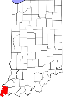
This is a list of the National Register of Historic Places listings in Posey County, Indiana.

National Register of Historic Places listings in Randolph County, Indiana

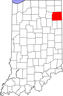
This is a list of the National Register of Historic Places listings in Randolph County, Indiana.

National Register of Historic Places listings in Vermillion County, Indiana

This is a list of the National Register of Historic Places listings in Vermillion County, Indiana.

National Register of Historic Places listings in Warren County, Indiana

This is a list of the National Register of Historic Places listings in Warren County, Indiana.

References

  1. The latitude and longitude information provided in this table was derived originally from the National Register Information System, which has been found to be fairly accurate for about 99% of listings. Some locations in this table may have been corrected to current GPS standards.
  2. National Park Service, United States Department of the Interior, "National Register of Historic Places: Weekly List Actions", retrieved August 13, 2021.
  3. Numbers represent an alphabetical ordering by significant words. Various colorings, defined here, differentiate National Historic Landmarks and historic districts from other NRHP buildings, structures, sites or objects.
  4. "National Register Information System". National Register of Historic Places . National Park Service. March 13, 2009.
  5. The eight-digit number below each date is the number assigned to each location in the National Register Information System database, which can be viewed by clicking the number.
  6. Location derived from Clouse, R.O., et al. "Interim Report of the Daughtery-Monroe Site: An Allison-LaMotte Village." Proceedings of the Indiana Academy of Science 80 (1971): 74-83. The NRIS lists the site as "Address Restricted".