National Register of Historic Places listings in Clay County, Indiana

Last updated

Location of Clay County in Indiana Map of Indiana highlighting Clay County.svg
Location of Clay County in Indiana

This is a list of the National Register of Historic Places listings in Clay County, Indiana.

Contents

This is intended to be a complete list of the properties and districts on the National Register of Historic Places in Clay County, Indiana, United States. Latitude and longitude coordinates are provided for many National Register properties and districts; these locations may be seen together in a map. [1]

There are 13 properties and districts listed on the National Register in the county. Another two properties were once listed but have been removed.

Properties and districts located in incorporated areas display the name of the municipality, while properties and districts in unincorporated areas display the name of their civil township. Properties and districts split between multiple jurisdictions display the names of all jurisdictions.


    This National Park Service list is complete through NPS recent listings posted March 4, 2022. [2]

Map all coordinates using: OpenStreetMap  
Download coordinates as: KML

Current listings

[3] Name on the Register [4] ImageDate listed [5] Location City or townDescription
1 Aqueduct Bridge
Aqueduct Bridge Aqueduct Bridge.jpg
Aqueduct Bridge
March 15, 2000
(#00000209)
Towpath Rd. over Birch Creek, northwest of Clay City
39°19′36″N87°10′46″W / 39.326667°N 87.179444°W / 39.326667; -87.179444 (Aqueduct Bridge)
Perry and Sugar Ridge Townships
2 Brazil Downtown Historic District
Brazil Downtown Historic District West National in downtown Brazil.jpg
Brazil Downtown Historic District
June 25, 1997
(#97000601)
E. and W. National Ave. between Depot and Forest Aves.
39°31′23″N87°07′39″W / 39.523056°N 87.1275°W / 39.523056; -87.1275 (Brazil Downtown Historic District)
Brazil
3 Clay County Courthouse
Clay County Courthouse Clay County Courthouse, Brazil.jpg
Clay County Courthouse
September 9, 1999
(#99001109)
Bounded by U.S. Route 40, Harrison, Jackson, and Alabama Sts.
39°31′28″N87°07′11″W / 39.524444°N 87.119722°W / 39.524444; -87.119722 (Clay County Courthouse)
Brazil
4 Clay County Hospital
Clay County Hospital Clay County Hospital at Brazil.jpg
Clay County Hospital
October 1, 1999
(#99001154)
1200 E. National Ave.
39°31′43″N87°06′41″W / 39.528611°N 87.111389°W / 39.528611; -87.111389 (Clay County Hospital)
Brazil
5 Eaglefield Place
Eaglefield Place Eaglefield Place farmhouse.jpg
Eaglefield Place
August 28, 1998
(#98001104)
4870 E. U.S. Route 40, east of Brazil
39°32′50″N87°00′56″W / 39.547222°N 87.015556°W / 39.547222; -87.015556 (Eaglefield Place)
Van Buren Township
6 Feeder Dam Bridge
Feeder Dam Bridge Feeder Dam Bridge.jpg
Feeder Dam Bridge
March 15, 2000
(#00000215)
Towpath Rd. over the Eel River, north of Clay City
39°20′09″N87°06′49″W / 39.335833°N 87.113611°W / 39.335833; -87.113611 (Feeder Dam Bridge)
Harrison and Sugar Ridge Townships
7 Indiana State Highway Bridge 42-11-3101
Indiana State Highway Bridge 42-11-3101 Indiana State Road 42 Bridge over Eel River, southern side and eastern portal.jpg
Indiana State Highway Bridge 42-11-3101
March 15, 2000
(#00000210)
State Road 42 over the Eel River, west of Poland
39°26′40″N86°59′37″W / 39.444444°N 86.993611°W / 39.444444; -86.993611 (Indiana State Highway Bridge 42-11-3101)
Cass Township
8 Jeffers Bridge
Jeffers Bridge Jeffers Bridge western portal closeup.jpg
Jeffers Bridge
March 15, 2000
(#00000213)
County Road 200S over Birch Creek, north of Clay City
39°21′31″N87°08′32″W / 39.358611°N 87.142222°W / 39.358611; -87.142222 (Jeffers Bridge)
Perry and Sugar Ridge Townships
9 Meridian-Forest Historic District
Meridian-Forest Historic District Library in Brazil, Indiana.jpg
Meridian-Forest Historic District
June 26, 1997
(#97000600)
Roughly bounded by N. Meridian, E. Chestnut, N. Forest, E. and W. Church, and State Sts.
39°31′41″N87°07′41″W / 39.528056°N 87.128056°W / 39.528056; -87.128056 (Meridian-Forest Historic District)
Brazil
10 Poland Presbyterian Church and Cemetery
Poland Presbyterian Church and Cemetery Poland Presbyterian Church and Cemetery.jpg
Poland Presbyterian Church and Cemetery
December 18, 1990
(#90001932)
State Road 42 near County Road 56S at Poland
39°26′41″N86°57′14″W / 39.444722°N 86.953889°W / 39.444722; -86.953889 (Poland Presbyterian Church and Cemetery)
Cass Township
11 Shakamak State Park Historic District
Shakamak State Park Historic District Shakamak State Park gatehouse.jpg
Shakamak State Park Historic District
March 15, 2000
(#00000199)
6265 W. State Road 48, northwest of Jasonville
39°10′35″N87°14′04″W / 39.176250°N 87.234500°W / 39.176250; -87.234500 (Shakamak State Park Historic District)
Lewis Township Extends into Greene and Sullivan counties
12 Tide Water Pumping Station
Tide Water Pumping Station Tide Water Pumping Station main building.jpg
Tide Water Pumping Station
September 3, 1999
(#99001076)
Southwestern corner of the junction of 900S and 300E, north of Coal City
39°15′16″N87°03′21″W / 39.254444°N 87.055833°W / 39.254444; -87.055833 (Tide Water Pumping Station)
Harrison Township
13 US Post Office-Brazil
US Post Office-Brazil Post office in Brazil, Indiana.jpg
US Post Office-Brazil
September 8, 1994
(#94001132)
100 E. National Ave.
39°31′26″N87°07′33″W / 39.523889°N 87.125833°W / 39.523889; -87.125833 (US Post Office-Brazil)
Brazil

Former listing

[3] Name on the RegisterImageDate listedDate removedLocationCity or townDescription
1 Coal Company Store May 22, 1986
(#86001121)
February 7, 1992S. Harmony Rd.
Harmony
2 Indiana State Highway Bridge 46-11-1316
Indiana State Highway Bridge 46-11-1316 Indiana State Road 46 Bridge over Eel River, southwestern angle with sunlight.jpg
Indiana State Highway Bridge 46-11-1316
March 15, 2000
(#00000211)
December 9, 2020 State Road 46 over the Eel River at Bowling Green
39°23′03″N87°01′14″W / 39.384167°N 87.020556°W / 39.384167; -87.020556 (Indiana State Highway Bridge 46-11-1316)
Washington Township

See also

Related Research Articles

National Register of Historic Places listings in Vigo County, Indiana

This is intended to be a complete list of the properties and districts on the National Register of Historic Places in Vigo County, Indiana, United States. Latitude and longitude coordinates are provided for many National Register properties and districts; these locations may be seen together in a map.

National Register of Historic Places listings in Parke County, Indiana

This is a list of the National Register of Historic Places listings in Parke County, Indiana.

National Register of Historic Places listings in Adams County, Indiana

This is a list of the National Register of Historic Places listings in Adams County, Indiana.

National Register of Historic Places listings in Benton County, Indiana

This is a list of the National Register of Historic Places listings in Benton County, Indiana.

National Register of Historic Places listings in Blackford County, Indiana

This is a list of the National Register of Historic Places listings in Blackford County, Indiana.

National Register of Historic Places listings in Cass County, Indiana

This is a list of the National Register of Historic Places listings in Cass County, Indiana.

National Register of Historic Places listings in Montgomery County, Indiana

This is a list of the National Register of Historic Places listings in Montgomery County, Indiana.

National Register of Historic Places listings in Whitley County, Indiana

This is a list of the National Register of Historic Places listings in Whitley County, Indiana.

National Register of Historic Places listings in Franklin County, Indiana

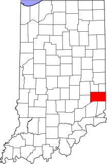
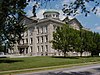
This is a list of the National Register of Historic Places listings in Franklin County, Indiana.

National Register of Historic Places listings in Greene County, Indiana

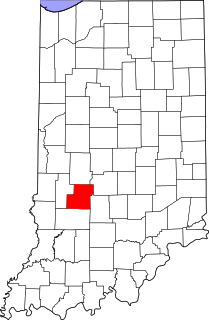
This is a list of the National Register of Historic Places listings in Greene County, Indiana.

National Register of Historic Places listings in Howard County, Indiana

This is a list of the National Register of Historic Places listings in Howard County, Indiana.

National Register of Historic Places listings in Jefferson County, Indiana

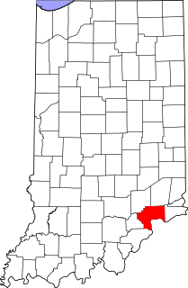
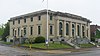
This is a list of the National Register of Historic Places listings in Jefferson County, Indiana.

National Register of Historic Places listings in Johnson County, Indiana

This is a list of the National Register of Historic Places listings in Johnson County, Indiana.

National Register of Historic Places listings in Orange County, Indiana

This is a list of the National Register of Historic Places listings in Orange County, Indiana.

National Register of Historic Places listings in Owen County, Indiana

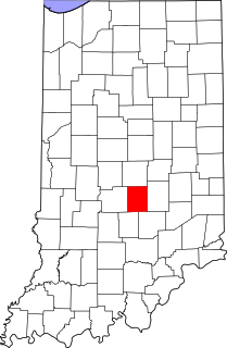
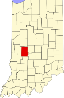
This is a list of the National Register of Historic Places listings in Owen County, Indiana.

National Register of Historic Places listings in Putnam County, Indiana

This is a list of the National Register of Historic Places listings in Putnam County, Indiana.

National Register of Historic Places listings in Ripley County, Indiana

This is a list of the National Register of Historic Places listings in Ripley County, Indiana.

National Register of Historic Places listings in Sullivan County, Indiana

This is a list of the National Register of Historic Places listings in Sullivan County, Indiana.

National Register of Historic Places listings in Warren County, Indiana

This is a list of the National Register of Historic Places listings in Warren County, Indiana.

National Register of Historic Places listings in Grant County, Indiana

This is a list of the National Register of Historic Places listings in Grant County, Indiana.

References

  1. The latitude and longitude information provided in this table was derived originally from the National Register Information System, which has been found to be fairly accurate for about 99% of listings. Some locations in this table may have been corrected to current GPS standards.
  2. National Park Service, United States Department of the Interior, "National Register of Historic Places: Weekly List Actions", retrieved March 4, 2022.
  3. 1 2 Numbers represent an alphabetical ordering by significant words. Various colorings, defined here, differentiate National Historic Landmarks and historic districts from other NRHP buildings, structures, sites or objects.
  4. "National Register Information System". National Register of Historic Places . National Park Service. March 13, 2009.
  5. The eight-digit number below each date is the number assigned to each location in the National Register Information System database, which can be viewed by clicking the number.