
Clay County is a county located in the U.S. state of Indiana. As of 2020, the population was 26,466. The county seat is Brazil.

Brazil Township is one of eleven townships in Clay County, Indiana. As of the 2010 census, its population was 8,604 and it contained 3,813 housing units.

Cass Township is one of eleven townships in Clay County, Indiana. As of the 2020 census, its population was 346 and it contained 148 housing units.

Dick Johnson Township is one of eleven townships in Clay County, Indiana. As of the 2020 census, its population was 1,355 and it contained 576 housing units.

Harrison Township is one of eleven townships in Clay County, Indiana. As of the 2020 census, its population was 2,151 and it contained 1,025 housing units.

Jackson Township is one of eleven townships in Clay County, Indiana. As of the 2020 census, its population was 2,839 and it contained 1,187 housing units.

Lewis Township is one of eleven townships in Clay County, Indiana. As of the 2020 census, its population was 1,373 and it contained 613 housing units.

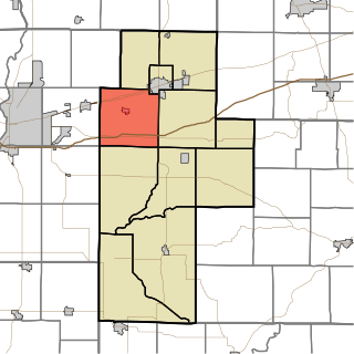
Perry Township is one of eleven townships in Clay County, Indiana. As of the 2020 census, its population was 915 and it contained 417 housing units.
Posey Township is one of eleven townships in Clay County, Indiana. As of the 2020 census, its population was 4,016 and it contained 1,682 housing units.

Sugar Ridge Township is one of eleven townships in Clay County, Indiana. As of the 2020 census, its population was 914 and it contained 438 housing units.

Van Buren Township is one of eleven townships in Clay County, Indiana. As of the 2020 census, its population was 3,203 and it contained 1,415 housing units.

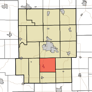
Washington Township is one of eleven townships in Clay County, Indiana. As of the 2020 census, its population was 750 and it contained 346 housing units.

Clay Township is one of fourteen townships in Carroll County, Indiana. As of the 2020 census, its population was 1,218 and it contained 475 housing units. Clay Township is part of the Rossville, Indiana school district.

Clay Township is one of nine townships in Spencer County, Indiana. As of the 2020 census, its population was 2,862 and it contained 1,216 housing units.

Clay Township is one of fourteen townships in Cass County, Indiana, United States, and one of the seventeen townships sharing the name in the state. As of the 2020 census, its population was 2,842 and it contained 1,177 housing units.

Clay Township is one of fourteen townships in Dearborn County, Indiana. As of the 2010 census, its population was 2,966 and it contained 1,271 housing units.

Clay Township is one of nine townships in Decatur County, Indiana. As of the 2020 census, its population was 1,284 and it contained 523 housing units.
Clay Township is one of 17 townships in Kosciusko County, Indiana. As of the 2020 census, its population was 1,657 and it contained 753 housing units.

Bowling Green is an unincorporated town in Washington Township, Clay County, Indiana. It is part of the Terre Haute Metropolitan Statistical Area.
Perth is an unincorporated community in Dick Johnson Township, Clay County, Indiana. It is part of the Terre Haute Metropolitan Statistical Area.

