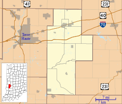
Clay County is a county located in the U.S. state of Indiana. As of 2010, the population was 26,890. The county seat is Brazil.

Jackson Township is one of thirteen townships in Parke County, Indiana, United States. As of the 2010 census, its population was 737 and it contained 475 housing units.

Jefferson Township is one of thirteen townships in Owen County, Indiana, United States. As of the 2010 census, its population was 1,129 and it contained 525 housing units.

Marion Township is one of thirteen townships in Owen County, Indiana, United States. As of the 2010 census, its population was 916 and it contained 464 housing units.

Art is an unincorporated community in Perry Township, Clay County, Indiana. It is part of the Terre Haute Metropolitan Statistical Area.

Ashboro is an unincorporated community in Sugar Ridge Township, Clay County, Indiana. It is part of the Terre Haute Metropolitan Statistical Area.

Asherville is an unincorporated community in Jackson Township, Clay County, Indiana. It is part of the Terre Haute Metropolitan Statistical Area.

Benwood is an unincorporated community in Van Buren Township, Clay County, Indiana, United States. It is part of the Terre Haute Metropolitan Statistical Area.

Billtown is an unincorporated community in Posey Township, Clay County, Indiana. It is part of the Terre Haute Metropolitan Statistical Area.

Bowling Green is an unincorporated community in Washington Township, Clay County, Indiana. It is part of the Terre Haute Metropolitan Statistical Area.

Cardonia is an unincorporated community in Van Buren Township, Clay County, Indiana. It is part of the Terre Haute Metropolitan Statistical Area.

Cloverland is an unincorporated community in Posey Township, Clay County, Indiana. It is part of the Terre Haute Metropolitan Statistical Area.

Coalmont is an unincorporated community and census-designated place in Lewis Township, Clay County, Indiana, United States. It is part of the Terre Haute Metropolitan Statistical Area. As of the 2010 census it had a population of 402.

Hoosierville is an unincorporated community in Jackson Township, Clay County, Indiana. It is part of the Terre Haute Metropolitan Statistical Area.

Perth is an unincorporated community in Dick Johnson Township, Clay County, Indiana. It is part of the Terre Haute Metropolitan Statistical Area.

Saline City is an unincorporated community in Sugar Ridge Township, Clay County, Indiana. It is part of the Terre Haute Metropolitan Statistical Area.

Cherryvale is an unincorporated community in Vigo and Clay counties, in the U.S. state of Indiana.

Buchanan Corner is an unincorporated community in Lewis Township, Clay County, Indiana, United States. It is part of the Terre Haute Metropolitan Statistical Area.

Middlebury is an unincorporated community in Harrison Township, Clay County, Indiana. It is part of the Terre Haute Metropolitan Statistical Area.
Calcutta is an unincorporated community in Clay County, Indiana, in the United States.


