Shady Lane, Indiana

Last updated
Shady Lane
Unincorporated community
Location map of Clay County, Indiana.svg
Red pog.svg
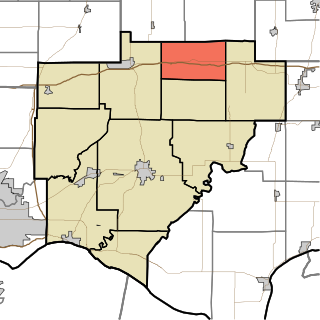
Shady Lane
Location in Clay County
Coordinates: 39°32′44″N87°08′01″W / 39.54556°N 87.13361°W / 39.54556; -87.13361 Coordinates: 39°32′44″N87°08′01″W / 39.54556°N 87.13361°W / 39.54556; -87.13361
Country United States
State Indiana
County Clay
Township Brazil
Elevation 653 ft (199 m)
GNIS feature ID 443250 [1]

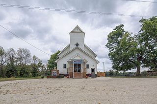
Shady Lane is an unincorporated community in Brazil Township, Clay County, Indiana. It is part of the Terre Haute Metropolitan Statistical Area.

Unincorporated area Region of land not governed by own local government

In law, an unincorporated area is a region of land that is not governed by a local municipal corporation; similarly an unincorporated community is a settlement that is not governed by its own local municipal corporation, but rather is administered as part of larger administrative divisions, such as a township, parish, borough, county, city, canton, state, province or country. Occasionally, municipalities dissolve or disincorporate, which may happen if they become fiscally insolvent, and services become the responsibility of a higher administration. Widespread unincorporated communities and areas are a distinguishing feature of the United States and Canada. In most other countries of the world, there are either no unincorporated areas at all, or these are very rare; typically remote, outlying, sparsely populated or uninhabited areas.

Brazil Township, Clay County, Indiana Township in Indiana, United States

Brazil Township is one of eleven townships in Clay County, Indiana. As of the 2010 census, its population was 8,471 and it contained 3,806 housing units.

Clay County, Indiana county located in the U.S. state of Indiana

Clay County is a county located in the U.S. state of Indiana. As of 2010, the population was 26,890. The county seat is Brazil.

Shady Lane was named from its tree-lined streets. [2]

Geography

Shady Lane is located at 39°32′44″N87°08′01″W / 39.54556°N 87.13361°W / 39.54556; -87.13361 .

Related Research Articles

West Charleston, Ohio human settlement in United States of America

West Charleston is an unincorporated community in western Bethel Township, Miami County, Ohio, United States.

Clinton Township, Vermillion County, Indiana Township in Indiana, United States

Clinton Township is one of five townships in Vermillion County, Indiana, United States. As of the 2010 census, its population was 9,119 and it contained 4,281 housing units.

Greene Township, Parke County, Indiana Township in Indiana, United States

Greene Township is one of thirteen townships in Parke County, Indiana, United States. As of the 2010 census, its population was 423 and it contained 191 housing units.

Jackson Township, Parke County, Indiana Township in Indiana, United States

Jackson Township is one of thirteen townships in Parke County, Indiana, United States. As of the 2010 census, its population was 737 and it contained 475 housing units.

Liberty Township, Parke County, Indiana Township in Indiana, United States

Liberty Township is one of thirteen townships in Parke County, Indiana, United States. As of the 2010 census, its population was 739 and it contained 324 housing units.

Penn Township, Parke County, Indiana Township in Indiana, United States

Penn Township is one of thirteen townships in Parke County, Indiana, United States. As of the 2010 census, its population was 810 and it contained 368 housing units.

Wabash Township, Parke County, Indiana Township in Indiana, United States

Wabash Township is one of thirteen townships in Parke County, Indiana, United States. As of the 2010 census, its population was 818 and it contained 353 housing units.

Washington Township, Parke County, Indiana Township in Indiana, United States

Washington Township is one of thirteen townships in Parke County, Indiana, United States. As of the 2010 census, its population was 1,302 and it contained 457 housing units.

Hart Township, Warrick County, Indiana Township in Indiana, United States

Hart Township is one of ten townships in Warrick County, Indiana, United States. As of the 2010 census, its population was 1,626 and it contained 691 housing units.

Lane Township, Warrick County, Indiana Township in Indiana, United States

Lane Township is one of ten townships in Warrick County, Indiana, United States. As of the 2010 census, its population was 281 and it contained 119 housing units.

Island City, Indiana Unincorporated community in Indiana, United States

Island City is an unincorporated community in Stockton Township, Greene County, Indiana.

Şarifan Place in Zangilan, Azerbaijan

Şarifan is a village in the Zangilan Rayon of Azerbaijan.

Benevola is an unincorporated community in Washington County, Maryland, United States.

University Parkway is a four-lane road that will link the Lloyd Expressway and the University of Southern Indiana with Interstate 64

Prairie City, Indiana Unincorporated community in Indiana, United States

Prairie City is an unincorporated community in Jackson Township, Clay County, Indiana. It is part of the Terre Haute Metropolitan Statistical Area.

Lone Tree is an unincorporated community in Greene County, Indiana, in the United States.

Sponsler is an unincorporated community in Greene County, Indiana, in the United States.

Monterey is an unincorporated community in Clermont County, in the U.S. state of Ohio.

Beesons, Indiana Unincorporated community in Indiana, United States

Beesons is an unincorporated community in Washington Township, Wayne County, in the U.S. state of Indiana.

Germantown is an unincorporated community in Franklin County, in the U.S. state of Pennsylvania.

References

  1. "Shady Lane, Indiana". Geographic Names Information System . United States Geological Survey . Retrieved 2010-08-20.
  2. Baker, Ronald L. (October 1995). From Needmore to Prosperity: Hoosier Place Names in Folklore and History. Indiana University Press. p. 298. ISBN   978-0-253-32866-3. ...name from the rows of sycamore trees...