Asherville, Indiana

Last updated

Asherville
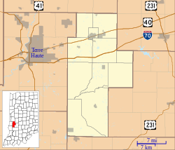
Location map of Clay County, Indiana.svg
Red pog.svg
Asherville
Location in Clay County
Coordinates: 39°28′29″N87°03′44″W / 39.47472°N 87.06222°W / 39.47472; -87.06222
Country United States
State Indiana
County Clay
Township Jackson
Elevation
659 ft (201 m)
ZIP code
47834
FIPS code 18-02368 [1]
GNIS feature ID447632 [2]

Asherville is an unincorporated community in Jackson Township, Clay County, Indiana. It is part of the Terre Haute Metropolitan Statistical Area.
Contents

History

John Asher laid out Asherville in 1873. [3] At the same time, a post office was built and remained in operation until its discontinuation in 1912. [4]

Geography

Asherville is located at 39°28′29″N87°03′44″W / 39.47472°N 87.06222°W / 39.47472; -87.06222 .

Related Research Articles

<span class="mw-page-title-main">Clay County, Indiana</span> County in Indiana, United States

Clay County is a county located in the U.S. state of Indiana. As of 2020, the population was 26,466. The county seat is Brazil.

<span class="mw-page-title-main">Jackson Township, Parke County, Indiana</span> Township in Indiana, United States

Jackson Township is one of thirteen townships in Parke County, Indiana, United States. As of the 2010 census, its population was 737 and it contained 475 housing units.

<span class="mw-page-title-main">Jefferson Township, Owen County, Indiana</span> Township in Indiana, United States

Jefferson Township is one of thirteen townships in Owen County, Indiana, United States. As of the 2010 census, its population was 1,129 and it contained 525 housing units.

<span class="mw-page-title-main">Marion Township, Owen County, Indiana</span> Township in Indiana, United States

Marion Township is one of thirteen townships in Owen County, Indiana, United States. As of the 2010 census, its population was 916 and it contained 464 housing units.

<span class="mw-page-title-main">Stony Lonesome, Indiana</span> Unincorporated community in Indiana, United States

Stony Lonesome is an unincorporated community in Harrison Township, Bartholomew County, in the U.S. state of Indiana.

<span class="mw-page-title-main">Art, Indiana</span> Unincorporated community in Indiana, United States

Art is an unincorporated community in Perry Township, Clay County, Indiana. It is part of the Terre Haute Metropolitan Statistical Area.

Ashboro is an unincorporated community in Sugar Ridge Township, Clay County, Indiana. It is part of the Terre Haute Metropolitan Statistical Area.

Bee Ridge is an unincorporated community in Dick Johnson Township, Clay County, Indiana. It is part of the Terre Haute Metropolitan Statistical Area.

Benwood is an unincorporated community in Van Buren Township, Clay County, Indiana, United States. It is part of the Terre Haute Metropolitan Statistical Area. Benwood is located at 39°33′40″N87°06′51″W.

Billtown is an unincorporated community in Posey Township, Clay County, Indiana. It is part of the Terre Haute Metropolitan Statistical Area.

<span class="mw-page-title-main">Bowling Green, Indiana</span> Unincorporated community in Indiana, United States

Bowling Green is an unincorporated community in Washington Township, Clay County, Indiana. It is part of the Terre Haute Metropolitan Statistical Area.

Cardonia is an unincorporated community in Van Buren Township, Clay County, Indiana. It is part of the Terre Haute Metropolitan Statistical Area.

<span class="mw-page-title-main">Cloverland, Indiana</span> Unincorporated community in Indiana, United States

Cloverland is an unincorporated community in Posey Township, Clay County, Indiana. It is part of the Terre Haute Metropolitan Statistical Area.

<span class="mw-page-title-main">Coalmont, Indiana</span> Census-designated place in Indiana, United States

Coalmont is an unincorporated community and census-designated place in Lewis Township, Clay County, Indiana, United States. It is part of the Terre Haute Metropolitan Statistical Area. As of the 2010 census it had a population of 402.

Hoosierville is an unincorporated community in Jackson Township, Clay County, Indiana. It is part of the Terre Haute Metropolitan Statistical Area.

Howesville is an unincorporated community in Lewis Township, Clay County, Indiana. It is part of the Terre Haute Metropolitan Statistical Area.

Perth is an unincorporated community in Dick Johnson Township, Clay County, Indiana. It is part of the Terre Haute Metropolitan Statistical Area.

<span class="mw-page-title-main">Saline City, Indiana</span> Unincorporated community in Indiana, United States

Saline City is an unincorporated community in Sugar Ridge Township, Clay County, Indiana. It is part of the Terre Haute Metropolitan Statistical Area.

Stearleyville is an unincorporated community in Jackson Township, Clay County, Indiana.

Pontiac is an unincorporated community in Van Buren Township, Clay County, Indiana. It is part of the Terre Haute Metropolitan Statistical Area.

References

  1. "U.S. Census website". United States Census Bureau . Retrieved January 31, 2008.
  2. "Asherville, Indiana". Geographic Names Information System . United States Geological Survey, United States Department of the Interior . Retrieved October 10, 2009.
  3. Blanchard, Charles (1884). Counties of Clay and Owen, Indiana: Historical and Biographical. F.A. Battey & Company. pp.  298.
  4. "Clay County". Jim Forte Postal History. Retrieved August 30, 2014.