Bowling Green, Indiana

Last updated

Bowling Green
Bowling Green, Indiana.jpg
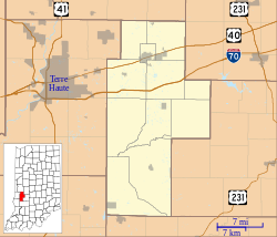
Location map of Clay County, Indiana.svg
Red pog.svg
Bowling Green
Location in Clay County
Coordinates: 39°22′59″N87°00′42″W / 39.38306°N 87.01167°W / 39.38306; -87.01167
Country United States
State Indiana
County Clay
Township Washington
Elevation
653 ft (199 m)
Time zone UTC-5:00 (EST)
  Summer (DST) UTC-5:00 (EDT)
ZIP code
47833
Area code 812
FIPS code 18-06832 [1]
GNIS feature ID431404 [2]

Bowling Green is an unincorporated community in Washington Township, Clay County, Indiana. It is part of the Terre Haute Metropolitan Statistical Area.
Contents

History

The town was probably named after Bowling Green, Virginia. [3] The first post office was established at Bowling Green in 1825. [4] With the establishment of Clay County in the same year, Bowling Green became the site of the county's first courthouse, which was completed in 1828. [5] Bowling Green was incorporated as a town in 1869, [6] but subsequently lost its status as county seat to the town of Brazil in 1876. [5]

Geography

Bowling Green is located at 39°22′59″N87°00′42″W / 39.38306°N 87.01167°W / 39.38306; -87.01167 .

Climate

The climate of Bowling Green is characterized by relatively high temperatures and evenly distributed precipitation throughout the year. The Köppen Climate Classification subtype for this climate is "Cfa". (Humid Subtropical Climate). [7]

Demographics

Historical population
CensusPop.Note
1850 318
1860 46646.5%
1870 60630.0%
1880 572−5.6%
1890 467−18.4%
1900 432−7.5%
1910 336−22.2%
1920 273−18.7%
1930 257−5.9%
1940 219−14.8%
1950 2357.3%
1960 229−2.6%
U.S. Decennial Census [8]

Bowling Green appeared on U.S. Census returns between 1850 and 1960. Its population peaked in 1870, when it had a reported 606 inhabitants.

Notable people

Related Research Articles

<span class="mw-page-title-main">Clay County, Florida</span> County in Florida, United States

Clay County is located in the northeastern part of the U.S. state of Florida along the west bank of the St. Johns River. As of 2020, the population was 218,245 and in 2022, that number increased to 226,589, making it the third largest county in the Jacksonville metropolitan area. While most of the county is unincorporated, there are 4 municipalities with Green Cove Springs being the county seat and the unincorporated Lakeside CDP being the largest place. It is named in honor of Henry Clay, a famous American statesman, member of the United States Senate from Kentucky, and United States Secretary of State in the 19th century.

<span class="mw-page-title-main">Clay County, Indiana</span> County in Indiana, United States

Clay County is a county located in the U.S. state of Indiana. As of 2020, the population was 26,466. The county seat is Brazil.

<span class="mw-page-title-main">Caroline County, Virginia</span> County in Virginia, United States

Caroline County is a United States county located in the eastern part of the Commonwealth of Virginia. The northern boundary of the county borders on the Rappahannock River, notably at the historic town of Port Royal. The Caroline county seat is Bowling Green.

<span class="mw-page-title-main">Brazil, Indiana</span> City in Indiana, United States

Brazil is a city in Clay County, Indiana, United States. The population was 7,912 at the 2010 census. The city is the county seat of Clay County. It is part of the Terre Haute Metropolitan Statistical Area. The current chief executive of Brazil is Mayor Brian Wyndham (Democrat).

<span class="mw-page-title-main">Carbon, Indiana</span> Town in Indiana, United States

Carbon is a town in Van Buren Township, Clay County, Indiana, United States. The population was 397 at the 2010 census. It is part of the Terre Haute Metropolitan Statistical Area.

<span class="mw-page-title-main">Clay City, Indiana</span> Town in Indiana, United States

Clay City is a town in Harrison Township, Clay County, Indiana, United States. The population was 861 at the 2010 census. It is part of the Terre Haute Metropolitan Statistical Area.

<span class="mw-page-title-main">Knightsville, Indiana</span> Town in Indiana, United States

Knightsville is a town in Van Buren Township, Clay County, Indiana, United States. The population was 872 at the 2010 census. It is part of the Terre Haute Metropolitan Statistical Area.

<span class="mw-page-title-main">Staunton, Indiana</span> Town in Indiana, United States

Staunton is a town in Posey Township, Clay County, Indiana, United States. The population was 534 at the 2010 census. It is part of the Terre Haute Metropolitan Statistical Area.

<span class="mw-page-title-main">Switz City, Indiana</span> Town in Indiana, United States

Switz City is a town in Fairplay and Grant townships, Greene County, Indiana, United States. The population was 293 at the 2010 census. It is part of the Bloomington, Indiana, Metropolitan Statistical Area.

<span class="mw-page-title-main">Speedway, Indiana</span> Town in the United States

Speedway is a town in Wayne Township, Marion County, Indiana, United States. The population was 13,952 at the 2020 census, up from 11,812 in 2010. Speedway, which is an enclave of Indianapolis, is the home of the Indianapolis Motor Speedway.

<span class="mw-page-title-main">Farmersburg, Indiana</span> Town in Indiana, United States

Farmersburg is a town in Curry Township, Sullivan County, Indiana, United States. The population was 1,118 at the 2010 census. It is part of the Terre Haute Metropolitan Statistical Area. The town is adjacent to the Vigo County line and is overshadowed by several large TV and radio transmitter towers.

<span class="mw-page-title-main">Bowling Green, Virginia</span> Town in Virginia, United States

Bowling Green is an incorporated town in Caroline County, Virginia, United States. The population was 1,111 at the 2010 census.

<span class="mw-page-title-main">Berryville, Virginia</span> Town in Virginia

Berryville is an incorporated town in and the county seat of Clarke County, Virginia, United States. The population was 4,574 at the 2020 census, up from 4,185 at the 2010 census.

<span class="mw-page-title-main">Warrenton, Virginia</span> Town in Virginia, United States

Warrenton is a town in Fauquier County, Virginia, of which it is the seat of government. The population was 10,057 as of the 2020 census, an increase from 9,611 at the 2010 census and 6,670 at the 2000 census. The estimated population in July 2021 was 10,109. It is at the junction of U.S. Route 15, U.S. Route 17, U.S. Route 29, and U.S. Route 211. The town is in the Piedmont region of Virginia just east of the Blue Ridge Mountains. The well-known Airlie Conference Center is 3 miles (5 km) north of Warrenton, and the historic Vint Hill Farms military facility is 9 miles (14 km) east. Fauquier Hospital is located in the town. Surrounded by Virginia wine and horse country, Warrenton is a popular destination outside Washington, D.C.

<span class="mw-page-title-main">Tazewell, Virginia</span> Town in Virginia, United States

Tazewell is a town in Tazewell County, Virginia, United States. The population was 4,627 at the 2010 census. It is part of the Bluefield, WV-VA micropolitan area, which has a population of 107,578. It is the county seat of Tazewell County.

<span class="mw-page-title-main">Clay, West Virginia</span> Town in West Virginia, United States

Clay is a town in and the county seat of Clay County, West Virginia, United States. The population was 399 at the 2020 census. It is the only incorporated town in Clay County.

<span class="mw-page-title-main">Bruceton Mills, West Virginia</span> Town in West Virginia, United States

Bruceton Mills is a town in northern Preston County, West Virginia, United States, along Big Sandy Creek. The population was 64 at the 2020 census, making it the second-least populous town in West Virginia, after Thurmond. It is part of the Morgantown metropolitan area.

<span class="mw-page-title-main">Waldron, Indiana</span> Census-designated place in Indiana, United States

Waldron is an unincorporated community and census-designated place in Liberty Township, Shelby County, in the U.S. state of Indiana.

<span class="mw-page-title-main">Cloverland, Indiana</span> Unincorporated community in Indiana, United States

Cloverland is an unincorporated community in Posey Township, Clay County, Indiana. It is part of the Terre Haute Metropolitan Statistical Area.

<span class="mw-page-title-main">Coalmont, Indiana</span> Census-designated place in Indiana, United States

Coalmont is an unincorporated community and census-designated place in Lewis Township, Clay County, Indiana, United States. It is part of the Terre Haute Metropolitan Statistical Area. As of the 2010 census it had a population of 402.

References

  1. "U.S. Census website". United States Census Bureau . Retrieved January 31, 2008.
  2. "Bowling Green, Indiana". Geographic Names Information System . United States Geological Survey, United States Department of the Interior . Retrieved October 10, 2009.
  3. Baker, Ronald L. (October 1995). From Needmore to Prosperity: Hoosier Place Names in Folklore and History . Indiana University Press. p.  73. ISBN   978-0-253-32866-3. ...but more likely the village was named for Bowling Green, Virginia...
  4. "Clay County". Jim Forte Postal History. Archived from the original on September 3, 2014. Retrieved August 30, 2014.
  5. 1 2 "History | Clay County Indiana". www.claycountyin.gov. Retrieved May 19, 2021.
  6. Blanchard, Charles (1884). Counties of Clay and Owen, Indiana: Historical and Biographical. F.A. Battey & Company. pp.  175.
  7. Climate Summary for Bowling Green, Indiana
  8. "Census of Population and Housing". Census.gov. Retrieved May 18, 2021.
  9. "Beamer, George N." Federal Judicial Center.