Eel River, Clay County, Indiana

Last updated

Eel River
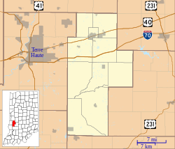
Location map of Clay County, Indiana.svg
Red pog.svg
Eel River
Location in Clay County
Coordinates: 39°19′24″N87°07′25″W / 39.32333°N 87.12361°W / 39.32333; -87.12361
Country United States
State Indiana
County Clay
Township Harrison
Elevation
551 ft (168 m)
GNIS feature ID434035 [1]

Eel River is an unincorporated community in northern Harrison Township, Clay County, Indiana. It is part of the Terre Haute Metropolitan Statistical Area.
Contents

History

The Eel River, from which this community takes its name, was so named from a Native American word meaning "slippery fish". [2]

Geography

Ell River is located at 39°19′24″N87°07′25″W / 39.32333°N 87.12361°W / 39.32333; -87.12361 .

Related Research Articles

<span class="mw-page-title-main">Eugene, Indiana</span> Unincorporated community in Indiana, United States

Eugene is an unincorporated community in Eugene Township, Vermillion County, in the U.S. state of Indiana.

<span class="mw-page-title-main">Hillsdale, Indiana</span> Unincorporated community in Indiana, United States

Hillsdale is an unincorporated community in Helt Township, Vermillion County, in the U.S. state of Indiana.

<span class="mw-page-title-main">Highland, Vermillion County, Indiana</span> Unincorporated community in Indiana, United States

Highland is an unincorporated community in Helt Township, Vermillion County, in the U.S. state of Indiana.

<span class="mw-page-title-main">Collamer, Indiana</span> Place in Indiana, United States

Collamer is an unincorporated community in Cleveland Township, Whitley County, Indiana, United States, located on the Eel River and at the intersection of Indiana State Road 14 and Whitley County road 900 W. Smith Rambo platted the town February 9, 1846. Collamer is named after Jacob Collamer, 13th United States Postmaster General.

<span class="mw-page-title-main">Jackson Township, Parke County, Indiana</span> Township in Indiana, United States

Jackson Township is one of thirteen townships in Parke County, Indiana, United States. As of the 2020 census, its population was 711 and it contained 427 housing units.

<span class="mw-page-title-main">Liberty Township, Parke County, Indiana</span> Township in Indiana, United States

Liberty Township is one of thirteen townships in Parke County, Indiana, United States. As of the 2020 census, its population was 598 and it contained 296 housing units.

<span class="mw-page-title-main">Raccoon Township, Parke County, Indiana</span> Township in Indiana, United States

Raccoon Township is one of thirteen townships in Parke County, Indiana, United States. At the 2020 census, its population was 689 and it had 341 housing units.

<span class="mw-page-title-main">Reserve Township, Parke County, Indiana</span> Township in Indiana, United States

Reserve Township is one of thirteen townships in Parke County, Indiana, United States. As of the 2020 census, its population was 1,297 and it contained 596 housing units.

<span class="mw-page-title-main">Union Township, Parke County, Indiana</span> Township in Indiana, United States

Union Township is one of thirteen townships in Parke County, Indiana, United States. As of the 2020 census, its population was 1,482 and it contained 1,207 housing units.

<span class="mw-page-title-main">Wabash Township, Parke County, Indiana</span> Township in Indiana, United States

Wabash Township is one of thirteen townships in Parke County, Indiana, United States. As of the 2020 census, its population was 768 and it contained 325 housing units.

<span class="mw-page-title-main">Washington Township, Parke County, Indiana</span> Township in Indiana, United States

Washington Township is one of thirteen townships in Parke County, Indiana, United States. As of the 2020 census, its population was 1,412 and it contained 478 housing units.

<span class="mw-page-title-main">Jefferson Township, Owen County, Indiana</span> Township in Indiana, United States

Jefferson Township is one of thirteen townships in Owen County, Indiana, United States. As of the 2020 census, its population was 998 and it contained 478 housing units.

<span class="mw-page-title-main">Jefferson Township, Miami County, Indiana</span> Township in Indiana, United States

Jefferson Township is one of fourteen townships in Miami County, Indiana, United States. As of the 2020 census, its population was 2,419 and it contained 1,029 housing units.

<span class="mw-page-title-main">Riverton, Indiana</span> Unincorporated community in Indiana, United States

Riverton is an unincorporated community in Gill Township, Sullivan County, in the U.S. state of Indiana.

<span class="mw-page-title-main">Tecumseh, Indiana</span> Census-designated place in Indiana, United States

Tecumseh is an unincorporated census-designated place in eastern Fayette Township, Vigo County, in the U.S. state of Indiana. It is part of the Terre Haute metropolitan area.

<span class="mw-page-title-main">Harrison, Indiana</span> Unincorporated community in Indiana, United States

Harrison is an unincorporated community in southeastern Fayette Township, Vigo County, in the U.S. state of Indiana.

Denmark is an unincorporated community in the southwest portion of Marion Township, Owen County, in the U.S. state of Indiana. It lies near the intersection of County Road 1400 West and County Road 150 South, which is a community about fifteen miles west of the city of Spencer, the county seat of Owen County. Its elevation is 722 feet, and it is located at 39°16′11″N87°1′33″W.

Hubbell is an unincorporated community in the southwestern corner of Jefferson Township, Owen County, in the U.S. state of Indiana. It lies near the intersection of County Road 750 South and Indiana Highway 157, which is a community nearly twenty miles southwest of the city of Spencer, the county seat. Its elevation is 528 feet, and it is located at 39°10′59″N87°0′44″W. This community is also known as Hubbells Station.

Smithville is an unincorporated community in the northwest corner of Marion Township, Owen County, in the U.S. state of Indiana. It lies near the intersection of County Road 200 North and County Road 1400 West, which is a community about fifteen miles west of the city of Spencer, the county seat. Its elevation is 591 feet, and it is located at 39°19′15″N87°1′33″W.

Garfield is an unincorporated community in Coal Township, Jackson County, Ohio, United States. It is located just north of Coalton on Sour Run Road, at 39°07′25″N82°37′12″W.

References

  1. "Eel River, Indiana". Geographic Names Information System . United States Geological Survey, United States Department of the Interior . Retrieved October 10, 2009.
  2. Baker, Ronald L. (October 1995). From Needmore to Prosperity: Hoosier Place Names in Folklore and History . Indiana University Press. p.  122. ISBN   978-0-253-32866-3. The stream name is a translation of the Delaware name...