Middlebury, Clay County, Indiana

Last updated
Middlebury
Martz, Indiana.jpg
A barn in Middlebury in 2016.
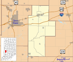
Location map of Clay County, Indiana.svg
Red pog.svg
Middlebury
Location in Clay County
Coordinates: 39°15′51″N87°07′08″W / 39.26417°N 87.11889°W / 39.26417; -87.11889 Coordinates: 39°15′51″N87°07′08″W / 39.26417°N 87.11889°W / 39.26417; -87.11889
Country United States
State Indiana
County Clay
Township Harrison
Elevation
669 ft (204 m)
GNIS feature ID439112 [1]

Middlebury is an unincorporated community in Harrison Township, Clay County, Indiana. It is part of the Terre Haute Metropolitan Statistical Area.
Contents

History

Middlebury was laid out in 1836. [2]

The only post office the community of Middlebury contained was called Martz. [3] It operated from 1854 until 1907. [4]

Geography

Middlebury is located at 39°15′51″N87°07′08″W / 39.26417°N 87.11889°W / 39.26417; -87.11889 .

Related Research Articles

Art, Indiana Unincorporated community in Indiana, United States

Art is an unincorporated community in Perry Township, Clay County, Indiana. It is part of the Terre Haute Metropolitan Statistical Area.

Ashboro is an unincorporated community in Sugar Ridge Township, Clay County, Indiana. It is part of the Terre Haute Metropolitan Statistical Area.

Asherville is an unincorporated community in Jackson Township, Clay County, Indiana. It is part of the Terre Haute Metropolitan Statistical Area.

Benwood is an unincorporated community in Van Buren Township, Clay County, Indiana, United States. It is part of the Terre Haute Metropolitan Statistical Area.

Billtown is an unincorporated community in Posey Township, Clay County, Indiana. It is part of the Terre Haute Metropolitan Statistical Area.

Bowling Green, Indiana Unincorporated community in Indiana, United States

Bowling Green is an unincorporated community in Washington Township, Clay County, Indiana. It is part of the Terre Haute Metropolitan Statistical Area.

Cardonia is an unincorporated community in Van Buren Township, Clay County, Indiana. It is part of the Terre Haute Metropolitan Statistical Area.

Coalmont, Indiana Census-designated place in Indiana, United States

Coalmont is an unincorporated community and census-designated place in Lewis Township, Clay County, Indiana, United States. It is part of the Terre Haute Metropolitan Statistical Area. As of the 2010 census it had a population of 402.

Hoosierville is an unincorporated community in Jackson Township, Clay County, Indiana. It is part of the Terre Haute Metropolitan Statistical Area.

Howesville is an unincorporated community in Lewis Township, Clay County, Indiana. It is part of the Terre Haute Metropolitan Statistical Area.

Perth is an unincorporated community in Dick Johnson Township, Clay County, Indiana. It is part of the Terre Haute Metropolitan Statistical Area.

Saline City, Indiana Unincorporated community in Indiana, United States

Saline City is an unincorporated community in Sugar Ridge Township, Clay County, Indiana. It is part of the Terre Haute Metropolitan Statistical Area.

Stearleyville is an unincorporated community in Jackson Township, Clay County, Indiana.

Pontiac is an unincorporated community in Van Buren Township, Clay County, Indiana. It is part of the Terre Haute Metropolitan Statistical Area.

Bogle Corner is an unincorporated community in Lewis Township, Clay County, Indiana. It is part of the Terre Haute Metropolitan Statistical Area.

Brunswick is an unincorporated community in Lewis Township, Clay County, Indiana. It is part of the Terre Haute Metropolitan Statistical Area.

Eel River is an unincorporated community in northern Harrison Township, Clay County, Indiana. It is part of the Terre Haute Metropolitan Statistical Area.

Calcutta is an unincorporated community in Clay County, Indiana, United States.

Mechanicsburg is an unincorporated community in Clay County, Indiana, in the United States.

Denmark is an unincorporated community in the southwest portion of Marion Township, Owen County, in the U.S. state of Indiana. It lies near the intersection of County Road 1400 West and County Road 150 South, which is a community about fifteen miles west of the city of Spencer, the county seat of Owen County. Its elevation is 722 feet, and it is located at 39°16′11″N87°1′33″W.

References

  1. "Middlebury, Indiana". Geographic Names Information System . United States Geological Survey . Retrieved 2009-10-10.
  2. Blanchard, Charles (1884). Counties of Clay and Owen, Indiana: Historical and Biographical. F.A. Battey & Company. pp.  203.
  3. Baker, Ronald L. (October 1995). From Needmore to Prosperity: Hoosier Place Names in Folklore and History . Indiana University Press. p.  218. ISBN   978-0-253-32866-3. ...it was called Martz, apparently for...
  4. "Clay County". Jim Forte Postal History. Retrieved 30 August 2014.