Clay City, Indiana | |
---|---|
Coordinates: 39°16′37″N87°6′43″W / 39.27694°N 87.11194°W | |
Country | United States |
State | Indiana |
County | Clay |
Township | Harrison |
Area | |
• Total | 0.54 sq mi (1.40 km2) |
• Land | 0.54 sq mi (1.40 km2) |
• Water | 0.00 sq mi (0.00 km2) |
Elevation | 594 ft (181 m) |
Population (2020) | |
• Total | 878 |
• Density | 1,628.94/sq mi (629.03/km2) |
Time zone | UTC-5 (EST) |
• Summer (DST) | UTC-5 (EST) |
ZIP code | 47841 |
Area code | 812 |
FIPS code | 18-13276 [2] |
GNIS feature ID | 0432585 [3] |
Website | http://www.claycity.net/ |
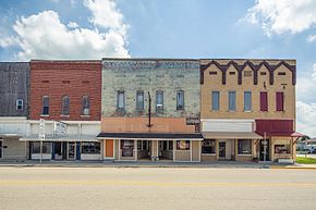
Clay City is a town in Harrison Township, Clay County, Indiana, United States. The population was 861 at the 2010 census. It is part of the Terre Haute Metropolitan Statistical Area.
Clay City was originally called Markland, and under the latter name was platted in 1873 when the railroad was extended to that point. [4]
It was originally called "Markland," but that name could not be used because another post office in Indiana used that name. The name "Huntersville" was adopted in honor of U.S. Congressman Morton C. Hunter. The Congressman was not popular in the local area, however, so residents objected to the name, and the name "Clay City" was eventually chosen by a local committee. [5] Clay City is named for Kentucky statesman Henry Clay. [6]
Clay City is located at 39°16′37″N87°6′43″W / 39.27694°N 87.11194°W (39.277048, -87.112079). [7]
According to the 2010 census, Clay City has a total area of 0.54 square miles (1.40 km2), all land. [8]
Census | Pop. | Note | %± |
---|---|---|---|
1880 | 419 | — | |
1890 | 1,004 | 139.6% | |
1900 | 1,503 | 49.7% | |
1910 | 1,213 | −19.3% | |
1920 | 1,226 | 1.1% | |
1930 | 1,079 | −12.0% | |
1940 | 1,117 | 3.5% | |
1950 | 1,068 | −4.4% | |
1960 | 950 | −11.0% | |
1970 | 900 | −5.3% | |
1980 | 883 | −1.9% | |
1990 | 929 | 5.2% | |
2000 | 1,019 | 9.7% | |
2010 | 861 | −15.5% | |
2020 | 878 | 2.0% | |
U.S. Decennial Census [9] |
As of the census [10] of 2010, there were 861 people, 361 households, and 241 families living in the town. The population density was 1,594.4 inhabitants per square mile (615.6/km2). There were 436 housing units at an average density of 807.4 per square mile (311.7/km2). The racial makeup of the town was 99.2% White, 0.1% Asian, and 0.7% from two or more races. Hispanic or Latino of any race were 0.7% of the population.
There were 361 households, of which 31.0% had children under the age of 18 living with them, 51.0% were married couples living together, 13.3% had a female householder with no husband present, 2.5% had a male householder with no wife present, and 33.2% were non-families. 29.6% of all households were made up of individuals, and 16.7% had someone living alone who was 65 years of age or older. The average household size was 2.39 and the average family size was 2.96.
The median age in the town was 39.2 years. 24.5% of residents were under the age of 18; 8% were between the ages of 18 and 24; 25% were from 25 to 44; 22.9% were from 45 to 64; and 19.6% were 65 years of age or older. The gender makeup of the town was 44.6% male and 55.4% female.
As of the census [2] of 2000, there were 1,019 people, 442 households, and 281 families living in the town. The population density was 1,906.9 inhabitants per square mile (736.3/km2). There were 473 housing units at an average density of 885.2 per square mile (341.8/km2). The racial makeup of the town was 98.92% White, 0.10% from other races, and 0.98% from two or more races. Hispanic or Latino of any race were 0.79% of the population.
There were 442 households, out of which 28.7% had children under the age of 18 living with them, 51.1% were married couples living together, 8.8% had a female householder with no husband present, and 36.2% were non-families. 33.0% of all households were made up of individuals, and 21.5% had someone living alone who was 65 years of age or older. The average household size was 2.31 and the average family size was 2.90.
In the town, the population was spread out, with 24.6% under the age of 18, 6.9% from 18 to 24, 28.1% from 25 to 44, 20.7% from 45 to 64, and 19.7% who were 65 years of age or older. The median age was 37 years. For every 100 females, there were 85.9 males. For every 100 females age 18 and over, there were 82.9 males.
The median income for a household in the town was $31,316, and the median income for a family was $36,750. Males had a median income of $31,324 versus $19,479 for females. The per capita income for the town was $15,281. About 5.3% of families and 8.9% of the population were below the poverty line, including 11.4% of those under age 18 and 10.2% of those age 65 or over.
Bentley is an incorporated town in southeast Hancock County, Illinois, United States. The population was 35 at the 2010 census.
Ulen is a town in Center Township, Boone County, in the U.S. state of Indiana. The population was 117 at the 2010 census. The town is surrounded by the city of Lebanon.
Brazil is a city in Clay County, Indiana, United States. The population was 8,176 at the 2022 census. The city is the county seat of Clay County. It is part of the Terre Haute Metropolitan Statistical Area.
Carbon is a town in Van Buren Township, Clay County, Indiana, United States. The population was 397 at the 2010 census. It is part of the Terre Haute Metropolitan Statistical Area.
Center Point is a town in Sugar Ridge Township, Clay County, Indiana, United States. The population was 242 at the 2010 census. It is part of the Terre Haute Metropolitan Statistical Area.
Staunton is a town in Posey Township, Clay County, Indiana, United States. The population was 534 at the 2010 census. It is part of the Terre Haute Metropolitan Statistical Area.
Plainville is a town in Steele Township, Daviess County, Indiana, United States. The population was 476 at the 2010 census. The former high school mascot was the Plainville Midgets.
Dillsboro is a town in Clay Township, Dearborn County, Indiana, United States. As of 2020, the population is 1,360.
Jasonville is a city in Greene County, Indiana, United States. The population was 1,966 as of the 2020 census. It is the westernmost community in the Bloomington, Indiana, Metropolitan Statistical Area, approximately 15 miles closer to Terre Haute than to Bloomington.
Country Club Heights is a town in Anderson Township, Madison County, Indiana, United States. The population was 98 at the 2020 census.
Spencer is a town in Washington Township, Owen County, in the U.S. state of Indiana. The population was 2,217 at the 2010 census. It is the county seat of Owen County.
Rockville is a town in Adams Township, Parke County, in the U.S. state of Indiana. The population was 2,607 at the 2010 census. The town is the county seat of Parke County. It is known as "The Covered Bridge Capital of the World".
Indian Village is a town in Clay Township, St. Joseph County, in the U.S. state of Indiana. The population was 133 at the 2010 Census. It is part of the South Bend–Mishawaka, IN-MI, Metropolitan Statistical Area.
Poneto is a town in Chester, Harrison and Liberty townships, Wells County, in the U.S. state of Indiana. The population was 166 at the 2010 census.
Marne is a city in Cass County, Iowa, United States. The population was 110 at the time of the 2020 census.
Silver City is a city in Mills County, Iowa, United States. The population was 245 at the 2020 census. The Wabash Trace—a railroad converted to a bicycle trail—passes through here. At trailside, there is a small park with a gazebo, and across from it, a small cafe.
Comstock is a city in Clay County, Minnesota, United States. The population was 100 at the 2020 census.
Calumet is a city in Itasca County, Minnesota, United States. The population was 367 at the 2010 census.
Clay is a town in and the county seat of Clay County, West Virginia, United States. The population was 399 at the 2020 census. It is the only incorporated town in Clay County.
Wynnedale is a town in Washington Township, Marion County, Indiana, United States. The population was 215 at the 2020 census. It has existed as an "included town" since 1970, when it was incorporated into Indianapolis as part of Unigov. It is part of Indianapolis, but retains a functioning town government under IC 36-3-1-11.