
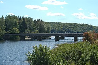
Turkey Run State Park, Indiana's second state park, is in Parke County in the west-central part of the state along State Road 47, 2 miles (3.2 km) east of U.S. 41.

The Beeson Covered Bridge originally crossed Roaring Creek, one mile (1.6 km) northwest of Marshall, Indiana, on County Road 216, in Washington Township, Parke County. The bridge was moved to its current location in Billie Creek Village in December 1979.

The Catlin Covered Bridge is a single span Burr Arch truss covered bridge structure that was built by Clark McDaniel in 1907.

The Thorpe Ford Covered Bridge is northeast of Rosedale, Indiana. The single span Burr Arch Truss covered bridge structure was built by Joseph A. Britton in 1912.

Washington Township is one of eleven townships in Clay County, Indiana. As of the 2020 census, its population was 750 and it contained 346 housing units.
Trunk Line Bridge No. 1, also known as Peshekee River Bridge, is a bridge adjacent to US Highway 41/M-28 (US 41/M-28). It was the first of many trunkline bridges designed by the Michigan State Highway Department. It was built in 1914, and listed on the National Register of Historic Places in 1999.

U.S. Route 64 is a U.S. route running from Teec Nos Pos, Arizona east to Nags Head, North Carolina. In the U.S. state of Arkansas, the route runs 246.35 miles (396.46 km) from the Oklahoma border in Fort Smith east to the Tennessee border in Memphis. The route passes through several cities and towns, including Fort Smith, Clarksville, Russellville, Conway, Searcy, and West Memphis. US 64 runs parallel to Interstate 40 (I-40) until Conway, when I-40 takes a more southerly route.
The New Harmony Toll Bridge, also known as the Harmony Way Bridge, is a now-closed two-lane bridge across the Wabash River that connects Illinois Route 14 with Indiana State Road 66, which is Church Street in New Harmony, Indiana. The bridge links White County, Illinois with Posey County, Indiana and carried U.S. Route 460 from 1947 until 1974 when the highway was decommissioned in Illinois and Indiana. The four-span bridge is owned by the White County Bridge Commission and was built without federal funds in 1930 by the Big Wabash Bridge Company of Carmi, Illinois. The next bridge across the Wabash about 15 miles (24 km) downstream is the Wabash Memorial Bridge near Mount Vernon, Indiana and the next bridge upstream is for Interstate 64, which does not allow farm vehicles.
The Vincennes Bridge Company, based in Vincennes, Indiana, was a designer and builder of bridges that was "one of Indiana's 'most successful bridge-building firms'".

The Lincoln Road–Pine River Bridge, also known as the Riverdale Bridge, was a bridge located on Lincoln Road over the Pine River near Seville, Michigan. The architect behind the Lincoln Road–Pine River Bridge was the Michigan State Highway Department and its builder was Walter Willets. The bridge is notable for being a large early example of an arched through girder bridge in Michigan, and for sitting on substantially skewed abutments. It was listed on the National Register of Historic Places in 1999.

Starke County Bridge No. 39 is a single span Warren Pony Truss structure. The bridge is located on the northern outskirts of the small town of Knox, Indiana, where Main and Water Streets terminate at the former Penn Central Railroad cut. The bridge spans the rail cut in a northwest–southeast direction, allowing access to Wythougan Park.

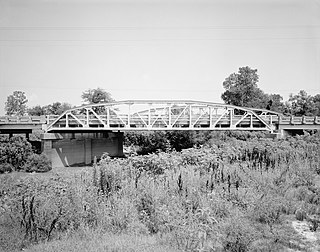
New Hope Bridge, also known as Bartholomew County Bridge No. 133, is a historic Pratt through truss bridge spanning the Flatrock River at Columbus Township, Bartholomew County, Indiana. It was designed by the Caldwell & Drake ironworks and built in 1913. It consists of two spans, with each measuring 128 feet long. It rests on concrete abutments and a concrete pier.

Pugh Ford Bridge, also known as Bartholomew County Bridge No. 73, is a historic Pratt through truss bridge spanning the Flatrock River at Flat Rock Township and German Township, Bartholomew County, Indiana. It was built by the Elkhart Bridge and Iron Co. and built in 1911. It consists of two spans, with each measuring 128 feet long. It rests on concrete abutments and a concrete pier.
Indiana State Highway Bridge 42-11-3101, also known as Poland Bridge, is a historic Parker through truss bridge located in Cass Township, Clay County, Indiana. It was built by the Vincennes Bridge Company and erected in 1939. It carries State Road 42 over the Eel River. It measures 175 feet long and rests on a concrete abutment and concrete pier.

Feeder Dam Bridge, also known as the Eel River Bridge and Clay County Bridge No. 208, is a historic Whipple through truss bridge located in Harrison Township and Sugar Ridge Township, Clay County, Indiana. It was built in 1894 and carries Towpath Road over the Eel River. It consists of a single 206-foot-long (63 m) span and rests on stone abutments.

County Bridge No. 45 is a historic Pratt Through Truss bridge located in Washington Township, Daviess County, Indiana. It was built by the Indiana Bridge Company and erected in 1903. It carries County Road 150N over the White River and into Knox County, Indiana. The bridge consists of three 140 foot long spans on concrete abutments, with an overall length of 422 feet.

Eikenberry Bridge, also known as Bridge 1–19, Lost Bridge, and Miami County Bridge #28, is a historic Pratt Through Truss bridge located in Richland Township, Miami County, Indiana. It was built about 1920 by the Rochester Bridge Company and spans the Eel River. It is a two-span metal truss bridge with an overall length of 227 feet.

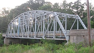
Smith Covered Bridge is a historic covered bridge located near Rushville, Indiana in Rushville Township, Rush County, Indiana. It was built in 1877 by A.M. Kennedy and his son Emmett. It is a Burr Arch bridge, 124 feet (38 m) long over Flatrock River. The bridge has rounded arch portals and decorative scrollwork that are signatures of the Kennedy firm.

4th Roann Covered Bridge is a historic Howe Truss covered bridge located in Paw Paw Township, Wabash County, Indiana. It was built in 1877 by the Smith Bridge Company of Toledo, Ohio and crosses the Eel River. It measures 288 feet long and is 15 feet, 4 inches wide. The bridge has painted board and batten siding.

North Manchester Covered Bridge is a historic Smith Type 4 Truss covered bridge located at North Manchester, Wabash County, Indiana. It was built in 1872 by the Smith Bridge Company of Toledo, Ohio and crosses the Eel River. It measures 150 feet long and is 18 feet wide. The bridge has painted board and batten siding.


