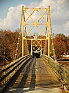
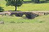
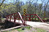
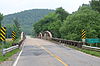
Name Image Built Listed Location County Type Amboy Overpass 1941 1995-05-18 North Little Rock 34°48′5″N 92°17′30″W / 34.80139°N 92.29167°W / 34.80139; -92.29167 (Amboy Overpass ) Pulaski AR 7/AR 51 Bridge 1933 2006-02-01 Arkadelphia 34°7′23″N 93°2′47″W / 34.12306°N 93.04639°W / 34.12306; -93.04639 (Arkansas 7/51 Bridge ) Clark Parker through truss AR 57 Bridge 1928, 1955 2005-09-28 Stephens 33°24′46″N 93°4′10″W / 33.41278°N 93.06944°W / 33.41278; -93.06944 (Arkansas Highway 57 Bridge ) Ouachita Parker pony truss AR 96 Bridge 1938 1995-05-05 Greenwood 35°13′8″N 94°13′16″W / 35.21889°N 94.22111°W / 35.21889; -94.22111 (State Highway 96 Bridge ) Sebastian Steel pony truss ; listed bridge has been demolished. AR 274 Bridge 1940 1995-05-18 Thornton 33°37′48″N 92°42′32″W / 33.63000°N 92.70889°W / 33.63000; -92.70889 (AR 274 Bridge ) Calhoun AR 289 Bridge Over English Creek 1929 2009-1-22 Mammoth Spring vicinity Fulton Beaver Bridge 1949 1990-04-09 Beaver 36°28′15″N 93°46′6″W / 36.47083°N 93.76833°W / 36.47083; -93.76833 (Beaver Bridge ) Carroll Suspension Big Botton Slough Bridge 1909 2004-09-24 Magness 35°40′19″N 91°28′38″W / 35.67194°N 91.47722°W / 35.67194; -91.47722 (Big Botton Slough Bridge ) Independence Pratt through truss Big Piney Creek Bridge 1931 1990-04-09 Hagersville 35°40′37″N 93°14′10″W / 35.67694°N 93.23611°W / 35.67694; -93.23611 (Big Piney Creek Bridge ) Johnson Warren through truss Buffalo River Bridge 1931 1990-04-09 Pruitt 36°3′38″N 93°8′18″W / 36.06056°N 93.13833°W / 36.06056; -93.13833 (Buffalo River Bridge ) Newton Pennsylvania through truss Cache River Bridge 1934 1990-04-09 Walnut Ridge 36°4′9″N 90°49′28″W / 36.06917°N 90.82444°W / 36.06917; -90.82444 (Cache River Bridge ) Lawrence Parker pony truss Cane Hill Road Bridge 1923 2010-01-21 Prairie Grove vicinity 36°0′1″N 94°16′30″W / 36.00028°N 94.27500°W / 36.00028; -94.27500 (Cane Hill Road Bridge ) Washington Closed-spandrel arch Cannon Creek Bridge 1929, 1954 2004-09-22 Cannon Creek 35°54′26″N 93°56′44″W / 35.90722°N 93.94556°W / 35.90722; -93.94556 (Cannon Creek Bridge ) Madison Reinforced concrete deck Cedar Creek Bridge (Rosie) 1941 1995-05-18 Rosie 35°38′34″N 91°32′26″W / 35.64278°N 91.54056°W / 35.64278; -91.54056 (Cedar Creek Bridge ) Independence Closed spandrel deck arch Cedar Creek Bridge (Petit Jean State Park) 1934 1990-04-09 Petit Jean State Park 35°7′43″N 92°55′30″W / 35.12861°N 92.92500°W / 35.12861; -92.92500 (Cedar Creek Bridge ) Conway Closed spandrel deck arch Central Avenue Bridge 1930 2010-01-21 Batesville Independence Coon Creek Bridge 1930, 1957 2007-01-24 Cherokee City 36°19′29″N 94°33′14″W / 36.32472°N 94.55389°W / 36.32472; -94.55389 (Coon Creek Bridge ) Benton Warren pony truss Coop Creek Bridge 1940 1995-05-05 Mansfield 35°3′27″N 94°14′10″W / 35.05750°N 94.23611°W / 35.05750; -94.23611 (Coop Creek Bridge ) Sebastian Open masonry substructure Cotter Bridge 1930 1990-04-04 Cotter 36°16′3″N 92°32′50″W / 36.26750°N 92.54722°W / 36.26750; -92.54722 (Cotter Bridge ) Baxter Rainbow arch Cotter Tunnel 1903, 1957 2007-09-19 Cotter 36°16′31″N 92°32′47″W / 36.27528°N 92.54639°W / 36.27528; -92.54639 (Cotter Tunnel ) Marion County Road 2E Bridge 1940 1995-05-05 Scotland 35°30′41″N 92°41′53″W / 35.51139°N 92.69806°W / 35.51139; -92.69806 (Van Buren County Road 2E Bridge ) Van Buren Open masonry substructure County Road 4G Bridge 1940 1995-05-05 West Hartford 34°59′25″N 94°25′7″W / 34.99028°N 94.41861°W / 34.99028; -94.41861 (Sebastian County Road 4G Bridge ) Sebastian Open masonry substructure County Road 5G Bridge 1943 1995-05-05 Hartford 35°0′57″N 94°23′37″W / 35.01583°N 94.39361°W / 35.01583; -94.39361 (Sebastian County Road 5G Bridge ) Sebastian Open masonry substructure; delisted in 2009 County Road 6 Bridge by 1915 2004-09-24 Cincinnati 36°4′15″N 94°28′30″W / 36.07083°N 94.47500°W / 36.07083; -94.47500 (County Road 6 Bridge ) Washington Warren pony truss County Road 513C Bridge 1942 1995-05-18 Dixie 35°55′12″N 90°25′23″W / 35.92000°N 90.42306°W / 35.92000; -90.42306 (Craighead County Road 513C Bridge ) Craighead Steel deck truss Cove Creek Bridge 1957 2004-05-24 Martinville 35°19′23″N 92°29′8″W / 35.32306°N 92.48556°W / 35.32306; -92.48556 (Cove Creek Bridge ) Conway Pratt through truss Cove Creek Bridge 1936 1995-05-26 Corley 35°11′35″N 93°37′24″W / 35.19306°N 93.62333°W / 35.19306; -93.62333 (Cove Creek Bridge ) Logan Masonry closed spandrel arch Cove Creek Tributary Bridge 1936 1995-05-26 Corley 35°14′31″N 93°38′22″W / 35.24194°N 93.63944°W / 35.24194; -93.63944 (Cove Creek Tributary Bridge ) Logan Masonry closed spandrel arch Cove Lake Spillway Dam-Bridge 1937 1995-09-11 Corley 35°13′58″N 93°37′45″W / 35.23278°N 93.62917°W / 35.23278; -93.62917 (Cove Lake Spillway Dam-Bridge ) Logan Rustic Cricket and Crest Tunnels Historic District 1903, 1957 2007-09-19 Omaha Boone Crooked Creek Bridge 1923 2010-01-21 Pyatt 36°14′54″N 92°50′37″W / 36.24833°N 92.84361°W / 36.24833; -92.84361 (Crooked Creek Bridge ) Marion Crowley's Ridge State Park-Bridge ca. 1935 1992-05-28 Walcott 36°2′42″N 90°39′47″W / 36.04500°N 90.66306°W / 36.04500; -90.66306 (Crowley's Ridge State Park-Bridge ) Greene DeGray Creek Bridge 1915 2010-01-21 Arkadelphia Clark Edgemere Street Bridge 1930s 1990-04-09 North Little Rock 34°47′40″N 92°15′0″W / 34.79444°N 92.25000°W / 34.79444; -92.25000 (Edgemere Street Bridge ) Pulaski Closed spandrel deck arch Evansville-Dutch Mills Road Bridge 1936 2008-01-24 Dutch Mills 35°51′55″N 94°29′59″W / 35.86528°N 94.49972°W / 35.86528; -94.49972 (Evansville-Dutch Mills Road Bridge ) Washington Closed spandrel concrete arch Fourche LaFave River Bridge 1941 1995-05-26 Nimrod 34°57′7″N 93°9′8″W / 34.95194°N 93.15222°W / 34.95194; -93.15222 (Fourche LaFave River Bridge ) Perry Open masonry Frog Bayou Bridge 1942 1995-05-26 Mountainburg 35°37′4″N 94°11′3″W / 35.61778°N 94.18417°W / 35.61778; -94.18417 (Frog Bayou Bridge ) Crawford Parker through truss Goff Farm Stone Bridge c. 1860 2010-01-21 Fayetteville vicinity Washington Hackett Creek Bridge 1941 1995-05-05 Hackett 35°11′35″N 94°24′51″W / 35.19306°N 94.41417°W / 35.19306; -94.41417 (Hackett Creek Bridge ) Sebastian Open masonry substructure Haggard Ford Swinging Bridge ca. 1938 1995-06-30 Harrison 36°20′45″N 93°7′50″W / 36.34583°N 93.13056°W / 36.34583; -93.13056 (Haggard Ford Swinging Bridge ) Boone Suspension Hale Creek Bridge 1919 2004-05-26 Red Wing 34°4′47″N 94°11′9″W / 34.07972°N 94.18583°W / 34.07972; -94.18583 (Hale Creek Bridge ) Sevier Pratt pony truss Harp Creek Bridge 1928 1990-04-09 Jasper 36°4′58″N 93°8′14″W / 36.08278°N 93.13722°W / 36.08278; -93.13722 (Harp Creek Bridge ) Newton Open spandrel deck arch Highway B-1, Little Telico Creek Bridge ca. 1918 2009-5-20 SFC 213 Rd. over Little Telico Creek 35°3′56.72″N 90°48′57.32″W / 35.0657556°N 90.8159222°W / 35.0657556; -90.8159222 (Highway B-1, Little Telico Creek Bridge ) St. Francis Highway B-29 Bridge 1923 2008-9-24 Prairie Grove 35°59′41.98″N 94°17′53.4″W / 35.9949944°N 94.298167°W / 35.9949944; -94.298167 (Highway B-29 Bridge ) Washington Illinois River Bridge 1922 2005-01-19 Pedro 36°10′39″N 94°23′31″W / 36.17750°N 94.39194°W / 36.17750; -94.39194 (Illinois River Bridge ) Benton Pratt through truss Illinois River Bridge 1926 20098-01-22 Savoy 36°9′59″N 94°26′1″W / 36.16639°N 94.43361°W / 36.16639; -94.43361 (Illinois River Bridge ) Washington Illinois River Bridge at Phillips Ford 1922 1988-01-28 County Road 848 over the Illinois River 36°8′6.24″N 94°21′29.12″W / 36.1350667°N 94.3580889°W / 36.1350667; -94.3580889 (Illinois River Bridge at Phillips Ford ) Washington Closed-spandrel arch Judsonia Bridge 1924 1990-04-09 Judsonia 35°16′3″N 91°38′23″W / 35.26750°N 91.63972°W / 35.26750; -91.63972 (Judsonia Bridge ) White Warren swing through truss Lafayette Street Overpass 1938 1995-05-26 Fayetteville 36°4′6″N 94°9′57″W / 36.06833°N 94.16583°W / 36.06833; -94.16583 (Lafayette Street Overpass ) Washington Open masonry Lake Catherine State Park-Bridge No. 2 ca. 1935 1992-05-28 Shorewood Hills 34°25′46″N 92°56′21″W / 34.42944°N 92.93917°W / 34.42944; -92.93917 (Lake Catherine State Park-Bridge No. 2 ) Hot Spring Lake No. 1 Bridge 1920s 1990-04-09 North Little Rock 34°47′20″N 92°15′8″W / 34.78889°N 92.25222°W / 34.78889; -92.25222 (Lake No. 1 Bridge ) Pulaski Closed spandrel deck arch Lakeshore Drive Bridge 1930s 1990-04-09 North Little Rock 34°47′41″N 92°15′6″W / 34.79472°N 92.25167°W / 34.79472; -92.25167 (Lakeshore Drive Bridge ) Pulaski Closed spandrel deck arch Ben Laney Bridge 1947 2000-06-09 Camden 33°35′47″N 92°49′7″W / 33.59639°N 92.81861°W / 33.59639; -92.81861 (Ben Laney Bridge ) Ouachita Pratt pony truss Lee Creek Bridge 1934 1990-04-06 Natural Dam 35°38′46″N 94°23′37″W / 35.64611°N 94.39361°W / 35.64611; -94.39361 (Lee Creek Bridge (Natural Dam) ) Crawford Pennsylvania through truss Lee Creek Bridge 1934 2010-01-21 Van Buren 35°27′58″N 94°23′22″W / 35.46611°N 94.38944°W / 35.46611; -94.38944 (Lee Creek Bridge (Van Buren) ) Crawford Multi-span Pratt and Warren truss bridge. Lincoln Avenue Viaduct 1928 1990-04-09 Little Rock 34°45′9″N 92°16′59″W / 34.75250°N 92.28306°W / 34.75250; -92.28306 (Lincoln Avenue Viaduct ) Pulaski Rainbow arch Little Buffalo River Bridge 1939 1995-05-26 Parthenon 35°58′7″N 93°13′37″W / 35.96861°N 93.22694°W / 35.96861; -93.22694 (Little Buffalo River Bridge ) Newton Open masonry Little Cossatot River Bridge 1908 1990-04-06 Lockesburg 33°58′29″N 94°12′18″W / 33.97472°N 94.20500°W / 33.97472; -94.20500 (Little Cossatot River Bridge ) Sevier Warren pony truss Little Cypress Creek Bridge 1942 1995-05-18 Postelle 34°33′27″N 91°1′24″W / 34.55750°N 91.02333°W / 34.55750; -91.02333 (Little Cypress Creek Bridge ) Phillips Little Missouri River Bridge 1910 1990-04-09 Prescott 33°54′10″N 93°18′35″W / 33.90278°N 93.30972°W / 33.90278; -93.30972 (Little Missouri River Bridge ) Clark Camelback Pratt Main Street Bridge 1922 2002-07-11 New Blaine 35°17′19″N 93°25′13″W / 35.28861°N 93.42028°W / 35.28861; -93.42028 (Main Street Bridge ) Logan Masonry closed spandrel arch Maple Street Overpass 1936 1995-05-26 Fayetteville 36°4′12″N 94°10′0″W / 36.07000°N 94.16667°W / 36.07000; -94.16667 (Maple Street Overpass ) Washington Open masonry Marr's Creek Bridge 1934 2008-01-24 Pocahontas 36°15′35″N 90°58′19″W / 36.25972°N 90.97194°W / 36.25972; -90.97194 (Marr's Creek Bridge ) Randolph Spandrel arch Maxwell Street Bridge c. 1910 2011-4-8 DeWitt 34°17′51″N 91°20′15″W / 34.29750°N 91.33750°W / 34.29750; -91.33750 (Maxwell Street Bridge ) Arkansas McNeely Creek Bridge 1923 2004-05-26 Beirne 33°53′20″N 93°12′34″W / 33.88889°N 93.20944°W / 33.88889; -93.20944 (McNeely Creek Bridge ) Clark Warren pony truss Memphis & Arkansas Bridge 1949 2001-02-16 West Memphis 35°7′39″N 90°4′32.4″W / 35.12750°N 90.075667°W / 35.12750; -90.075667 (Memphis & Arkansas Bridge ) Crittenden Warren truss with verticals Mickles Bridge 1880 2007-08-16, delisted 2014-05-27 Mickles 35°4′27″N 93°17′51″W / 35.07417°N 93.29750°W / 35.07417; -93.29750 (Mickles Bridge ) Yell Bowstring through truss Middle Fork of the Little Red River Bridge 1908 2010-01-21 Shirley Van Buren Miller Creek Bridge 1914 2010-01-21 Batesville Independence Milltown Bridge 1930s 1990-04-06 Milltown 35°9′30″N 94°10′26″W / 35.15833°N 94.17389°W / 35.15833; -94.17389 (Milltown Bridge ) Sebastian Closed spandrel deck arch Mountain Fork Bridge 1990-04-09 Mena 34°31′41″N 94°24′0″W / 34.52806°N 94.40000°W / 34.52806; -94.40000 (Mountain Fork Bridge ) Polk Pratt pony truss Mulberry River Bridge 1927, 1957 2007-01-24 Pleasant Hill 35°31′57″N 94°2′27″W / 35.53250°N 94.04083°W / 35.53250; -94.04083 (Mulberry River Bridge ) Crawford , Franklin Pratt through truss Mulberry River Bridge 1935 2007-01-24 Turner's Bend 35°40′18″N 93°49′46″W / 35.67167°N 93.82944°W / 35.67167; -93.82944 (Mulberry River Bridge ) Franklin Parker pony truss Mulladay Hollow Bridge 1990-04-06 Eureka Springs 36°26′6″N 93°45′56″W / 36.43500°N 93.76556°W / 36.43500; -93.76556 (Mulladay Hollow Bridge ) Carroll Closed spandrel deck arch Newport Bridge 1930 1990-04-09 Newport 35°36′5″N 91°17′16″W / 35.60139°N 91.28778°W / 35.60139; -91.28778 (Newport Bridge ) Jackson Warren cantilever North Fork Bridge 1937 1990-04-09 Norfork 36°12′44″N 92°17′10″W / 36.21222°N 92.28611°W / 36.21222; -92.28611 (North Fork Bridge ) Baxter Warren deck truss ; demolished in 2014. North Fork Saline River Bridge 1944 1995-05-26 Paron 34°46′47″N 92°45′28″W / 34.77972°N 92.75778°W / 34.77972; -92.75778 (North Fork Saline River Bridge ) Saline Open masonry North Jackson Street Bridge c. 1910 2011-4-8 DeWitt 34°17′51″N 91°20′29″W / 34.29750°N 91.34139°W / 34.29750; -91.34139 (North Jackson Street Bridge ) Arkansas Early (c. 1910s) concrete deck bridge. North Washington Street Bridge 1910, 1942 2014-1-22 DeWitt 34°18′2″N 91°20′0″W / 34.30056°N 91.33333°W / 34.30056; -91.33333 (North Washington Street Bridge ) Arkansas Early (1910) concrete deck bridge. North Sylamore Creek Bridge 2010-02-24 Fifty-Six 35°59′44″N 92°12′46″W / 35.99556°N 92.21278°W / 35.99556; -92.21278 (North Sylamore Creek Bridge ) Stone Old Benton-Sardis Road Bridge ca. 1919, ca. 1945 2007-01-24 Bauxite 34°33′39″N 92°30′11″W / 34.56083°N 92.50306°W / 34.56083; -92.50306 (Old Benton-Sardis Road Bridge ) Saline Concrete deck truss Old AR 16 Bridge 1936 2011-5-11 Edgemont vicinity 35°36′9″N 92°11′18″W / 35.60250°N 92.18833°W / 35.60250; -92.18833 (Old AR 16 Bridge ) Cleburne Old River Bridge 1889 1977-09-15 Benton 34°32′26″N 92°36′25″W / 34.54056°N 92.60694°W / 34.54056; -92.60694 (Old River Bridge ) Saline Osage Creek Bridge 1911 1988-01-28 Tontitown 36°14′26″N 94°15′12″W / 36.24056°N 94.25333°W / 36.24056; -94.25333 (Osage Creek Bridge ) Benton Pratt through truss Petit Jean River Bridge 1938 1995-05-26 Sugar Grove 35°5′48″N 93°48′3″W / 35.09667°N 93.80083°W / 35.09667; -93.80083 (Petit Jean River Bridge ) Logan Pratt through truss Petit Jean River Bridge 1930 2010-01-21 Ola vicinity Yell Petit Jean State Park-Concrete Log Bridge ca. 1935 1992-05-28 Winrock 35°7′34″N 92°55′29″W / 35.12611°N 92.92472°W / 35.12611; -92.92472 (Petit Jean State Park-Concrete Log Bridge ) Conway Rustic Petit Jean State Park-Culvert No. 1 ca. 1935 1992-05-28 Winrock 35°7′5″N 92°55′58″W / 35.11806°N 92.93278°W / 35.11806; -92.93278 (Petit Jean State Park-Culvert No. 1 ) Conway Rustic Pyatt Tunnel 1903, 1957 2007-09-19 Pyatt 36°14′31″N 92°49′17″W / 36.24194°N 92.82139°W / 36.24194; -92.82139 (Pyatt Tunnel ) Marion Sanitarium Lake Bridges Historic District 1891 2010-01-19 Eureka Springs 36°22′47″N 93°44′4″W / 36.37972°N 93.73444°W / 36.37972; -93.73444 (Sanitarium Lake Bridges Historic District ) Carroll Two stone arch bridges. Self Creek Bridge 1949 2000-06-09 Daisy 34°14′11″N 93°45′24″W / 34.23639°N 93.75667°W / 34.23639; -93.75667 (Self Creek Bridge ) Pike Open spandrel deck arch Shady Lake CCC Bridge No. 1 1937 2010-10-14 Athens vicinity 34°21′39″N 94°01′24″W / 34.36083°N 94.02333°W / 34.36083; -94.02333 (Shady Lake CCC Bridge #1 ) Polk Stone arch Shady Lake CCC Bridge No. 2 1937 2010-10-14 Athens vicinity 34°22′04″N 94°01′31″W / 34.36778°N 94.02528°W / 34.36778; -94.02528 (Shady Lake CCC Bridge #2 ) Polk Stone arch Short Mountain Creek Bridge 1928, 1954 2004-09-24 Paris 35°18′41″N 93°44′37″W / 35.31139°N 93.74361°W / 35.31139; -93.74361 (Short Mountain Creek Bridge ) Logan Parker pony truss South Fork Bridge 1928 1990-04-09 Fountain Lake 34°36′11″N 92°55′20″W / 34.60306°N 92.92222°W / 34.60306; -92.92222 (South Fork Bridge ) Garland Closed spandrel deck arch South Fourche LaFave River Bridge 1933, 1954 2004-09-24 Hollis 34°52′22″N 93°6′38″W / 34.87278°N 93.11056°W / 34.87278; -93.11056 (South Fourche LaFave River Bridge ) Perry Parker pony truss Spring Lake Bridge 1936 1990-06-21 Belleville 35°9′4″N 93°25′54″W / 35.15111°N 93.43167°W / 35.15111; -93.43167 (Spring Lake Bridge ) Yell Closed spandrel deck arch Spring River Bridge 1916 2014-01-22 Mammoth Spring 36°28′38″N 91°31′28″W / 36.47722°N 91.52444°W / 36.47722; -91.52444 (Spring River Bridge ) Fulton Concrete deck girder Springfield Bridge 1891, 1874 1988-07-21 Springfield 35°15′9″N 92°30′45″W / 35.25250°N 92.51250°W / 35.25250; -92.51250 (Springfield Bridge ) Faulkner Tubular bowstring arch St. Francis River Bridge 1934 1990-04-09 Lake City 35°49′14″N 90°25′58″W / 35.82056°N 90.43278°W / 35.82056; -90.43278 (St. Francis River Bridge ) Craighead I-beam vertical lift ; dismantled in 1998, leaving only the vertical lift span St. Francis River Bridge 1933 1990-04-09 Madison 35°2′13″N 90°42′37″W / 35.03694°N 90.71028°W / 35.03694; -90.71028 (St. Francis River Bridge ) St. Francis Swing through truss St. Louis-San Francisco Overpass 1937 1990-04-09 Imboden 36°12′24″N 91°10′17″W / 36.20667°N 91.17139°W / 36.20667; -91.17139 (St. Louis-San Francisco Overpass ) Lawrence Pratt deck truss Sylamore Creek Bridge 1945 1999-11-18 Allison 35°56′9″N 92°7′18″W / 35.93583°N 92.12167°W / 35.93583; -92.12167 (Sylamore Creek Bridge ) Stone Wire-cable suspension Twin Bridges Historic District 1994-03-07 Morrow 35°52′35″N 94°27′12″W / 35.87639°N 94.45333°W / 35.87639; -94.45333 (Twin Bridges Historic District ) Washington U.S. 62 White River Bridge 1950, 1958 2008-01-24 Eureka Springs 36°27′4″N 93°49′24″W / 36.45111°N 93.82333°W / 36.45111; -93.82333 (U.S. 62 White River Bridge ) Carroll Deck truss US 62 Bridge over Crooked Creek 1948 2000-06-09 Pyatt 36°14′45″N 92°50′4″W / 36.24583°N 92.83444°W / 36.24583; -92.83444 (US 62 Bridge over Crooked Creek ) Marion Warren truss with verticals US 63 Black River Bridge 1949 2000-06-09 Black Rock 36°5′52″N 91°5′32″W / 36.09778°N 91.09222°W / 36.09778; -91.09222 (US 63 Black River Bridge ) Lawrence Warren truss U.S. 64 Horsehead Creek Bridge 1933 2014-09-29 Hartman 35°26′6″N 93°36′22″W / 35.43500°N 93.60611°W / 35.43500; -93.60611 (US 64 Horsehead Creek Bridge ) Johnson US 67 Bridge over Little Missouri River 1931, 1957 2007-01-24 Prescott 33°52′48″N 93°18′16″W / 33.88000°N 93.30444°W / 33.88000; -93.30444 (US 67 Bridge over Little Missouri River ) Clark Parker pony truss Wallace Bridge 1908 2008-8-1 Perry Camelback through truss War Eagle Bridge 1907 1985-11-19 War Eagle 36°16′2″N 93°56′35″W / 36.26722°N 93.94306°W / 36.26722; -93.94306 (War Eagle Bridge ) Benton Parker through truss War Eagle Creek Bridge 1925, 1958 2008-01-24 Old Alabam 36°7′24″N 93°41′39″W / 36.12333°N 93.69417°W / 36.12333; -93.69417 (War Eagle Creek Bridge ) Madison Open spandrel arch Ward's Crossing Bridge 1905 2008-06-4 Plainview Yell Camelback through-truss Warrens Bridge 1930 1995-05-18 Lambrook 34°20′9″N 91°0′42″W / 34.33583°N 91.01167°W / 34.33583; -91.01167 (Warrens Bridge ) Phillips Timber trestle Woolsey Bridge (Washington County Road 35 Bridge) 1925 2000-06-09 Woolsey 35°53′1″N 94°9′53″W / 35.88361°N 94.16472°W / 35.88361; -94.16472 (Washington County Road 35 Bridge ) Washington Camelback truss Waterside Street Bridge ca. 1935 1990-06-14 North Little Rock 34°46′59″N 92°14′46″W / 34.78306°N 92.24611°W / 34.78306; -92.24611 (Waterside Street Bridge ) Pulaski Closed spandrel masonry deck West James Street Overpass 1924 1995-05-18 Redfield 34°26′44″N 92°11′6″W / 34.44556°N 92.18500°W / 34.44556; -92.18500 (West James Street Overpass ) Jefferson White River Bridge 1930, 1931 1984-11-01 Clarendon 34°41′22″N 91°19′1″W / 34.68944°N 91.31694°W / 34.68944; -91.31694 (Highway 79 Bridge ) Monroe Warren truss Demolished November 2019 [2]
White River Bridge at Elkins 1921 2008-01-24 Elkins 36°0′10″N 94°0′14″W / 36.00278°N 94.00389°W / 36.00278; -94.00389 (White River Bridge at Elkins ) Washington Closed spandrel arch Zinc Swinging Bridge-BO0162 1927, 1957 2007-01-24 Zinc 36°17′5″N 92°54′55″W / 36.28472°N 92.91528°W / 36.28472; -92.91528 (Zinc Swinging Bridge-BO0162 ) Boone Wire-cable suspension Achmun Creek Bridge ca. 1920 Ola Yell Warren pony truss Augusta Bridge 1930 Augusta Woodruff Warren cantilever Big Slough Ditch Bridge 1947 Brighton Greene Warren truss Black River Bridge 1934 listed 1990-04-09; removed 2018-01-26 Pocahontas 36°14′56″N 90°58′2″W / 36.24889°N 90.96722°W / 36.24889; -90.96722 (Black River Bridge ) Randolph Warren swing through truss Cedar Creek Bridge 1938 Rudy Crawford Pratt through truss Crawford County Road 32D Bridge 1937 Natural Dam Crawford Steel multi-beam Cypress Creek Bridge ca. 1915 Perry Perry Pratt through truss Eight Mile Creek Bridge 1929 Paragould Greene Pratt pony truss Galla Creek Bridge 1920 Pottsville Pope Pratt through truss Jenny Lind Bridge ca. 1940 Jenny Lind Sebastian Closed spandrel deck arch Lee Creek Bridge (Cove City, Arkansas) Cove City Crawford Pennsylvania through truss Old Rockport Bridge 1900 Rockport Hot Spring Ouachita River Bridge 1930 Calion Union Parker through truss Pulaski County Road 67D Bridge 1939 Jacksonville Pulaski Open masonry Pulaski County Road 71D Bridge 1939 Jacksonville Pulaski Open masonry Red River Bridge 1931 Garland City Miller Pennsylvania through truss Saline River Bridge 1928 Benton Saline Open spandrel deck arch Second Street Bridge 1915 Little Rock Pulaski Rainbow arch Solgohachia Bridge 1890, 1891 2004-05-26 Solgohachia 35°16′17″N 92°42′48″W / 35.27139°N 92.71333°W / 35.27139; -92.71333 (Solgohachia Bridge ) Conway Pratt through truss Spavinaw Creek Bridge 1909 Decatur Benton Truss leg bedstead pony Vache Grasse Creek Bridge 1940 Milltown Sebastian Stone masonry closed spandrel Washington County Road 80F Bridge 1940 Viney Grove Washington Steel pony truss White River Bridge at DeValls Bluff 1924 De Valls Bluff Prairie Pratt through truss Winkley Bridge 1912 Heber Springs Cleburne Wolf Bayou Bridge 1924 Scott Pulaski Warren pony truss Wyman Bridge 1908 Fayetteville Washington Parker through truss