Pottsville, Arkansas

Last updated

Pottsville, Arkansas
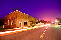
ChrisLitherlandPottsville.jpg
"Downtown" Pottsville
Pope County Arkansas Incorporated and Unincorporated areas Pottsville Highlighted 0556990.svg
Location of Pottsville in Pope County, Arkansas.
Coordinates: 35°14′56″N93°03′49″W / 35.24889°N 93.06361°W / 35.24889; -93.06361
Country United States
State Arkansas
County Pope
Area
[1]
  Total13.56 sq mi (35.11 km2)
  Land13.53 sq mi (35.05 km2)
  Water0.02 sq mi (0.06 km2)
Elevation
[2]
387 ft (118 m)
Population
 (2020)
  Total3,140
  Density232.04/sq mi (89.59/km2)
Time zone UTC-6 (Central (CST))
  Summer (DST) UTC-5 (CDT)
ZIP code
72858
Area code 479
FIPS code 05-56990
GNIS feature ID2404563 [2]
Website cityofpottsville.com

Pottsville is a city [3] in Pope County, Arkansas, United States. As of the 2020 census the population was 3,140. It is part of the Russellville Micropolitan Statistical Area.

Contents

Geography

Pottsville is surrounded by Russellville to the west, Atkins to the east, and Crow Mountain to the north.

According to the United States Census Bureau, the town has a total area of 7.5 square miles (19 km2), of which 7.5 square miles (19 km2) is land and 0.04 square miles (0.10 km2) (0.27%) is water.

Demographics

Historical population
CensusPop.Note
1900 192
1910 2056.8%
1920 27534.1%
1930 2936.5%
1940 3085.1%
1950 224−27.3%
1960 25011.6%
1970 41164.4%
1980 56437.2%
1990 98474.5%
2000 1,27129.2%
2010 2,838123.3%
2020 3,14010.6%
U.S. Decennial Census [4]

2020 census

Pottsville racial composition [5]
RaceNumberPercentage
White (non-Hispanic)2,61083.12%
Black or African American (non-Hispanic)180.57%
Native American 260.83%
Asian 300.96%
Other/Mixed 1494.75%
Hispanic or Latino 3079.78%

As of the 2020 United States census, there were 3,140 people, 1,031 households, and 840 families residing in the city.

2000 census

As of the 2000 census the population stood at 1,271, with 475 households and 372 families in the town. The population density was 169.3 inhabitants per square mile (65.4/km2). There were 500 housing units at an average density of 66.6 per square mile (25.7/km2). The racial makeup of the town was 95.67% White, 0.79% Black or African American, 0.71% Native American, 0.79% Asian, 0.16% from other races, and 1.89% from two or more races. 0.55% of the population were Hispanic or Latino of any race.

Of the 475 households 38.1% had children under the age of 18 living with them, 63.4% were married couples living together, 9.1% had a female householder with no husband present, and 21.5% were non-families. 18.1% of households were one person and 8.8% were one person aged 65 or older. The average household size was 2.68 and the average family size was 3.02.

The age distribution was 26.8% under the age of 18, 7.6% from 18 to 24, 31.2% from 25 to 44, 22.5% from 45 to 64, and 11.9% 65 or older. The median age was 36 years. For every 100 females, there were 100.2 males. For every 100 females age 18 and over, there were 99.8 males.

The median household income was $32,841 and the median family income was $37,763. Males had a median income of $27,237 versus $18,625 for females. The per capita income for the town was $15,066. About 12.6% of families and 16.7% of the population were below the poverty line, including 27.8% of those under age 18 and 10.0% of those age 65 or over.
Related Research Articles

<span class="mw-page-title-main">Franklin County, Alabama</span> County in Alabama, United States

Franklin County is a county located in the U.S. state of Alabama. As of the 2020 census, the population was 32,113. Its county seat is Russellville. Its name is in honor of Benjamin Franklin, famous statesman, scientist, and printer. It is a dry county, although the city of Russellville is wet.

<span class="mw-page-title-main">Bear Creek, Alabama</span> Town in Alabama, United States

Bear Creek is a town in Marion County, Alabama, United States. It incorporated in 1907, although the 1910 U.S. Census records indicated 1909. At the 2020 census, the population was 1,047.

<span class="mw-page-title-main">Lake View, Alabama</span> City in Alabama, United States

Lake View is a city in Tuscaloosa County, Alabama, United States. At the 2010 census the population was 1,943, up from 1,357 in 2000. It is part of the Tuscaloosa, Alabama Metropolitan Statistical Area. It is located approximately halfway between Tuscaloosa and Birmingham via Interstates 20 and 59.

<span class="mw-page-title-main">Brookland, Arkansas</span> City in Arkansas, United States

Brookland is a city in Craighead County, Arkansas, United States. The population was 1,642 at the 2010 census. It is included in the Jonesboro, Arkansas Metropolitan Statistical Area.

<span class="mw-page-title-main">Arkansas City, Arkansas</span> Town in Arkansas, United States

Arkansas City is a town in Desha County, Arkansas, United States. The population was 366 at the 2010 census. The town is the county seat of Desha County. Arkansas City's historic Commercial District, located at Desoto Avenue and Sprague Street, is listed on the National Register of Historic Places.

<span class="mw-page-title-main">Lamar, Arkansas</span> City in Arkansas, United States

Lamar is a city in Johnson County, Arkansas, United States. The population was 1,605 at the 2010 census, up from 1,415 at the 2000 census.

<span class="mw-page-title-main">Bluff City, Arkansas</span> Town in Arkansas, United States

Bluff City is an unincorporated town in Nevada County, Arkansas, United States. The population was 158 at the 2000 census. It is part of the Hope Micropolitan Statistical Area.

<span class="mw-page-title-main">Atkins, Arkansas</span> City in Arkansas, United States

Atkins is a city in Pope County, Arkansas, United States. The population was 3,016 at the 2010 census. It is part of the Russellville Micropolitan Statistical Area.

<span class="mw-page-title-main">London, Arkansas</span> City in Arkansas, United States

London is a city in Pope County, Arkansas, United States. The population was 1,039 at the 2010 census. It is part of the Russellville Micropolitan Statistical Area.

<span class="mw-page-title-main">Belleville, Arkansas</span> City in Arkansas, United States

Belleville is a city in Yell County, Arkansas, United States. The population was 441 at the 2010 census. It is part of the Russellville Micropolitan Statistical Area.

<span class="mw-page-title-main">Danville, Arkansas</span> City in Arkansas, United States

Danville is a city in Yell County, Arkansas, United States. The population was 2,409 at the 2010 census. Along with Dardanelle, it is one of two county seats for Yell County.

<span class="mw-page-title-main">Havana, Arkansas</span> City in Arkansas, United States

Havana is a city in northwest Yell County, Arkansas, United States. The population was 375 at the 2010 census. It is part of the Russellville Micropolitan Statistical Area. Arkansas Scenic State Highway 309 leads from Havana to the top of Mount Magazine, home of Arkansas's newest State Park, and the highest peak in Arkansas.

<span class="mw-page-title-main">Ola, Arkansas</span> City in Arkansas, United States

Ola is a city in Yell County, Arkansas, United States. The population was 1,281 at the 2010 census. It is roughly 15 miles south of the Russellville Metropolitan area.

<span class="mw-page-title-main">Russellville, Indiana</span> Town in Indiana, United States

Russellville is a town in Russell Township, Putnam County, in the U.S. state of Indiana. The population was 358 at the 2010 census.

<span class="mw-page-title-main">Russellville, Missouri</span> City in Missouri, United States

Russellville is a city in Cole County, Missouri, United States. The population was 778 at the 2020 census. It is part of the Jefferson City, Missouri Metropolitan Statistical Area.

<span class="mw-page-title-main">Russellville, Ohio</span> Village in Ohio, United States

Russellville is a village in Jefferson Township, Brown County, Ohio, United States. The population was 542 at the 2020 census.

Dwight Mission is a census-designated place (CDP) in Sequoyah County, Oklahoma, United States. It is part of the Fort Smith, Arkansas-Oklahoma Metropolitan Statistical Area. The population was 55 at the 2010 census, a 71.9 percent gain over the figure of 32 recorded in 2000. It is currently the home of Dwight Mission Presbyterian Camp & Retreat Center.

<span class="mw-page-title-main">Kline Township, Schuylkill County, Pennsylvania</span> Township in Pennsylvania, United States

Kline Township is a township in Schuylkill County, Pennsylvania. The population was 1,473 at the 2020 census.

<span class="mw-page-title-main">Mason, West Virginia</span> Town in West Virginia, United States

Mason, also known as Mason City, is a town in Mason County, West Virginia, United States. The population was 865 at the 2020 census. It is part of the Point Pleasant, WV–OH Micropolitan Statistical Area.

<span class="mw-page-title-main">Gibraltar, Wisconsin</span> Town in Wisconsin, United States

Gibraltar is a town in Door County, Wisconsin, United States. The population was 1,228 at the 2020 census. The unincorporated communities of Fish Creek and Juddville are located in the town.

References

  1. "2020 U.S. Gazetteer Files". United States Census Bureau. Retrieved October 29, 2021.
  2. 1 2 U.S. Geological Survey Geographic Names Information System: Pottsville, Arkansas
  3. Local.Arkansas.gov - Pottsville , retrieved September 3, 2012
  4. "Census of Population and Housing". Census.gov. Retrieved June 4, 2015.
  5. "Explore Census Data". data.census.gov. Retrieved January 1, 2022.