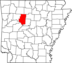
Walnut Grove, Pope County, Arkansas

Last updated

Walnut Grove, Arkansas
USA Arkansas location map.svg
Red pog.svg
Walnut Grove, Arkansas
Walnut Grove's position in Arkansas
Coordinates: 35°28′29″N92°56′21″W / 35.47472°N 92.93917°W / 35.47472; -92.93917
Country Flag of the United States.svg  United States
State Flag of Arkansas.svg  Arkansas
County Pope
Township Jackson
Elevation
[1]
214 m (702 ft)
Time zone UTC-6 (Central (CST))
  Summer (DST) UTC-5 (CDT)
ZIP code
72843
Area code 479
GNIS feature ID62057 [1]

Walnut Grove was an unincorporated community in Jackson Township, Pope County, Arkansas, United States. [1] It was located on Walnut Grove Road, east of Hector. The Walnut Grove cemetery and church are approximately one mile apart at the location indicated with the cemetery adjacent to Dare Creek and the church on a hilltop one mile to the south. [2]

Related Research Articles

<span class="mw-page-title-main">Van Buren County, Arkansas</span> County in Arkansas, United States

Van Buren County is a county located in the U.S. state of Arkansas. As of the 2020 census, the population was 15,796. The county seat is Clinton. The county was formed on November 11, 1833, and named for Martin Van Buren, President of the United States, who was Vice President at the time of the county's formation. Van Buren County was a dry county until November 3, 2020, as the county residents voted to make it a wet county.

<span class="mw-page-title-main">Greene County, Arkansas</span> County in Arkansas, United States

Greene County is a county located in the U.S. state of Arkansas. As of the 2020 census, the population was 45,736. The county seat is Paragould, which sits atop Crowley's Ridge.

<span class="mw-page-title-main">Walnut Grove Township, Knox County, Illinois</span> Township in Illinois, United States

Walnut Grove Township is one of twenty-one townships in Knox County, Illinois, USA. As of the 2010 census, its population was 770 and it contained 329 housing units.

Jackson Township is one of nineteen current townships in Pope County, Arkansas, USA. As of the 2010 census, its unincorporated population was 1,110.

Moreland Township is one of nineteen current townships in Pope County, Arkansas, USA. As of the 2010 census, the unincorporated population was 699.

Shiloh is a populated area that lies partly in Russellville and partly in unincorporated Pope County, Arkansas, United States. It is located between Interstate 40 and Dover on Arkansas Highway 7.

<span class="mw-page-title-main">Center Township, Washington County, Arkansas</span> Township in Arkansas, United States

Center Township is one of 37 townships in Washington County, Arkansas, USA. At the 2010 census, its total population was 1,518.

Walnut Grove, Arkansas may refer to:

Walnut Grove is an unincorporated community in Center Township, Washington County, Arkansas, United States. It is located on Arkansas Highway 170, south of Farmington.

<span class="mw-page-title-main">Auxiliary routes of Arkansas Highway 7</span>

Six auxiliary routes of Arkansas Highway 7 currently exist. Four are spur routes, one is a business route, and one is a truck route. They are listed below in south-to-north order.

Gregory is an unincorporated community and census-designated place (CDP) in Woodruff County, Arkansas, United States. It was first listed as a CDP in the 2020 census with a population of 43. Gregory is located along Arkansas Highway 33, 9 miles (14 km) south of Augusta. Gregory has a post office with ZIP code 72059.

<span class="mw-page-title-main">Walnut Hill Historic District (Knightdale, North Carolina)</span> Historic district in North Carolina, United States

The Walnut Hill Historic District is a collection of 40 family dwellings, agricultural outbuildings, and other structures and sites associated with the Walnut Hill Plantation and the Mial-Williamson and Joseph Blake farms near Shotwell, North Carolina. The historic district represents the post-Civil War growth of one of the largest agricultural centers in Wake County. It is situated primarily along the northeast end of Mial Plantation Road between its intersections with Major Slade and Smithfield Roads.

<span class="mw-page-title-main">Trippe Holly Grove Cemetery</span> Historic cemetery in Arkansas, United States

Holly Grove Cemetery is a historic cemetery, located on the south side of Crooked Bayou Drive, 3 miles (4.8 km) southeast of McGehee, Arkansas. The cemetery is the only surviving remnant of the community of Trippe Junction, established in 1857 by the families of William Fletcher Trippe and his brother-in-law Benjamin McGehee. A railroad spur line was constructed to the area in 1877, and a small town grew up around it. By the 1920s all of its businesses had failed, and by 1930 all but one building had succumbed to fire. The Holly Grove Methodist Church adjoined the cemetery, and was the site of many funeral services. The church was serving as a school when it burned in 1913. In 1958, a group of citizens raised money to assist with maintenance and upkeep of the cemetery. A bicentennial marker was erected by the Desha Historical Society in 1974. The southern section of the cemetery was listed on the National Register of Historic Places in 1999.

<span class="mw-page-title-main">Walnut Grove Methodist Church</span> Historic church in Arkansas, United States

Walnut Grove Methodist Church is a historic church in rural western Pulaski County, Arkansas. It is located southwest of Little Rock, on the east side of Walnut Grove Road between County Roads 38 and 31. The modest wood-frame building has a single story, a gabled roof, rough-cut clapboard siding, and regional Greek Revival ornamentation. Its interior is finished with wooden planking, and it retains original period pews of similarly simple construction. Built in 1885, it is the oldest church in Pulaski County.

<span class="mw-page-title-main">Walnut Grove Presbyterian Church</span> Historic church in Arkansas, United States

Walnut Grove Presbyterian Church is a historic church in rural Washington County, Arkansas. It is located southwest of Farmington, on the east side of Arkansas Highway 170. It is a modest single-story brick church, with a cross-gable roof and a squat square belltower. Each of its gable ends is adorned with a large three-part stained glass window. It was built in 1903 for a congregation established in 1856, and is a locally distinctive vernacular interpretation of the Romanesque Revival.

Seyppel is an unincorporated community in Crittenden County, Arkansas, United States.

<span class="mw-page-title-main">Akron Cemetery</span> Historic cemetery in Arkansas, United States

The Akron Cemetery is a historic cemetery in rural southeastern Independence County, Arkansas. The 1-acre (0.40 ha) cemetery is located on the west side of Arkansas Highway 122, about 2 miles (3.2 km) south of Newark, on top of a Native American mound. With its oldest recorded burial dating to 1829, it is possibly the oldest cemetery in the county, and is known to be the burial site of some of the Newark area's earliest settlers. It is all that survives of the community of Big Bottom, and early settlement that was renamed Akron in 1880, and was abandoned around 1940.

<span class="mw-page-title-main">Walnut Grove Cemetery (Cord, Arkansas)</span> Historic cemetery in Arkansas, United States

The Walnut Grove Cemetery is a historic cemetery in rural Independence County, Arkansas, United States, on Walden Road, just north of Arkansas Highway 25, northwest of Cord. Established in 1840, it is one of the oldest cemeteries in the area, set on what was once the only major roadway through the region. It is the only significant surviving element of the community of Walnut Grove, which was located at a locally important crossroads in the 19th century.

<span class="mw-page-title-main">Walnut Grove, Arizona</span> Populated place in Arizona, United States

Walnut Grove is an archaic placename in Yavapai County, Arizona, United States. It has an estimated elevation of 3,668 feet (1,118 m) above sea level.

References