North Dardanelle, Arkansas

Last updated

North Dardanelle, Arkansas
USA Arkansas location map.svg
Red pog.svg
North Dardanelle, Arkansas
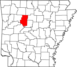
North Dardanelle's position in Arkansas.
Usa edcp location map.svg
Red pog.svg
North Dardanelle, Arkansas
North Dardanelle, Arkansas (the United States)
Coordinates: 35°13′46″N93°08′29″W / 35.22944°N 93.14139°W / 35.22944; -93.14139
Country Flag of the United States.svg  United States
State Flag of Arkansas.svg  Arkansas
County Pope
Elevation
110 m (361 ft)
Time zone UTC-6 (Central (CST))
  Summer (DST) UTC-5 (CDT)
GNIS feature ID77859

North Dardanelle is an unincorporated community in Illinois Township, Pope County, Arkansas, United States. [1]

Related Research Articles

<span class="mw-page-title-main">Yell County, Arkansas</span> County in Arkansas, United States

Yell County is a county in the U.S. state of Arkansas. As of the 2020 census, the population was 20,263. The county has two county seats, Dardanelle and Danville. Yell County is Arkansas's 42nd county, formed on December 5, 1840, from portions of Scott and Pope counties. It was named after Archibald Yell, who was the state's first member of the United States House of Representatives and the second governor of Arkansas. He died in combat at the Battle of Buena Vista during the Mexican–American War.

<span class="mw-page-title-main">Russellville, Arkansas</span> City in Arkansas, United States

Russellville is the county seat and largest city in Pope County, Arkansas, United States, with a 2021 estimated population of 29,338. It is home to Arkansas Tech University. Arkansas Nuclear One, Arkansas' only nuclear power plant is nearby. Russellville borders Lake Dardanelle and the Arkansas River.

<span class="mw-page-title-main">Dardanelle, Arkansas</span> City in Arkansas, United States

Dardanelle is a city in northeast Yell County, Arkansas, United States. The population was 4,745 at the 2010 census. Along with Danville, it serves as a county seat for Yell County. It is located near Lake Dardanelle.

<span class="mw-page-title-main">Arkansas Highway 7</span> Highway in Arkansas

Highway 7 is a north–south state highway that runs across the state of Arkansas. As Arkansas's longest state highway, the route runs 297.27 miles (478.41 km) from Louisiana Highway 558 at the Louisiana state line north to Bull Shoals Lake at Diamond City near the Missouri state line. With the exception of the segment north of Harrison, Highway 7 has been designated as an Arkansas Scenic Byway and a National Forest Scenic Byway. The road passes through the heart of both the Ozark Mountains and the Ouachita Mountains, and features scenic views. It's the route favored by motorcycle riders touring the region.

<span class="mw-page-title-main">Dardanelle and Russellville Railroad</span>

The Dardanelle and Russellville Railroad Company (D&R) is a Class III short-line railroad headquartered in Russellville, Arkansas.

<span class="mw-page-title-main">Arkansas Highway 27</span>

Arkansas Highway 27 is a designation for two north–south state highways in Arkansas. One route begins at US Highway 59 (US 59) and US 71 near Ben Lomond north to Highway 7 in Dardanelle. A second segment begins at Highway 7 in Dover and runs north to Highway 14 at Harriet. An original Arkansas state highway, Highway 27 was created as one continuous route in 1926, but was split around Russellville in 1961.

<span class="mw-page-title-main">Arkansas Highway 22</span>

Highway 22 is an east–west state highway in the Arkansas River Valley. It is maintained by the Arkansas State Highway and Transportation Department (AHTD). The highway runs 75.60 miles (121.67 km) from US 64/US 71B east to Highway 7 in Dardanelle. Following the historic stagecoach line of the cross-country Butterfield Trail, the highway is one of the original 1926 state highways. It is designated by the AHTD as the True Grit Trail.

<span class="mw-page-title-main">Lake Dardanelle</span> Reservoir in Arkansas

Lake Dardanelle is a major reservoir on the Arkansas River in Arkansas, USA. and is an integral part of the McClellan-Kerr Arkansas River Navigation System (MKARNS), which allows barge transportation from the Mississippi River to the Tulsa Port of Catoosa in northeastern Oklahoma. MKARNS went into service along its full length in 1971.

<span class="mw-page-title-main">Mount Nebo (Arkansas)</span>

Located near Dardanelle, Arkansas and rising about 1,350 feet (410 m) above the mountain valleys of west-central Arkansas to an elevation of about 1,755 feet (535 m) above sea level, Mount Nebo has views of 34,000 acres (140 km2) Lake Dardanelle, the Arkansas River and the surrounding mountain ridges. Atop this biblically named plateau is Mount Nebo State Park. Developed as a resort area in the late 19th century, it became a state park in 1928, its early development spearheaded by the Civilian Conservation Corps. Park activities include hiking, camping, and other outdoor pursuits.

<span class="mw-page-title-main">Henderson M. Jacoway</span> American politician

Henderson Madison Jacoway was an American lawyer and politician who served six terms as a U.S. Representative from Arkansas from 1911 to 1923.

<span class="mw-page-title-main">Thomas Boles</span> American politician

Thomas Boles was an American politician, a judge, and a U.S. Representative from Arkansas.

<span class="mw-page-title-main">Arkansas Highway 28</span>

Highway 28 is designation for three east–west state highways in Western Arkansas. Two segments together running from the Oklahoma state line to Ola have been established since the original 1926 Arkansas state highway numbering, with the third segment designated in 1963. All three highways are rural, two-lane roads with relatively low traffic serving a sparsely populated and forested part of Arkansas. The highways are maintained by the Arkansas Department of Transportation (ARDOT).

<span class="mw-page-title-main">New Blaine, Arkansas</span> Census-designated place in Arkansas, United States

New Blaine is an unincorporated community and census-designated place (CDP) in Logan County, Arkansas, United States. Per the 2020 census, the population was 173.

<span class="mw-page-title-main">Arkansas Highway 326</span>

Highway 326 is a designation for two state highways in Pope County. One route of 9.96 miles (16.03 km) in Russellville begins at Highway 7 and Highway 7 Truck and runs northeast to Highway 7. A second route of 6.52 miles (10.49 km) begins at Highway 124 and runs east to Highway 105. All routes are maintained by the Arkansas State Highway and Transportation Department (AHTD).

Illinois Township is one of nineteen current townships in Pope County, Arkansas, USA. As of the 2010 census, its total population was 29,813, with 91.8 percent contained in urban Russellville.

<span class="mw-page-title-main">Norristown, Arkansas</span> Place in Arkansas, United States

Norristown was a 19th-century town and trading center on the Arkansas River and, later, an incorporated town on Norristown Mountain in Illinois Township, Pope County, Arkansas, United States. The town merged with Russellville on August 14, 1980.

<span class="mw-page-title-main">Arkansas Highway 155</span>

Arkansas Highway 155 is a designation for four state highways in Arkansas. The northernmost segment of 7.10 miles (11.43 km) runs from Mount Nebo State Park to AR 22 in Dardanelle. A second segment in Yell County of 7.56 miles (12.17 km) connects Highway 7 and Highway 154. A third segment runs 11.16 miles (17.96 km) from AR 10 near Casa to Petit Jean State Park. The fourth segment is a 2.68-mile (4.31 km) spur from Highway 60 south to an area near Deberrie.

Dardanelle High School is a comprehensive public secondary school located in Dardanelle, Arkansas, United States, for students in grades nine through twelve. Dardanelle is the sole high school administered by the Dardanelle School District and serves three counties in the Arkansas River Valley area and as the main feeder school for Dardanelle Middle School. The school is known as the only high school with the Sand Lizard as its school mascot.

<span class="mw-page-title-main">Dardanelle Agriculture and Post Office</span> United States historic place

The Dardanelle Post Office, originally the Dardanelle Agriculture and Post Office, is a historic government building at 103 North Front Street in downtown Dardanelle, Arkansas. It is a single-story brick building, with a hip roof. It has a five-bay front facade, with a center entrance flanked by pilasters and topped by a panel, transom window, and dentillated entablature. Built in 1937, it has modest Colonial Revival style, and is most notable for the mural in the lobby, painted in 1939 by Ludwig Mactarian, and entitled Cotton Growing, Manufacture and Export.

References

  1. "Feature Detail Report for: North Dardanelle, Arkansas." USGS. Profile. Retrieved June 23, 2010.