Economy, Arkansas

Last updated

Economy, Arkansas
USA Arkansas location map.svg
Red pog.svg
Economy, Arkansas
Center Valley's position in Arkansas.
Usa edcp location map.svg
Red pog.svg
Economy, Arkansas
Economy, Arkansas (the United States)
Coordinates: 35°18′00″N92°53′35″W / 35.30000°N 92.89306°W / 35.30000; -92.89306
Country Flag of the United States (23px).png  United States
State Flag of Arkansas.svg  Arkansas
County Pope
Elevation
102 m (335 ft)
Time zone UTC-6 (Central (CST))
  Summer (DST) UTC-5 (CDT)
GNIS feature ID57698

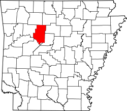
Economy is an unincorporated community in Burnett Township, Pope County, Arkansas, United States. [1]

As of 2024 Mark Coffman is serving as Constable. [2]

Related Research Articles

<span class="mw-page-title-main">Pope County, Arkansas</span> County in Arkansas, United States

Pope County is a county in the U.S. state of Arkansas. As of the 2020 census, the population was 63,381. The county seat is Russellville. The county was formed on November 2, 1829, from a portion of Crawford County and named for John Pope, the third governor of the Arkansas Territory. Pope County was the nineteenth county formed. The county's borders changed eighteen times in the 19th century with the creation of new counties and adjustments between counties. The current boundaries were set on March 8, 1877.

<span class="mw-page-title-main">Dover, Arkansas</span> City in Arkansas, United States

Dover is a town in Pope County, Arkansas, United States. The population was 1,378 at the 2010 census. Dover is located in the Arkansas River Valley, and is part of the Russellville Micropolitan Statistical Area.

<span class="mw-page-title-main">Russellville, Arkansas</span> City in Arkansas, United States

Russellville is the county seat and largest city in Pope County, Arkansas, United States, with a 2022 estimated population of 29,133. It is home to Arkansas Tech University. Arkansas Nuclear One, Arkansas' only nuclear power plant is nearby. Russellville borders Lake Dardanelle and the Arkansas River.

<span class="mw-page-title-main">John Pope (Kentucky politician)</span> American politician (1770–1845)

John Pope was a United States Senator from Kentucky. He was a member of the United States House of Representatives from Kentucky, Secretary of State of Kentucky, and the third Governor of Arkansas Territory.

<span class="mw-page-title-main">Arkansas Tech University</span> Public university in Russellville, Arkansas, US

Arkansas Tech University (ATU) is a public university in Russellville, Arkansas, United States. The university offers programs at both baccalaureate and graduate levels in a range of fields. The Arkansas Tech University–Ozark Campus, a two-year satellite campus in the town of Ozark, primarily focuses on associate and certificate education.

<span class="mw-page-title-main">Index of Arkansas-related articles</span>

The following is an alphabetical list of articles related to the U.S. State of Arkansas.

<span class="mw-page-title-main">Arkansas Highway 333</span> Highway in Arkansas

Highway 333 is a designation of three north–south state highways in Arkansas. One route begins at US Highway 64 (US 64) and runs north 17.20 miles (27.68 km) to Highway 7. A second highway begins at Searcy County Road 8 (CR 8) and runs north to US 65 near Marshall. A third segment connects Gilbert to the state highway system. All three highways were created and modified to their existing alignments between 1965 and 1974, and are maintained by the Arkansas Department of Transportation (ArDOT).

<span class="mw-page-title-main">Arkansas Highway 164</span> Highway in Arkansas

Highway 164 is a designation for four segments of state highway in the Arkansas River Valley. Each are low-volume local roads providing connectivity to small communities, or recreation areas near the Ozark National Forest. The first segment was created in 1945, with the remaining segments created during the late 1950s and 1960s, a period of major Arkansas Highway System expansion. A single spur route provides access to an industrial area in Clarksville. All routes are maintained by the Arkansas Department of Transportation (ArDOT).

<span class="mw-page-title-main">Arkansas Highway 105</span> State highway in Arkansas, United States

Highway 105 is a north–south state highway in Pope County, Arkansas. The route runs from Galla Creek Wildlife Management Area north across Interstate 40 (I-40) and U.S. Route 64 (US 64) to Highway 27 in Hector. AR 105 was created during the 1926 Arkansas state highway numbering. The route is maintained by the Arkansas Department of Transportation (ArDOT).

<span class="mw-page-title-main">Arkansas Highway 247</span> Highway in Arkansas

Highway 247 is a designation for four north–south state highways in the Arkansas River Valley. Two are low traffic, two-lane, rural connector highways serving sparsely populated areas of the River Valley. A third segment is a four-lane highway bypassing Pottsville. A fourth segment mostly runs as Poor Farm Road in Morrilton among several educational buildings in the city. The first rural segment was created in 1957, with the Morrilton segment created in 1965 and a second rural segment in 1966. The final designation came in 1973. All segments are maintained by the Arkansas Department of Transportation (ArDOT).

Lost Corner is an unincorporated community in Pope County, Arkansas, United States. The community changed its name from Okay to avoid confusion with a community in Howard County with the same name. Lost Corner was selected because of the backwoods location of the community.

<span class="mw-page-title-main">Norristown, Arkansas</span> Place in Arkansas, United States

Norristown was a 19th-century town and trading center on the Arkansas River and, later, an incorporated town on Norristown Mountain in Illinois Township, Pope County, Arkansas, United States. The town merged with Russellville on August 14, 1980.

Oak Grove is an unincorporated community and census-designated place (CDP) in Moreland Township, Pope County, Arkansas, United States. It was first listed as a CDP in the 2020 census with a population of 177.

Retta is an unincorporated community in Jackson Township, Pope County, Arkansas, United States. It is a populated place located within the Township of Jackson, a minor civil division (MCD) of Pope County. The elevation of Retta is 679 feet. Retta appears on the Solo U.S. Geological Survey Map. Pope County is in the Central Time Zone. The local timezone is named " America/Chicago''.

Shiloh is a populated area that lies partly in Russellville and partly in unincorporated Pope County, Arkansas, United States. It is located between Interstate 40 and Dover on Arkansas Highway 7.

<span class="mw-page-title-main">1996 United States presidential election in Arkansas</span>

The 1996 United States presidential election in Arkansas took place on November 5, 1996, as part of the 1996 United States presidential election. State voters chose six electors to the Electoral College, who voted for president and vice president.

<span class="mw-page-title-main">Arkansas River Valley</span> Region in Arkansas, United States

The Arkansas River Valley, also known as the Arkansas Valley, is a region in Arkansas defined by the Arkansas River in the western part of the state. Generally defined as the area between the Ozark and Ouachita Mountains, the River Valley is characterized by flat lowlands covered in fertile farmland and lakes periodically interrupted by high peaks. Mount Magazine, Mount Nebo, and Petit Jean Mountain compose the Tri-Peaks Region, a further subdivision of the River Valley popular with hikers and outdoors enthusiasts. In addition to the outdoor recreational activities available to residents and visitors of the region, the River Valley contains Arkansas's wine country as well as hundreds of historical sites throughout the area. It is one of six natural divisions of Arkansas.

<span class="mw-page-title-main">2016 United States Senate election in Arkansas</span>

The 2016 United States Senate election in Arkansas was held November 8, 2016, to elect a member of the United States Senate to represent the State of Arkansas, concurrently with the 2016 U.S. presidential election, as well as other elections to the United States Senate in other states and elections to the United States House of Representatives and various state and local elections.

<span class="mw-page-title-main">County government in Arkansas</span> Subdivisions of Arkansas

County government in Arkansas is a political subdivision of the state established for a more convenient administration of justice and for purposes of providing services for the state by the Constitution of Arkansas and the Arkansas General Assembly through the Arkansas Code. In Arkansas, counties have no inherent authority, only power given to them by the state government. This means the county executive, the county judge, and legislative body, the quorum court, have limited power compared to other states.

References

  1. "Feature Detail Report for: Economy, Arkansas." USGS. Profile. Retrieved June 23, 2010.
  2. "Pope County Constables". Pope County. Retrieved January 2, 2025.