Pope County is a county in the U.S. state of Arkansas. As of the 2020 census, the population was 63,381. The county seat is Russellville. The county was formed on November 2, 1829, from a portion of Crawford County and named for John Pope, the third governor of the Arkansas Territory. Pope County was the nineteenth county formed. The county's borders changed eighteen times in the 19th century with the creation of new counties and adjustments between counties. The current boundaries were set on March 8, 1877.

Johnson County is a county located in the U.S. state of Arkansas. As of the 2020 census, the population was 25,749. The county seat is Clarksville. Johnson County is Arkansas's 30th county, formed on November 16, 1833, from a portion of Pope County and named for Benjamin Johnson, a Territorial Judge. It is an alcohol prohibition or dry county.

Dover is a town in Pope County, Arkansas, United States. The population was 1,378 at the 2010 census. Dover is located in the Arkansas River Valley, and is part of the Russellville Micropolitan Statistical Area.

Russellville is the county seat and largest city in Pope County, Arkansas, United States, with a 2022 estimated population of 29,133. It is home to Arkansas Tech University. Arkansas Nuclear One, Arkansas' only nuclear power plant is nearby. Russellville borders Lake Dardanelle and the Arkansas River.

OzraAmander Hadley was an American politician who served as the acting governor of Arkansas from 1871 to 1873.

John Pope was a United States Senator from Kentucky. He was a member of the United States House of Representatives from Kentucky, Secretary of State of Kentucky, and the third Governor of Arkansas Territory.
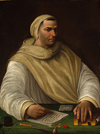
The Olivetans, formally known as the Order of Our Lady of Mount Olivet, are a monastic order. They were founded in 1313 and recognised in 1344. They use the Rule of Saint Benedict and are a member of the Benedictine Confederation, where they are also known as the Olivetan Congregation, but are distinguished from the Benedictines in their white habit and centralized organisation. They use the post-nominals 'OSB Oliv'.

Arkansas Tech University (ATU) is a public university in Russellville, Arkansas, United States. The university offers programs at both baccalaureate and graduate levels in a range of fields. The Arkansas Tech University–Ozark Campus, a two-year satellite campus in the town of Ozark, primarily focuses on associate and certificate education.

Lake Dardanelle is a major reservoir on the Arkansas River in Arkansas, USA. and is an integral part of the McClellan-Kerr Arkansas River Navigation System (MKARNS), which allows barge transportation from the Mississippi River to the Tulsa Port of Catoosa in northeastern Oklahoma. MKARNS went into service along its full length in 1971.

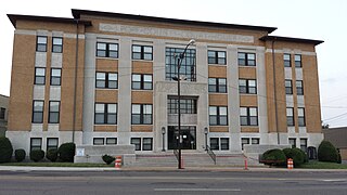
This is a list of the National Register of Historic Places listings in Pope County, Arkansas.
Griffin Township is one of nineteen current townships in Pope County, Arkansas, USA. As of the 2010 census, its total population was 839.
Galla Rock is an unincorporated community in Wilson Township, southern Pope County, Arkansas, United States. The community is on Arkansas Route 105 just north of the Arkansas River and the Pope-Yell county line. Atkins is approximately 4.5 miles to the north along Route 105.
Georgetown is an unincorporated community in Clark Township, Pope County, Arkansas, United States.
Lost Corner is an unincorporated community in Pope County, Arkansas, United States. The community changed its name from Okay to avoid confusion with a community in Howard County with the same name. Lost Corner was selected because of the backwoods location of the community.

Norristown was a 19th-century town and trading center on the Arkansas River and, later, an incorporated town on Norristown Mountain in Illinois Township, Pope County, Arkansas, United States. The town merged with Russellville on August 14, 1980.
Oak Grove is an unincorporated community and census-designated place (CDP) in Moreland Township, Pope County, Arkansas, United States. It was first listed as a CDP in the 2020 census with a population of 177.
Retta is an unincorporated community in Jackson Township, Pope County, Arkansas, United States. It is a populated place located within the Township of Jackson, a minor civil division (MCD) of Pope County. The elevation of Retta is 679 feet. Retta appears on the Solo U.S. Geological Survey Map. Pope County is in the Central Time Zone. The local timezone is named " America/Chicago''.
Shiloh is a populated area that lies partly in Russellville and partly in unincorporated Pope County, Arkansas, United States. It is located between Interstate 40 and Dover on Arkansas Highway 7.

The 1996 United States presidential election in Arkansas took place on November 5, 1996, as part of the 1996 United States presidential election. State voters chose six electors to the Electoral College, who voted for president and vice president.
Wilson is an unincorporated community in Wilson Township of southern Pope County, Arkansas, United States. The community is on Arkansas Route 105 approximately two miles south of Atkins.


