Wilson, Pope County, Arkansas

Last updated
Wilson, Arkansas
USA Arkansas location map.svg
Red pog.svg
Wilson, Arkansas
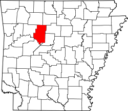
Wilson's position in Arkansas.
Usa edcp location map.svg
Red pog.svg
Wilson, Arkansas
Wilson, Arkansas (the United States)
Coordinates: 35°12′37″N92°55′47″W / 35.21028°N 92.92972°W / 35.21028; -92.92972 Coordinates: 35°12′37″N92°55′47″W / 35.21028°N 92.92972°W / 35.21028; -92.92972
Country Flag of the United States.svg  United States
State Flag of Arkansas.svg  Arkansas
County Pope
Township Wilson
Elevation
[1]
96 m (315 ft)
Time zone UTC-6 (Central (CST))
  Summer (DST) UTC-5 (CDT)
GNIS feature ID58898 [1]

Wilson is an unincorporated community in Wilson Township of southern Pope County, Arkansas, United States. [1] The community is on Arkansas Route 105 approximately two miles south of Atkins. [2]


Related Research Articles

<span class="mw-page-title-main">Pope County, Arkansas</span> County in Arkansas, United States

Pope County is a county in the U.S. state of Arkansas. As of the 2020 census, the population was 63,381. The county seat is Russellville. The county was formed on November 2, 1829, from a portion of Crawford County and named for John Pope, the third governor of the Arkansas Territory. Pope County was the nineteenth county formed. The county's borders changed eighteen times in the 19th century with the creation of new counties and adjustments between counties. The current boundaries were set on 8 March 1877.

<span class="mw-page-title-main">Russellville, Arkansas</span> City in Arkansas, United States

Russellville is the county seat and largest city in Pope County, Arkansas, United States, with a 2021 estimated population of 29,338. It is home to Arkansas Tech University. Arkansas Nuclear One, Arkansas' only nuclear power plant is nearby. Russellville borders Lake Dardanelle and the Arkansas River.

Wilson Township may refer to the following places in the United States:

<span class="mw-page-title-main">Arkansas Tech University</span> Public university in Russellville, Arkansas

Arkansas Tech University (ATU) is a public university in Russellville, Arkansas. The university offers programs at both baccalaureate and graduate levels in a range of fields. The Arkansas Tech University–Ozark Campus, a two-year satellite campus in the town of Ozark, primarily focuses on associate and certificate education.

<span class="mw-page-title-main">United States District Court for the Eastern District of Arkansas</span> U.S. federal district court in Arkansas

The United States District Court for the Eastern District of Arkansas is a federal court in the Eighth Circuit.

Bethel is an unincorporated community in Illinois Township, Pope County, Arkansas, United States.

Bullfrog Valley is an unincorporated community in Illinois Township, Pope County, Arkansas, United States. It is located on Arkansas Highway 164 near the Johnson County line. The community is also located north of Silex.

Wilson Township is one of nineteen current townships in Pope County, Arkansas, USA. As of the 2010 census, its unincorporated population was 4,774. It now contains the former township of Lee.

Galla Rock is an unincorporated community in Wilson Township, southern Pope County, Arkansas, United States. The community is on Arkansas Route 105 just north of the Arkansas River and the Pope-Yell county line. Atkins is approximately 4.5 miles to the north along Route 105.

Georgetown is an unincorporated community in Clark Township, Pope County, Arkansas, United States.

Happy Bend is an unincorporated community in Wilson Township, Pope County, Arkansas, United States.

Lost Corner is an unincorporated community in Pope County, Arkansas, United States. The community changed its name from Okay to avoid confusion with a community in Howard County with the same name. Lost Corner was selected because of the backwoods location of the community.

Oak Grove is an unincorporated community and census-designated place (CDP) in Moreland Township, Pope County, Arkansas, United States. It was first listed as a CDP in the 2020 census with a population of 177.

Retta is an unincorporated community in Jackson Township, Pope County, Arkansas, United States. It is a populated place located within the Township of Jackson, a minor civil division (MCD) of Pope County. The elevation of Retta is 679 feet. Retta appears on the Solo U.S. Geological Survey Map. Pope County is in the Central Time Zone. The local timezone is named " America/Chicago''.

Shiloh is a populated area that lies partly in Russellville and partly in unincorporated Pope County, Arkansas, United States. It is located between Interstate 40 and Dover on Arkansas Highway 7.

Treat is an unincorporated community in Pope County, Arkansas, United States.

Walnut Grove was an unincorporated community in Jackson Township, Pope County, Arkansas, United States. It was located on Walnut Grove Road, east of Hector. The Walnut Grove cemetery and church are approximately one mile apart at the location indicated with the cemetery adjacent to Dare Creek and the church on a hilltop one mile to the south.

Welcome is an unincorporated community in Griffin Township of eastern Pope County, Arkansas, United States. It is located at the intersection of Welcome Home Road and Pine Street, southeast of Hector and northwest of Appleton.

Gold Hill is an unincorporated community in Wilson Township, Pope County, Arkansas, United States.

Atkins High School is a comprehensive public high school located in the rural, distant community of Atkins, Arkansas, United States. The school provides secondary education for students in grades 9 through 12. It is one of nine public high schools in Pope County, Arkansas and the sole high school administered by the Atkins School District on the district's 60 acres (24 ha) campus.

References

  1. 1 2 3 U.S. Geological Survey Geographic Names Information System: Wilson, Pope County, Arkansas
  2. Arkansas Atlas & Gazetteer, DeLorme, 2004, 2nd edition, p. 40, ISBN   0-89933-345-1