Pleasant Valley, Pope County, Arkansas

Last updated
Pleasant Valley, Arkansas
USA Arkansas location map.svg
Red pog.svg
Pleasant Valley, Arkansas
Position in Arkansas
Coordinates: 35°26′N93°08′W / 35.433°N 93.133°W / 35.433; -93.133 Coordinates: 35°26′N93°08′W / 35.433°N 93.133°W / 35.433; -93.133
Country Flag of the United States.svg  United States
State Flag of Arkansas.svg  Arkansas
County Pope
Elevation
160 m (525 ft)
Time zone UTC-6 (Central (CST))
  Summer (DST) UTC-5 (CDT)
GNIS feature ID73136

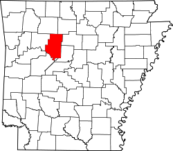
Pleasant Valley is an unincorporated community in Dover Township, Pope County, Arkansas, United States. [1]

Related Research Articles

Yell County, Arkansas U.S. county in Arkansas

Yell County is a county in the U.S. state of Arkansas. As of the 2010 census, the population was 22,185. The county has two county seats, Dardanelle and Danville. Yell County is Arkansas's 42nd county, formed on December 5, 1840 from portions of Scott and Pope counties. It was named after Archibald Yell, who was the state's first member of the United States House of Representatives and the second governor of Arkansas; he later was killed in combat at the Battle of Buena Vista during the Mexican–American War. It is an alcohol prohibition or dry county.

Stone County, Arkansas U.S. county in Arkansas

Stone County is located in the Ozark Mountains in the U.S. state of Arkansas. The county is named for rugged, rocky area terrain of the Ozarks. Created as Arkansas's 74th county on April 21, 1873, Stone County has two incorporated cities: Mountain View, the county seat and most populous city, and Fifty-Six. The county is also the site of numerous unincorporated communities and ghost towns.

Izard County, Arkansas U.S. county in Arkansas

Izard County is a county located in the U.S. state of Arkansas. As of the 2010 census, the population was 13,696. The county seat is Melbourne. Izard County is Arkansas's thirteenth county, formed on October 27, 1825, and named for War of 1812 General and Arkansas Territorial Governor George Izard. It is an alcohol prohibition or dry county.

Pleasant Valley may refer to:

St. Louis Southwestern Railway Defunct American railway

The St. Louis Southwestern Railway Company, known by its nickname of "The Cotton Belt Route" or simply "Cotton Belt", is a former US Class I railroad which operated between St. Louis, Missouri, and various points in the states of Arkansas, Tennessee, Louisiana, and Texas from 1891 to 1980. In 1980 the Cotton Belt began operating the Rock Island's Golden State Route which added the states of Kansas, Oklahoma, and New Mexico to the operation. Operation of the Cotton Belt was assumed by parent Southern Pacific Transportation Company in 1992.

Pinnacle Valley is the northwesternmost neighborhood of the city of Little Rock, Arkansas. The area is to the south of Pinnacle Mountain, one of the highest elevations in Pulaski County. Like Chenal Valley which borders the area on its south side, Pinnacle Valley is a fast-developing portion of Little Rock as the city continues to expand westward.

National Register of Historic Places listings in Arkansas Wikimedia list article

This is a list of properties and historic districts in Arkansas that are listed on the National Register of Historic Places. There are more than 2,600 listings in the state, including at least 8 listings in each of Arkansas's 75 counties.

Pleasant Valley is a neighborhood that is among the older western neighborhoods of the city of Little Rock, Arkansas. The area is to the northwest of Breckenridge and west of Colony West. Pleasant Valley lies to the south of the hillier Pleasant Ridge and Walton Heights areas, and mostly to the east of St. Charles.

The New England Classic was a golf tournament on the PGA Tour from 1969 through 1998. It was held under various names at Pleasant Valley Country Club in Sutton, Massachusetts.

Arkansas Highway 143 highway in Arkansas

Highway 143 is a north–south state highway in Carroll County, Arkansas. The highway begins at US Highway 62 (US 62) and Highway 980 near Pleasant Valley and runs northwest to Missouri supplemental route H at the Missouri state line. The route is maintained by the Arkansas Department of Transportation (ArDOT).

Pleasant Valley No. 288 is a rural municipality in the Canadian province of Saskatchewan. The municipality is located in the Census Division 12 which is a part of SARM Division 6. The seat of the municipality is located in the Town of Rosetown.

Pleasant Valley, Carroll County, Arkansas Unincorporated community in Arkansas, United States

Pleasant Valley is an unincorporated community in Carroll County, Arkansas, United States. The community is located on Arkansas Highway 143.

Floral, Arkansas Unincorporated community in Arkansas, United States

Floral is an unincorporated community in Independence County, Arkansas, United States. Floral is located on Arkansas Highway 87, 8 miles (13 km) west-northwest of Pleasant Plains. Floral has a post office with ZIP code 72534.

Pleasant Hill, Scott County, Arkansas Unincorporated community in Arkansas, United States

Pleasant Hill is an unincorporated community in Scott County, Arkansas, United States. Pleasant Hill is located on Arkansas Highway 80, 1.9 miles (3.1 km) west of Waldron.

Sneed is a ghost town in Jackson County, Arkansas, United States. It was abandoned in 1929 following an F5 tornado.

Highway 238 is an east–west state highway in the Lower Arkansas Delta. The route of 17.57 miles (28.28 km) begins at US Highway 49/US Highway 70 in Brinkley and runs east to US 79 near Moro. The route is maintained by the Arkansas State Highway and Transportation Department (AHTD).

Mulberry School District was a school district headquartered in Mulberry, Arkansas.

Mount Pleasant School District (MPSD) was a school district headquartered in Mount Pleasant, Arkansas. It had a single school, the Mount Pleasant School.

Pleasant Valley is a residential neighborhood in Wichita, Kansas, United States. It lies on the west bank of the Little Arkansas River in the northwestern part of the city.

References

  1. "Feature Detail Report for: Pleasant Valley, Arkansas." USGS. Profile. Retrieved June 25, 2010.