Pope County is a county in the U.S. state of Arkansas. As of the 2020 census, the population was 63,381. The county seat is Russellville. The county was formed on November 2, 1829, from a portion of Crawford County and named for John Pope, the third governor of the Arkansas Territory. Pope County was the nineteenth county formed. The county's borders changed eighteen times in the 19th century with the creation of new counties and adjustments between counties. The current boundaries were set on March 8, 1877.

Dover is a town in Pope County, Arkansas, United States. The population was 1,378 at the 2010 census. Dover is located in the Arkansas River Valley, and is part of the Russellville Micropolitan Statistical Area.

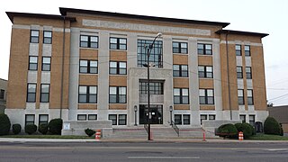
Russellville is the county seat and largest city in Pope County, Arkansas, United States, with a 2022 estimated population of 29,133. It is home to Arkansas Tech University. Arkansas Nuclear One, Arkansas' only nuclear power plant is nearby. Russellville borders Lake Dardanelle and the Arkansas River.

Dwight Presbyterian Mission was one of the first American missions to the Native Americans. It was established near present-day Russellville, Arkansas in 1820 to serve the Arkansas Cherokees. After the Cherokee were required to move to Indian Territory in 1828, the mission was reestablished in 1829 near present-day Marble City, Oklahoma. The mission is listed on the National Register of Historic Places.

Jeff Davis was an American Democratic politician who served as the 20th governor of Arkansas from 1901 to 1907 and in the U.S. Senate from 1907 to 1913. He took office as one of Arkansas's first New South governors and proved to be one of the state's most polarizing figures. Davis used his silver tongue and aptitude for demagoguery to exploit existing feelings of agrarian frustration among poor white farmers and thus built a large populist appeal. However, since Davis often blamed city-dwellers, blacks, and Yankees for problems on the farm, the state was quickly and ardently split into "pro-Davis" and "anti-Davis" factions.

OzraAmander Hadley was an American politician who served as the acting governor of Arkansas from 1871 to 1873. He also served in the Arkansas Senate. A Republican, he was from New York and became a farmer in Minnesota. He also served in local government before moving to Arkansas and opening a general store. After his political career he served in the U.S. Land Office in Little Rock and as a postmaster.
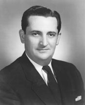
Thomas Dale Alford Sr. was an American ophthalmologist and politician from the U.S. state of Arkansas who served as a conservative Democrat in the United States House of Representatives from Little Rock from 1959 to 1963.
Ronald Gene Simmons Sr. was an American mass murderer who killed 16 people over a week-long period in Arkansas in 1987 and wounded several others. A retired military serviceman, Simmons murdered fourteen members of his family, including a daughter he had sexually abused and the child he had fathered with her, as well as a former co-worker, and a stranger; he also wounded four others. He is the most prolific mass murderer in Arkansas history. His shooting is also the deadliest mass shooting in Arkansas history.
The Mason County War, sometimes called the Hoodoo War in reference to masked members of a vigilance committee, was a period of lawlessness ignited by a "tidal wave of rustling" in Mason County, Texas in 1875 and 1876. The violence entailed a series of mob lynchings and retaliatory murders involving multiple posses and law enforcement factions, including the Texas Rangers. The conflict took the lives of at least 12 men and resulted in a climate of bitter "national prejudice" against local German-American residents in the following years.

Norristown was a 19th-century town and trading center on the Arkansas River and, later, an incorporated town on Norristown Mountain in Illinois Township, Pope County, Arkansas, United States. The town merged with Russellville on August 14, 1980.

The Arkansas River Valley, also known as the Arkansas Valley, is a region in Arkansas defined by the Arkansas River in the western part of the state. Generally defined as the area between the Ozark and Ouachita Mountains, the River Valley is characterized by flat lowlands covered in fertile farmland and lakes periodically interrupted by high peaks. Mount Magazine, Mount Nebo, and Petit Jean Mountain compose the Tri-Peaks Region, a further subdivision of the River Valley popular with hikers and outdoors enthusiasts. In addition to the outdoor recreational activities available to residents and visitors of the region, the River Valley contains Arkansas's wine country as well as hundreds of historical sites throughout the area. It is one of six natural divisions of Arkansas.

The Arkansas Militia in Reconstruction was deeply involved in the ongoing civil disturbances which plagued the state until the late 1870s. In the immediate aftermath of the Civil War, the militia was first utilized by the white population to re-establish control over the newly freed black population. Radical Republicans seized control in 1867 and abolished existing state governments and militia organizations, and disenfranchised former Confederates. The new disenfranchised whites turned to the shadow Ku Klux Klan to attempt to maintain social order. The Reconstructionist government raised a new militia, primarily of black soldiers with white officers and utilized this new "Black militia" to put down the rising power of the Ku Klux Klan. Armed conflicts between rival parties continued in several counties and the militia was called to re-establish control in Pope and Scott Counties. The most severe conflict of this period occurred during the so-called Brooks–Baxter War with rival parties, with supporting militias, battling for control of the governorship. With the end of reconstruction one of the first acts of the new resurgent Democratic state legislature was to abolish the office of adjutant general in retaliation for the use of the militia to enforce the rule of the Reconstruction government.

The Battleground Gunfight, also known as the Battleground Shootout, was a gunfight between a posse of American lawmen and the Smith Gang. It was fought on October 8, 1901, within Arizona Territory's Fort Apache Indian Reservation, at a clearing in the forest known today as the "Battleground". Nine Arizona Rangers and deputies caught up with the cattle rustler Bill Smith and his gang. During a long exchange of gunfire that followed, Ranger Carlos Tafolla and Deputy Bill Maxwell were killed and one or two of the outlaws may have been wounded. In the end, the Smith Gang escaped the posse and fled into Mexico.
The 10th (Newton's) Arkansas Cavalry (1864–1865) was a Confederate Army Cavalry regiment during the American Civil War. The unit was originally organized from volunteer companies raised from the Arkansas State Militia in the Southern Arkansas Counties in the winter of 1863–1864 after the fall of Little Rock. It was originally organized as Pettus Battalion, Arkansas State Troops but was later enrolled in Confederal Service and Robert C. Newton was elected Colonel.
The 1st Battalion, Arkansas State Troops (1863–1864) was an Arkansas State Cavalry battalion during the American Civil War. The unit is also sometimes referred to as Pettus' Battalion or Trader's Battalion, Arkansas State Troops. The unit was eventually consolidated with other units in late 1864 to form the Newton's 10th Arkansas Cavalry Regiment.

The Power's Cabin shootout, or the Power Brothers shootout, occurred on February 10, 1918, when a posse attempted to arrest a group of miners at their cabin in the Galiuro Mountains. Four men were killed during the shootout, including three lawmen and Jeff Power, the owner of the cabin. The Power brothers, Tom and John, then escaped to Mexico with a man named Tom Sisson, but they were eventually caught after what was then the largest manhunt in the history of Arizona.
Thomas Cox was an American pioneer, politician, and surveyor from what is now Kentucky. His family moved to the Indiana Territory, where Cox joined the territory militia. He was promoted to a lieutenant colonel and may have seen service in the War of 1812. After the war, he became a surveyor to help support his family. He also served in county politics until the state of Illinois was formed in 1818. Cox was elected to its 1st General Assembly as a state senator, serving for two years. He then worked as Register of the U.S. Land Office in Springfield, Illinois, but fell into debt after some poor land speculation deals.
Jacob Lawson Shinn was a prosperous and influential mid to late-nineteenth-century leader in Russellville, Pope County, Arkansas. A successful merchant who established his first store in about 1852, Shinn was instrumental in bringing the Little Rock and Fort Smith Railroad (LR&FS) through town and moving the county seat from Dover to Russellville. At one time the wealthiest man and largest property owner in Pope County, he donated land for a railway station and right-of-way through Russellville for the LR&FS railroad as well as property for the new courthouse, the Russellville school system, and the church that he and his wife attended. After financial setbacks that reduced his wealth drastically, Shinn continued his service to the community until he died in office months after being elected mayor of Russellville.

In the aftermath of the American Civil War, Pope County, Arkansas experienced a tumultuous seven-month period during the Reconstruction era known as the Pope County Militia War. This time was characterized by political and civil unrest, as four county officials, aided by an unofficial militia, purportedly manipulated county affairs to benefit their own agenda. These officials persistently urged the Arkansas governor to impose martial law in the county, with the aim of exerting greater control over voter registration and the November 1872 election.

Joseph H. Battenfield was an American newspaper publisher and merchant based in Russellville, Arkansas, in the years after the American Civil War. His weekly newspaper regularly took local officials to task over what he saw as the plundering of county wealth and published details of unwarranted attempts by county officials to get martial law declared in Pope County. On September 8, 1872, during a period that came to be known as the Pope County Militia War, his newspaper office and press were burned, supposedly by the militia of Sheriff Elisha Dodson.

