Hector, Arkansas

Last updated

Hector, Arkansas
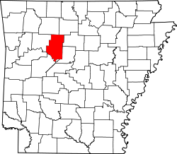
Pope County Arkansas Incorporated and Unincorporated areas Hector Highlighted 0531150.svg
Location of Hector in Pope County, Arkansas.
Coordinates: 35°27′53″N92°58′33″W / 35.46472°N 92.97583°W / 35.46472; -92.97583
Country United States
State Arkansas
County Pope
Area
[1]
  Total2.29 sq mi (5.93 km2)
  Land2.29 sq mi (5.92 km2)
  Water0.00 sq mi (0.01 km2)
Elevation
[2]
722 ft (220 m)
Population
 (2020)
  Total411
  Density179.79/sq mi (69.43/km2)
Time zone UTC-6 (Central (CST))
  Summer (DST) UTC-5 (CDT)
ZIP code
72843
Area code 479
FIPS code 05-31150
GNIS feature ID2405813 [2]
Website www.hectorar.com

Hector is a town in Pope County, Arkansas, United States. The population was 450 at the 2010 census. It is part of the Russellville Micropolitan Statistical Area.

Contents

Geography

According to the United States Census Bureau, the town has a total area of 6.0 km2 (2.3 sq mi), of which 6.0 km2 (2.3 sq mi) is land and 0.43% is water.

History

The community was named for President Grover Cleveland's dog by the President himself when postal officials grew frustrated with the residents' indecision on whether to name the community Avondale or The Plain. [3]

Demographics

Historical population
CensusPop.Note
1970 387
1980 44916.0%
1990 4786.5%
2000 5065.9%
2010 450−11.1%
2020 411−8.7%
U.S. Decennial Census [4]

At the 2000 census there were 506 people in 190 households, including 143 families, in the town. The population density was 84.6/km2 (219.5/mi2). There were 219 housing units at an average density of 36.6/km2 (95.0/mi2). The racial makeup of the town was 96.64% White, 0.99% Native American, 0.20% Asian, 0.20% Pacific Islander, 0.59% from other races, and 1.38% from two or more races. 2.57% of the population were Hispanic or Latino of any race. [5] Of the 190 households 39.5% had children under the age of 18 living with them, 57.9% were married couples living together, 14.7% had a female householder with no husband present, and 24.7% were non-families. 22.6% of households were one person and 14.2% were one person aged 65 or older. The average household size was 2.66 and the average family size was 3.16.

The age distribution was 30.4% under the age of 18, 7.5% from 18 to 24, 28.5% from 25 to 44, 19.8% from 45 to 64, and 13.8% 65 or older. The median age was 36 years. For every 100 females, there were 108.2 males. For every 100 females age 18 and over, there were 93.4 males.

The median household income was $31,250 and the median family income was $36,375. Males had a median income of $29,063 versus $18,750 for females. The per capita income for the town was $13,432. About 9.1% of families and 11.5% of the population were below the poverty line, including 15.7% of those under age 18 and 10.3% of those age 65 or over.

Education

Public education of elementary and secondary school students is provided by the Hector School District, including:

Climate

The climate in this area is characterized by hot, humid summers and generally mild to cool winters. According to the Köppen Climate Classification system, Hector has a humid subtropical climate, abbreviated "Cfa" on climate maps. [6]

Related Research Articles

<span class="mw-page-title-main">Almyra, Arkansas</span> Town in Arkansas, United States

Almyra is a town in Arkansas County, Arkansas, United States. The population was 283 at the 2010 census.

<span class="mw-page-title-main">Alpena, Arkansas</span> Town in Arkansas, United States

Alpena is a town in Boone and Carroll counties in the U.S. state of Arkansas. The population was 374 at the 2020 census.

<span class="mw-page-title-main">McDougal, Arkansas</span> City in Arkansas, United States

McDougal is a city in Clay County, Arkansas, United States. The population was 186 at the 2010 census.

<span class="mw-page-title-main">Beedeville, Arkansas</span> Town in Arkansas, United States

Beedeville is a town in Jackson County, Arkansas, United States. The population was 107 at the 2010 census.

<span class="mw-page-title-main">Alicia, Arkansas</span> Town in Arkansas, United States

Alicia is a town in Lawrence County, Arkansas, United States. The population was 124 at the 2010 census.

<span class="mw-page-title-main">College City, Arkansas</span> Former town in Arkansas, United States

College City is a former town in Lawrence County, Arkansas, United States. The population was 455 at the 2010 census. It is the site of Williams Baptist College, a four-year liberal arts college. The town merged with nearby Walnut Ridge effective January 1, 2017.

<span class="mw-page-title-main">Caulksville, Arkansas</span> Town in Arkansas, United States

Caulksville is a town in Logan County, Arkansas, United States. The population was 213 at the 2010 census.

<span class="mw-page-title-main">Roe, Arkansas</span> Town in Arkansas, United States

Roe is a town in Monroe County, Arkansas, United States. Located at the junction of U.S. Route 79 and Arkansas Highway 33, the population was 68 at the 2020 census, down from 114 in 2010.

<span class="mw-page-title-main">Rosston, Arkansas</span> Town in Arkansas, United States

Rosston is a town in south-central Nevada County, Arkansas, United States. The population was 265 at the 2000 census. It is part of the Hope Micropolitan Statistical Area.

<span class="mw-page-title-main">Perry, Arkansas</span> Town in Arkansas, United States

Perry is a town in Perry County, Arkansas, United States. The population was 314 at the 2000 census. It is part of the Little Rock–North Little Rock–Conway Metropolitan Statistical Area.

<span class="mw-page-title-main">Hatfield, Arkansas</span> Town in Arkansas, United States

Hatfield is a town in western Polk County, Arkansas, United States. The population was 413 at the 2010 census.

<span class="mw-page-title-main">Ulm, Arkansas</span> Town in Arkansas, United States

Ulm is a town in Prairie County, Arkansas, United States. The population was 205 at the 2000 census.

<span class="mw-page-title-main">Gilbert, Arkansas</span> Town in Arkansas, United States

Gilbert is a town in Searcy County, Arkansas, United States. The population was 26 at the 2020 census, ranking it as the smallest municipality in the state and one of the smallest in the nation. Over the years, Gilbert has gained a reputation as one of the coldest locations in Arkansas.

<span class="mw-page-title-main">Caldwell, Arkansas</span> Town in Arkansas, United States

Caldwell is a town in St. Francis County, Arkansas, United States. The population was 555 at the 2010 census, an increase from 465 in 2000.

<span class="mw-page-title-main">Widener, Arkansas</span> Town in Arkansas, United States

Widener is a town in St. Francis County, Arkansas, United States. The population was 212 at the 2020 census, a decline from 273 in 2010.

<span class="mw-page-title-main">Calion, Arkansas</span> City in Arkansas, United States

Calion is a second-class city in Union County, Arkansas, United States. The population was 494 at the 2010 census.

<span class="mw-page-title-main">Babson Park, Florida</span> Census-designated place in Florida, US

Babson Park is a census-designated place (CDP) in Polk County, Florida, United States. The population was 1,182 at the 2000 census. It is also the home of Webber International University.

<span class="mw-page-title-main">Pierson, Florida</span> Town in the state of Florida, United States

Pierson is a town in Volusia County, Florida, United States. The town is part of the Deltona–Daytona Beach–Ormond Beach, Florida Metropolitan Statistical Area. The population was 1,542 as of the 2020 census.

<span class="mw-page-title-main">Marion Center, Massachusetts</span> Census-designated place in Massachusetts, United States

Marion Center is a census-designated place (CDP) in the town of Marion in Plymouth County, Massachusetts, United States. The population was 1,111 at the 2010 census.

<span class="mw-page-title-main">South Barre, Vermont</span> CDP in Vermont, United States

South Barre is a census-designated place (CDP) in the town of Barre in Washington County, Vermont, United States. The population was 1,242 at the 2000 census.

References

  1. "2020 U.S. Gazetteer Files". United States Census Bureau. Retrieved October 29, 2021.
  2. 1 2 U.S. Geological Survey Geographic Names Information System: Hector, Arkansas
  3. Deane, Ernie (1986). Arkansas Place Names. Branson, Missouri: The Ozarks Mountaineer. p. 83.
  4. "Census of Population and Housing". Census.gov. Retrieved June 4, 2015.
  5. "U.S. Census website". United States Census Bureau . Retrieved January 31, 2008.
  6. Climate Summary for Hector, Arkansas