Mill Creek, Arkansas | |
---|---|
Unincorporated community | |
Coordinates: 35°19′23″N93°12′16″W / 35.32306°N 93.20444°W Coordinates: 35°19′23″N93°12′16″W / 35.32306°N 93.20444°W | |
Country | |
State | |
County | Pope |
Elevation | 105 m (344 ft) |
Time zone | Central (CST) (UTC-6) |
• Summer (DST) | CDT (UTC-5) |
GNIS feature ID | 62076 |
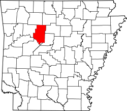
Mill Creek is an unincorporated community in Clark Township, Pope County, Arkansas, United States. [1]
In law, an unincorporated area is a region of land that is not governed by a local municipal corporation; similarly an unincorporated community is a settlement that is not governed by its own local municipal corporation, but rather is administered as part of larger administrative divisions, such as a township, parish, borough, county, city, canton, state, province or country. Occasionally, municipalities dissolve or disincorporate, which may happen if they become fiscally insolvent, and services become the responsibility of a higher administration. Widespread unincorporated communities and areas are a distinguishing feature of the United States and Canada. In most other countries of the world, there are either no unincorporated areas at all, or these are very rare; typically remote, outlying, sparsely populated or uninhabited areas.
Clark Township is one of nineteen current townships in Pope County, Arkansas, USA. As of the 2010 census, its unincorporated population was 3,386. The Arkansas Nuclear One power plant is located here near the city of London, just outside Russellville.
Pope County is a county in the U.S. state of Arkansas. As of the 2010 census, the population was 61,754. The county seat is Russellville. The county was formed on November 2, 1829, from a portion of Crawford County and named for John Pope, the third governor of the Arkansas Territory. It is an alcohol prohibition or dry county.
Johnson is a city in Washington County, Arkansas, United States. The community is located on the Springfield Plateau deep in the Ozark Mountains and is surrounded by valleys and natural springs. Early settlers took advantage of these natural features and formed an economy based on mining lime, the Johnson Mill and trout. Although a post office was opened in the community in 1887, Johnson did not incorporate until it required the development of a city government to provide utility services in 1961. Located between Fayetteville and Springdale in the heart of the rapidly growing Northwest Arkansas metropolitan statistical area, Johnson has been experiencing a population and building boom in recent years, as indicated by a 46% growth in population between the 2000 and 2010 censuses.
The Ozarks, also called the Ozark Mountains or Ozark Plateau, is a physiographic region in the U.S. states of Missouri, Arkansas, Oklahoma, and extreme southeastern Kansas. The Ozarks cover a significant portion of northern Arkansas and most of the southern half of Missouri, extending from Interstate 40 in Arkansas to the Interstate 70 in central Missouri.
The Ozark – St. Francis National Forest is a United States National Forest that is located in the state of Arkansas. It is composed of two separate forests, Ozark National Forest in the Ozark Mountains; and St. Francis National Forest on Crowley's Ridge. Each forest has distinct biological, topographical, and geological differences.
Mill Creek or Millcreek may refer to:
The Fort Smith and Western Railway was a railroad that operated in the states of Arkansas and Oklahoma.
Zanoni is an unincorporated community located in Ozark County, Missouri, on Route 181 about ten miles northeast of Gainesville. A watermill and a post office are all that remain of the community. The community was founded in 1898 and was named for the novel Zanoni by Edward Bulwer-Lytton. The mill was built in 1905 as an overshot wheel mill by "Doc" Morrison and restored by his grandson.
Millcreek Township or Mill Creek Township may refer to the following places in the United States:
The Arkansas Timberlands is a region of the U.S. state of Arkansas generally encompassing the area south of the Ouachita Mountains, south of Central Arkansas and west of the Arkansas Delta. With several different definitions in use by various state agencies, the Arkansas Timberlands is essentially a region known for dense pine and cypress forests covering hilly terrain and lining numerous rivers. Modern settlement created a significant logging industry and subsequent clearance agriculture which provided the basis of the local economy until the discovery of petroleum. Local tourism is largely based on the popularity of deer hunting and bass fishing. Attractions there include Marks' Mills Battleground Historical Monument, Jenkins' Ferry Battleground Historical Monument, Overflow National Wildlife Refuge, Felsenthal National Wildlife Refuge, South Arkansas Arboretum, Arkansas Museum of Natural Resources, White Oak Lake State Park, Poison Springs Battleground State Park, Millwood State Park, and Pond Creek National Wildlife Refuge. The Arkansas Timberlands is the birthplace of former President of the United States Bill Clinton.
Big Sugar Creek is a 47-mile-long (76 km) waterway in the Ozark Mountains of southwest Missouri. The creek starts near the Arkansas state line. Big Sugar starts from three tributaries. One flows north from Garfield, Arkansas, and one, west near Seligman, Missouri, and another, south from Washburn, Missouri. Big Sugar flows west down Sugar Creek Valley, where in the Jacket community it is joined by Otter Creek, from Pea Ridge, Arkansas.
Dutch Mills is an unincorporated community in Dutch Mills Township, Washington County, Arkansas, United States. Dutch Mills is on a small tributary of the Baron Fork of the Illinois River on Arkansas Highway 59, approximately 6 miles (9.7 km) south of U.S. Route 62 and 1 mile (1.6 km) east of the Oklahoma border.
Osage Mills is an unincorporated community in Benton County, Arkansas, United States. The millsite and associated dam is located on Little Osage Creek about eight miles southwest of Rogers. It is the location of the following places listed on the National Register of Historic Places on January 28, 1988:
War Eagle is an unincorporated community in Benton County, Arkansas, United States. It is the location of War Eagle Bridge, which carries CR 98 over War Eagle Creek and is listed on the National Register of Historic Places.
Mill Creek, Arkansas may refer to:
Denver is a community in Carroll County in northwest Arkansas, United States. Denver is located on the east bank of Long Creek near the confluence of Dry Creek with Long Creek and approximately one mile west of the Carroll-Boone county line. The community is accessed by county road from Arkansas Highway 396, which passes about 1.5 miles to the north. Farewell is about three miles to the west.
Yocum is a community in Carroll County in northwest Arkansas, United States. The community is located on Arkansas Highway 103 and the west bank of Yocum Creek. The site is three miles southeast of Oak Grove and six miles north of Green Forest.
Mill Creek Township is one of 21 inactive townships in Madison County, Arkansas, USA. As of the 2010 census, its population was 610.
This Arkansas-related article is a stub. You can help Wikipedia by expanding it. |