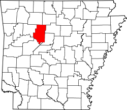
Bullfrog Valley, Arkansas

Last updated

Bullfrog Valley, Arkansas
USA Arkansas location map.svg
Red pog.svg
Bullfrog Valley, Arkansas
Bullfrog Valley's position in Arkansas.
Usa edcp location map.svg
Red pog.svg
Bullfrog Valley, Arkansas
Bullfrog Valley, Arkansas (the United States)
Coordinates: 35°31′08″N93°12′46″W / 35.51889°N 93.21278°W / 35.51889; -93.21278
Country Flag of the United States (23px).png  United States
State Flag of Arkansas.svg  Arkansas
County Pope County, Arkansas
Elevation
204 m (669 ft)
Time zone UTC-6 (Central (CST))
  Summer (DST) UTC-5 (CDT)
GNIS feature ID59138

Bullfrog Valley is an unincorporated community in Illinois Township, Pope County, Arkansas, United States. [1] It is located on Arkansas Highway 164 near the Johnson County line. The community is also located north of Silex.

Related Research Articles

<span class="mw-page-title-main">Nye County, Nevada</span> County in Nevada, United States

Nye County is a county in the U.S. state of Nevada. As of the 2020 census, the population was 51,591. Its county seat is Tonopah. At 18,159 square miles (47,030 km2), Nye is Nevada's largest county by area and the third-largest county in the contiguous United States, behind Coconino County of Arizona and San Bernardino County of California.

<span class="mw-page-title-main">Washington County, Arkansas</span> County in Arkansas, United States

Washington County is a regional economic, educational, and cultural hub in the Northwest Arkansas region. Created as Arkansas's 17th county on November 30, 1848, Washington County has 13 incorporated municipalities, including Fayetteville, the county seat, and Springdale. The county is also the site of small towns, bedroom communities, and unincorporated places. The county is named for George Washington, the first President of the United States.

<span class="mw-page-title-main">Stone County, Arkansas</span> County in Arkansas, United States

Stone County is located in the Ozark Mountains in the U.S. state of Arkansas. The county is named for the rugged, rocky area terrain of the Ozarks. Created as Arkansas's 74th county on April 21, 1873, Stone County has two incorporated cities: Mountain View, the county seat and most populous city, and Fifty-Six. The county is also the site of numerous unincorporated communities and ghost towns.

<span class="mw-page-title-main">Salida, Colorado</span> City in Colorado, United States

Salida is the statutory city that is the county seat and the most populous municipality of Chaffee County, Colorado, United States. The population was 5,666 at the 2020 census.

<span class="mw-page-title-main">Beatty, Nevada</span> Unincorporated town in Nevada, United States

Beatty is an unincorporated town along the Amargosa River in Nye County, Nevada, United States. U.S. Route 95 runs through the town, which lies between Tonopah, about 90 miles (140 km) to the north and Las Vegas, about 120 miles (190 km) to the southeast. State Route 374 connects Beatty to Death Valley National Park, about 8 miles (13 km) to the west.

<span class="mw-page-title-main">Boston Mountains</span> Highland ecoregion in Arkansas and Oklahoma, United States

The Boston Mountains is a Level III ecoregion designated by the Environmental Protection Agency (EPA) in the U.S. states of Arkansas and Oklahoma. Part of the Ozarks, the Boston Mountains are a deeply dissected plateau. The ecoregion is steeper than the adjacent Springfield Plateau to the north, and bordered on the south by the Arkansas Valley. The Oklahoma portion of the range is locally referred to as the Cookson Hills. There are several theories of how the mountains were named, though apparently none are related to the Massachusetts city.

<span class="mw-page-title-main">Rhyolite, Nevada</span> Ghost town in Nevada, United States

Rhyolite is a ghost town in Nye County, in the U.S. state of Nevada. It is in the Bullfrog Hills, about 120 miles (190 km) northwest of Las Vegas, near the eastern boundary of Death Valley National Park.

Pleasant Valley may refer to:

<span class="mw-page-title-main">Silver Lake Provincial Park (Ontario)</span> Provincial park in Ontario, Canada

Silver Lake Provincial Park is a provincial recreation park in the municipality of Tay Valley, Lanark County in Eastern Ontario, Canada. It is on Ontario Highway 7 near the community of Maberly, approximately 30 kilometres (19 mi) away from Perth, Ontario, and is located on a lake of the same name.

Chloride City is a ghost town in Inyo County, California, United States. It is located 8.5 miles (14 km) north-northeast of Beatty Junction, at an elevation of 4,770 ft (1,450 m). The former settlement is in Death Valley National Park.

<span class="mw-page-title-main">Bullfrog Hills</span> Mountain range in Nevada, United States

The Bullfrog Hills are a small mountain range of the Mojave Desert in southern Nye County, southwestern Nevada. Bullfrog Hills was so named from a fancied resemblance of its ore to the color of a bullfrog.

Durham is an unincorporated community in eastern Washington County, Arkansas, United States. The community is on Arkansas Highway 16 along the White River valley between Elkins to the northwest and Thompson in Madison County to the southeast. Its elevation is 1,247 feet (380 m).

<span class="mw-page-title-main">Bullfrog, Nevada</span> Ghost town in Nevada, United States

Bullfrog is a ghost town in Nye County, in the U.S. state of Nevada. It is located at the north end of the Amargosa Desert about 4 miles (6.4 km) west of Beatty. Less than 1 mile (1.6 km) north of Bullfrog are the Bullfrog Hills and the ghost town of Rhyolite. The two ghost towns are about 120 miles (190 km) northwest of Las Vegas, 60 miles (97 km) south of Goldfield, and 90 miles (140 km) south of Tonopah.

<span class="mw-page-title-main">Arkansas Highway 164</span> Highway in Arkansas

Highway 164 is a designation for four segments of state highway in the Arkansas River Valley. Each are low-volume local roads providing connectivity to small communities, or recreation areas near the Ozark National Forest. The first segment was created in 1945, with the remaining segments created during the late 1950s and 1960s, a period of major Arkansas Highway System expansion. A single spur route provides access to an industrial area in Clarksville. All routes are maintained by the Arkansas Department of Transportation (ArDOT).

War Eagle Cove is an unincorporated community in Brush Creek Township, Washington County, Arkansas, United States. The Cove is located on the War Eagle Creek arm of Beaver Lake.

Pleasant Valley is an unincorporated community in Carroll County, Arkansas, United States. The community is located on Arkansas Highway 143.

Hogeye is an unincorporated community in Valley Township, Washington County, Arkansas, United States. It is located on Arkansas Highway 265 and Arkansas Highway 156.

Hubbard is an unincorporated community in Valley Township, Washington County, Arkansas, United States. It is located near the intersection of Washington County Road 21 and Hubbard Road.

Hazel Valley is an unincorporated community in Reed Township, Washington County, Arkansas, United States. It is located along County Route 47 northeast of Winslow.

Onda is an unincorporated community in Valley Township, Washington County, Arkansas, United States. It is located on County Route 29 south of Prairie Grove.

References

  1. "Feature Detail Report for: Bullfrog Valley, Arkansas." USGS.Profile. Retrieved June 22, 2010.