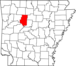
Appleton, Arkansas | |
---|---|
Coordinates: 35°25′27″N92°53′09″W / 35.42417°N 92.88583°W | |
Country | United States |
State | Arkansas |
County | Pope County, Arkansas |
Post Office opened | 1879-1968 |
Elevation | 152 m (499 ft) |
Population (2020) | |
• Total | 399 |
Time zone | UTC-6 (Central (CST)) |
• Summer (DST) | UTC-5 (CDT) |
Area code | 72823 |
GNIS feature ID | 2805618 [1] |
Appleton is an unincorporated community and census-designated place (CDP) in Griffin Township, Pope County, Arkansas, United States. It was first listed as a CDP in the 2020 census with a population of 399. [2]
The town contained a post office from 1879 until 1968. [3] It was named for an apple orchard that surrounded an early drug store. [4]
Census | Pop. | Note | %± |
---|---|---|---|
2020 | 399 | — | |
U.S. Decennial Census [5] 2020 [6] |
Race / Ethnicity (NH = Non-Hispanic) | Pop 2020 [6] | % 2020 |
---|---|---|
White alone (NH) | 334 | 83.71% |
Black or African American alone (NH) | 0 | 0.00% |
Native American or Alaska Native alone (NH) | 6 | 1.50% |
Asian alone (NH) | 2 | 0.50% |
Pacific Islander alone (NH) | 1 | 0.25% |
Some Other Race alone (NH) | 0 | 0.00% |
Mixed Race or Multi-Racial (NH) | 30 | 7.52% |
Hispanic or Latino (any race) | 26 | 6.52% |
Total | 399 | 100.00% |
Genoa is an unincorporated community and census-designated place (CDP) in Miller County, Arkansas, United States. It was first listed as a CDP in the 2020 census with a population of 972. It is located 6 to 12 miles east of Texarkana along Highway 196. Although unincorporated, Genoa has a post office, with the ZIP code of 71840 for a specific post office box. Most of the community is served by ZIP code 71854 (Texarkana). Genoa also has its own school district, Genoa Central School District.
Cherokee City is an unincorporated census-designated place (CDP) in Benton County, Arkansas, United States. Per the 2020 census, the population was 73. It is the location of Coon Creek Bridge, which is located on Cty Rd. 24 and is listed on the National Register of Historic Places. The community was named for the Cherokee, since the Trail of Tears crossed the landscape when the Cherokee migrated west to Indian territory, now Oklahoma in the late 1830s. The town is within the Northwest Arkansas region, located about 5 miles east of Oklahoma and 4 miles south of the Missouri state line.
Maysville is an unincorporated community and census-designated place (CDP) in Benton County, Arkansas, United States. It is the westernmost settlement in the state of Arkansas. Per the 2020 census, the population was 117. It is located in the Northwest Arkansas region.
Midway is a census-designated place in Baxter County, Arkansas, United States. Midway is 5.5 miles (8.9 km) northwest of Mountain Home. Per the 2020 census, the population was 1,036. Midway has a post office with ZIP code 72651. Long home to a rural trading post, Midway became a boomtown during the construction of the Bull Shoals Dam, and later evolved to serve tourists and retirees attracted to the lake.
Uniontown is an unincorporated community and census-designated place (CDP) in Crawford County, Arkansas, United States. It is located on Arkansas Highway 220 near the Oklahoma border, 4.5 miles (7.2 km) west-northwest of Cedarville. Uniontown has a post office with ZIP code 72955.
Pencil Bluff is an unincorporated community and census-designated place (CDP) in Montgomery County, Arkansas, United States. Pencil Bluff is located at the junction of U.S. Route 270 and Arkansas Highway 88, 7.5 miles (12.1 km) northwest of Mount Ida. It was first listed as a CDP in the 2020 census with a population of 72.
Centerville is an unincorporated community and census-designated place (CDP) in Yell County, Arkansas, United States. Centerville is located at the junction of Arkansas Highways 7 and 154, 6.5 miles (10.5 km) north-northeast of Ola. It was first listed as a CDP in the 2020 census with a population of 283.
Boles is an unincorporated community and census-designated place (CDP) in Scott County, Arkansas, United States. It was first listed as a CDP in the 2020 census with a population of 166.
Newhope is an unincorporated community and census-designated place (CDP) in Pike County, Arkansas, United States. Newhope is located at the junction of U.S. Route 70 and Arkansas Highway 369, 8 miles (13 km) west of Daisy. Newhope has a post office with ZIP code 71959.
Morrow is an unincorporated community and census-designated place (CDP) in Washington County, Arkansas, United States. A post office has been in operation at Morrow since 1883; The community had the name of G. W. Morrow, an early postmaster. it was first listed as a CDP in the 2020 census with a population of 263;
Wesley is an unincorporated community and census-designated place (CDP) in western Madison County, Arkansas, United States. Wesley is located at the junction of Arkansas highways 74 and 295, 13 miles (21 km) by road west-southwest of Huntsville. Wesley has a post office with ZIP code 72773. It was first listed as a CDP in the 2020 census with a population of 161.
Ponca is an unincorporated community and census-designated place (CDP) in Newton County, Arkansas, United States. Ponca is located on Arkansas Highway 43, 10 miles (16 km) west of Jasper. Ponca has a post office with ZIP code 72670.
Walcott is an unincorporated community and census-designated place (CDP) in Greene County, Arkansas, United States. Walcott is located at the junction of Arkansas highways 141 and 168, 10 miles (16 km) west of Paragould. It was first listed as a CDP in the 2020 census with a population of 152.
Mellwood is an unincorporated community and census-designated place (CDP) in Phillips County, Arkansas, United States. Mellwood is located on Arkansas Highway 44, 8.5 miles (13.7 km) southwest of Elaine. Mellwood has a post office with ZIP code 72367. It was first listed as a CDP in the 2020 census with a population of 21.
Oneida is an unincorporated community and census-designated place (CDP) in Phillips County, Arkansas, United States. Oneida is located along Arkansas Highway 85, 3.5 miles (5.6 km) north-northeast of Lake View. Oneida has a post office with ZIP code 72369. It was first listed as a CDP in the 2020 census with a population of 13.
Goodwin is an unincorporated community and census-designated place (CDP) in St. Francis County, Arkansas, United States. It was first listed as a CDP in the 2020 census with a population of 113. Goodwin is located along U.S. Route 70, 5.5 miles (8.9 km) east-northeast of Wheatley. Goodwin has a post office with ZIP code 72340.
Henderson is an unincorporated community and census-designated place (CDP) in Baxter County, Arkansas, United States. It was first listed as a CDP in the 2020 census with a population of 309. Henderson is located on the east bank of Norfork Lake along U.S. Routes 62 and 412, 9.5 miles (15.3 km) east-northeast of Mountain Home. Henderson has a post office with ZIP code 72544.
Hattieville is an unincorporated community and census-designated place (CDP) in Conway County, Arkansas, United States. It was first listed as a CDP in the 2020 census with a population of 132. Hattieville is located on Arkansas Highway 213, 9.5 miles (15.3 km) north-northwest of Morrilton. Hattieville has a post office with ZIP code 72063.
Monroe is an unincorporated community and census-designated place (CDP) in Monroe County, Arkansas, United States. The unincorporated community extends beyond the CDP slightly into Lee County. It was first listed as a CDP in the 2020 census with a population of 51.
Batavia is an unincorporated community and census-designated place (CDP) in Boone County, Arkansas, United States. It was first listed as a CDP in the 2020 census with a population of 328.