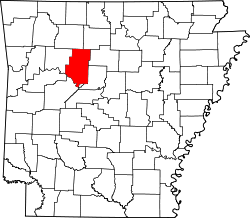
Bethel, Pope County, Arkansas

Last updated

Bethel, Arkansas
USA Arkansas location map.svg
Red pog.svg
Bethel, Arkansas
Bethel's position in Arkansas.
Usa edcp location map.svg
Red pog.svg
Bethel, Arkansas
Bethel, Arkansas (the United States)
Coordinates: 35°14′56″N93°06′33″W / 35.24889°N 93.10917°W / 35.24889; -93.10917
Country Flag of the United States (23px).png  United States
State Flag of Arkansas.svg  Arkansas
County Pope County, Arkansas
Elevation
[1]
107 m (351 ft)
Time zone UTC-6 (Central (CST))
  Summer (DST) UTC-5 (CDT)
GNIS feature ID57365 [1]

Bethel is an unincorporated community in Illinois Township, Pope County, Arkansas, United States. [1]

Related Research Articles

<span class="mw-page-title-main">Pope County, Arkansas</span> County in Arkansas, United States

Pope County is a county in the U.S. state of Arkansas. As of the 2020 census, the population was 63,381. The county seat is Russellville. The county was formed on November 2, 1829, from a portion of Crawford County and named for John Pope, the third governor of the Arkansas Territory. Pope County was the nineteenth county formed. The county's borders changed eighteen times in the 19th century with the creation of new counties and adjustments between counties. The current boundaries were set on March 8, 1877.

<span class="mw-page-title-main">Bethel Heights, Arkansas</span> City in Arkansas, United States

Bethel Heights was a city in Benton County, Arkansas, United States. Always a small, sparsely populated community, the region coalesced around a school named Bethel in the late 19th century but did not incorporate until 1967 to avoid annexation by larger neighboring communities. The town offered police and fire protection and wastewater service to residents, but sent students to Springdale Public Schools and purchased water from Springdale Water Utilities. By the 21st century, Northwest Arkansas was gaining population rapidly, and Bethel Heights reincorporated as a city and grew from a population of 714 in 2000 to 2,372 at the 2010 census. Growth put pressure on the city's subsurface discharge wastewater treatment system, and following a series of wastewater treatment plant violations, voters dissolved the city and completely annexed into Springdale in August 2020.

<span class="mw-page-title-main">Russellville, Arkansas</span> City in Arkansas, United States

Russellville is the county seat and largest city in Pope County, Arkansas, United States, with a 2022 estimated population of 29,133. It is home to Arkansas Tech University. Arkansas Nuclear One, Arkansas' only nuclear power plant is nearby. Russellville borders Lake Dardanelle and the Arkansas River.

<span class="mw-page-title-main">Bethel Township, Delaware County, Pennsylvania</span> Township in Pennsylvania, United States

Bethel Township is a township in Delaware County, Pennsylvania, United States. It contains the two unincorporated communities of Booth's Corner and Chelsea. The population was 8,791 at the 2010 census.

<span class="mw-page-title-main">John Pope (Kentucky politician)</span> American politician (1770–1845)

John Pope was a United States Senator from Kentucky. He was a member of the United States House of Representatives from Kentucky, Secretary of State of Kentucky, and the third Governor of Arkansas Territory.

Bethel African Methodist Episcopal Church, Bethel AME Church, Greater Bethel AME Church or Union Bethel AME Church may refer to:

<span class="mw-page-title-main">Arkansas Tech University</span> Public university in Russellville, Arkansas, US

Arkansas Tech University (ATU) is a public university in Russellville, Arkansas, United States. The university offers programs at both baccalaureate and graduate levels in a range of fields. The Arkansas Tech University–Ozark Campus, a two-year satellite campus in the town of Ozark, primarily focuses on associate and certificate education.

<span class="mw-page-title-main">Paragould meteorite</span> Meteorite found in the United States

The Paragould Meteorite at 41 inches (1,000 mm) by 24 inches (610 mm) by 16 inches (410 mm) and weighing 370 kilograms (820 lb) is the second largest witnessed meteorite fall ever recovered in North America and the largest stony meteorite chondrite. It fell to Earth at approximately 4:08 a.m. on February 17, 1930.

<span class="mw-page-title-main">Arkansas Highway 265</span> State highway in Arkansas, United States

Highway 265 is a designation for three state highways in Northwest Arkansas. The southern segment of 19.70 miles (31.70 km) runs from Highway 170 near Strickler north to I-49/US 71/Highway 112 in south Fayetteville. A second segment begins in east Fayetteville at Highway 16 and runs north through Springdale to Highway 94 in Rogers. Further north, a third segment of 3.324 miles (5.349 km) runs from Highway 94 in Pea Ridge north to the Missouri state line. The highways are maintained by the Arkansas Department of Transportation (ARDOT).

<span class="mw-page-title-main">Otis Wingo</span> American politician

Otis Theodore Wingo was an American lawyer and politician who served as a U.S. representative from Arkansas's 4th congressional district from 1913 to 1930. He was the husband of his successor in office, Effiegene Wingo.

<span class="mw-page-title-main">William F. Slemons</span> American politician

William Ferguson Slemons was a U.S. Representative from Arkansas.

<span class="mw-page-title-main">John M. Clayton (Arkansas politician)</span> American politician (1840–1889)

John Middleton Clayton was an American politician who served as a Republican member of the Arkansas House of Representatives for Jefferson County from 1871 to 1873 and the Arkansas State Senate for Jefferson County. In 1888, he ran for a seat in the United States House of Representatives but lost to Clifton R. Breckinridge. Clayton challenged the results and was assassinated in 1889 during the challenge to the election. He was declared the winner of the election posthumously. The identity of his assassin remains unknown.

Bethel, Arkansas may refer to:

Illinois Township is one of nineteen current townships in Pope County, Arkansas, USA. As of the 2010 census, its total population was 29,813, with 91.8 percent contained in urban Russellville.

Retta is an unincorporated community in Jackson Township, Pope County, Arkansas, United States. It is a populated place located within the Township of Jackson, a minor civil division (MCD) of Pope County. The elevation of Retta is 679 feet. Retta appears on the Solo U.S. Geological Survey Map. Pope County is in the Central Time Zone. The local timezone is named " America/Chicago''.

<span class="mw-page-title-main">1996 United States presidential election in Arkansas</span>

The 1996 United States presidential election in Arkansas took place on November 5, 1996, as part of the 1996 United States presidential election. State voters chose six electors to the Electoral College, who voted for president and vice president.

<span class="mw-page-title-main">Accident, Arkansas</span> Unincorporated community in Arkansas, United States

Accident is an unincorporated community in Township 2, Benton County, Arkansas, United States. It is located near Highway 264 north of Bethel Heights.

Township 3 is one of thirteen current townships in Benton County, Arkansas, United States. As of the 2010 census, its total population was 20,037.

References