Bayliss Township, Pope County, Arkansas

Last updated

Bayliss Township
USA Arkansas location map.svg
Red pog.svg
Bayliss Township
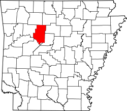
Location in Arkansas
Coordinates: 35°24′10″N93°14′06″W / 35.40278°N 93.23500°W / 35.40278; -93.23500
Country Flag of the United States (23px).png  United States
State Flag of Arkansas.svg Arkansas
County Pope
Established1876
Area
  Total
28.9 sq mi (75 km2)
  Land28.85 sq mi (74.7 km2)
  Water0.05 sq mi (0.1 km2)
Elevation
636 ft (194 m)
Population
 (2010)
  Total
824
  Density28.6/sq mi (11.0/km2)
Time zone UTC-6 (CST)
  Summer (DST) UTC-5 (CDT)
GNIS feature ID 69697

Bayliss Township is one of nineteen current townships in Pope County, Arkansas, USA. [1] As of the 2010 census, its unincorporated population was 824.

Contents

Geography

According to the United States Census Bureau, Bayliss Township covers an area of 28.9 square miles (75 km2), with 28.8 square miles (75 km2) of land and 0.1 square miles (0.26 km2) of water. [1] Bayliss Township was created in 1876 from parts of Clark and Martin Townships. [2]

Cities, towns, and villages

References

  1. 1 2 "Bayliss Township, Pope County, Arkansas." U.S. Census Bureau. Breakdown. Retrieved June 20, 2010.
  2. Baker, Russell (2003). Arkansas Township Atlas 1819-1930. Little Rock, AR: Arkansas Genealogical Society. p. 148. ISBN   0-9723085-6-3.