Sand Gap, Arkansas

Last updated

Sand Gap, Arkansas
USA Arkansas location map.svg
Red pog.svg
Sand Gap, Arkansas
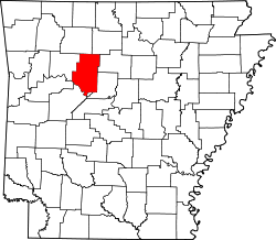
Position in Arkansas
Coordinates: 35°43′15″N93°05′46″W / 35.72083°N 93.09611°W / 35.72083; -93.09611
Country Flag of the United States (23px).png  United States
State Flag of Arkansas.svg  Arkansas
County Pope
Elevation
598 m (1,962 ft)
Time zone UTC-6 (Central (CST))
  Summer (DST) UTC-5 (CDT)
GNIS feature ID78290

Sand Gap is an unincorporated community in Freeman Township, Pope County, Arkansas, United States. [1] Sand Gap is located at the junction of Arkansas highways 7 and 16.

Sand Gap used to be known as Grand Gap. The [2] official Arkansas town name is Pelsor. [1] It contains Archeological Site 3PP614, which is listed on the National Register of Historic Places.

Related Research Articles

<span class="mw-page-title-main">Montgomery County, Arkansas</span> County in Arkansas, United States

Montgomery County is a county in the U.S. state of Arkansas. As of the 2020 census, the population was 8,484. The county seat is Mount Ida. Montgomery County is Arkansas's 45th county, formed on December 9, 1842, and named after Richard Montgomery, an American Revolutionary War general.

<span class="mw-page-title-main">Tulsa County, Oklahoma</span> County in the United States

Tulsa County is a county located in the U.S. state of Oklahoma. As of the 2020 census, the population was 669,279, making it the second-most populous county in the state, behind only Oklahoma County. Its county seat and largest city is Tulsa, the second-largest city in the state. Founded at statehood, in 1907, it was named after the previously established city of Tulsa. Before statehood, the area was part of both the Creek Nation and the Cooweescoowee District of Cherokee Nation in Indian Territory.

<span class="mw-page-title-main">Kiowa County, Colorado</span> County in Colorado, United States

Kiowa County is a county located in the U.S. state of Colorado. As of the 2020 census, the population was 1,446, making it the fifth-least populous county in Colorado. The county seat is Eads. The county was named for the Kiowa Nation of Native Americans.

<span class="mw-page-title-main">Prairie County, Arkansas</span> County in Arkansas, United States

Prairie County is in the Central Arkansas region of the U.S. state of Arkansas. The county is named for the Grand Prairie, a subregion of the Arkansas Delta known for rice cultivation and aquaculture that runs through the county. Created as Arkansas's 54th county in 1846, Prairie County is home to four incorporated towns, including DeValls Bluff, the southern district county seat, and two incorporated cities, including Des Arc, the northern district county seat. The county is also the site of numerous unincorporated communities and ghost towns. Occupying 676 square miles (175,000 ha), Prairie County is the median-sized county in Arkansas. As of the 2020 Census, the county's population was 8,282. Based on population, the county is the ninth-smallest county of the 75 in Arkansas.

<span class="mw-page-title-main">Polk County, Arkansas</span> County in Arkansas, United States

Polk County is a county located in the U.S. state of Arkansas. As of the 2020 census, the population was 19,221. The county seat is Mena. Polk County is Arkansas's 48th county, formed on November 30, 1844; it was named for James K. Polk, 11th President of the United States.

<span class="mw-page-title-main">Lincoln County, Arkansas</span> County in Arkansas, United States

Lincoln County is located between the Arkansas Timberlands and Arkansas Delta in the U.S. state of Arkansas. It is also within the Pine Bluff metro area, and on the outer edge of the Central Arkansas region. The county is named for President Abraham Lincoln. Created as Arkansas's 65th county on March 28, 1871, Lincoln County has three incorporated cities, including Star City, the county seat and most populous city. The county contains 46 unincorporated communities and ghost towns, Cane Creek State Park at the confluence of Cane Creek and Bayou Bartholomew, and nine listings on the National Register of Historic Places to preserve the history and culture of the county.

<span class="mw-page-title-main">Johnson County, Arkansas</span> County in Arkansas, United States

Johnson County is a county located in the U.S. state of Arkansas. As of the 2020 census, the population was 25,749. The county seat is Clarksville. Johnson County is Arkansas's 30th county, formed on November 16, 1833, from a portion of Pope County and named for Benjamin Johnson, a Territorial Judge. It is an alcohol prohibition or dry county.

<span class="mw-page-title-main">Black Oak, Arkansas</span> Town in Arkansas, United States

Black Oak is a town in Craighead County, Arkansas, United States. The population was 262 at the 2010 census. It is included in the Jonesboro, Arkansas Metropolitan Statistical Area.

<span class="mw-page-title-main">Gate City, Virginia</span> Town in Virginia, United States

Gate City is a town in Scott County, Virginia, United States. The population was 2,034 at the 2010 census. It is the seat of Scott County.

<span class="mw-page-title-main">Arkansas Highway 16</span> American state highway

Highway 16 is an east–west state highway in Arkansas. The route begins in Siloam Springs at US Highway 412 (US 412) and Highway 59 and runs east through Fayetteville and the Ozark National Forest to US Highway 67 Business (US 67B) in Searcy. Highway 16 was created during the 1926 Arkansas state highway numbering, and today serves as a narrow, winding, 2-lane road except for overlaps of 10 miles (16 km) through Fayetteville. Much of the highway winds through the Ozarks, including the Ozark National Forest, where a portion of the highway is designated as an Arkansas Scenic Byway. The route has two spur routes in Northwest Arkansas; in Fayetteville and Siloam Springs.

<span class="mw-page-title-main">Battle of Ringgold Gap</span> Battle of the American Civil War

The Battle of Ringgold Gap was fought November 27, 1863, outside the town of Ringgold, Georgia, by the Confederate and Union armies during the American Civil War. Part of the Chattanooga Campaign, it followed a heavy Confederate loss at the Battle of Missionary Ridge from which General Braxton Bragg's artillery and wagon trains were forced to retreat south. The five hour Battle of Ringgold Gap resulted in the Confederate victory of Major General Patrick R. Cleburne and gave the Army of Tennessee safe passage to retreat through the Ringgold Gap mountain pass.

Caddo Gap is an unincorporated community and census-designated place (CDP) in Montgomery County, Arkansas, United States. It lies between Glenwood and Norman, on the Caddo River. It was first listed as a CDP in the 2020 census with a population of 39.

<span class="mw-page-title-main">Oro City, Colorado</span> Ghost town in Lake County, Colorado, United States

Oro City is a ghost town in Lake County, Colorado, United States

<span class="mw-page-title-main">Index of Arkansas-related articles</span>

The following is an alphabetical list of articles related to the U.S. State of Arkansas.

Larue is an unincorporated community in Benton County, Arkansas, United States. Larue was established in the late 19th century as a community for orchard workers. In the 1920s, the community transitioned to an economy based on animal husbandry and grain farming as orchard production declined in the area.

<span class="mw-page-title-main">Thomas J. Hankins House</span> Historic house in Arkansas, United States

The Thomas J. Hankins House is a historic house in the crossroads hamlet of Sand Gap in far northern Pope County, Arkansas. It is located about 375 feet (114 m) north of the junction of Arkansas Highways 123 and 7, on the west side of Highway 7. It is a single-story wood-frame structure, with a gabled roof, novelty siding, and stone foundation. The roof, its gable end facing front, extends over the front porch, supported by square posts, and there is a square diamond window in the gable center. Built in 1929, it is good local example of vernacular Craftsman design.

Hurricane Creek is a tributary to the Big Piney Creek, a river in Ozark-St. Francis National Forest in the state of Arkansas, which is a tributary of the Arkansas River and which is, in turn, part of the Mississippi River System. It is managed by the United States Forest Service and categorized as one of the Wild and Scenic Rivers of the United States.

<span class="mw-page-title-main">Tornadoes of 1949</span>

This page documents the tornadoes and tornado outbreaks of 1949, primarily in the United States. Most recorded tornadoes form in the U.S., although some events may take place internationally. Tornado statistics for older years like this often appear significantly lower than modern years due to fewer reports or confirmed tornadoes.

References

  1. 1 2 "Feature Detail Report for: Sand Gap, Arkansas." USGS. Profile. Retrieved June 25, 2010.
  2. "Arkansas Town and County Listing" (PDF). Arkansas Dept. of Human Services.