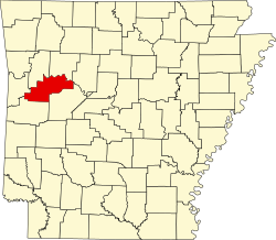
Logan County, Arkansas

Last updated

Logan County
Logan County Courthouse (east), Paris, AR 002.jpg
Logan County Courthouse, Paris
Map of Arkansas highlighting Logan County.svg
Location within the U.S. state of Arkansas
Arkansas in United States.svg
Arkansas's location within the U.S.
Coordinates: 35°13′29″N93°44′26″W / 35.224722222222°N 93.740555555556°W / 35.224722222222; -93.740555555556
CountryFlag of the United States.svg United States
StateFlag of Arkansas.svg  Arkansas
FoundedMarch 22, 1871
Named for James Logan
Seat Paris (northern district);
Booneville (southern district)
Largest cityBooneville
Area
  Total
732 sq mi (1,900 km2)
  Land708 sq mi (1,830 km2)
  Water23 sq mi (60 km2)  3.2%
Population
 (2020)
  Total
21,131
  Density29/sq mi (11/km2)
Time zone UTC−6 (Central)
  Summer (DST) UTC−5 (CDT)
Congressional district 4th

Logan County (formerly Sarber County) is a county located in the U.S. state of Arkansas. As of the 2020 census, the population was 21,131. [1] Its two county seats are Booneville and Paris. [2]

Contents

History

The Arkansas General Assembly defined the state's 64th county on March 22, 1871, incorporating parts of Scott, Yell, and Pope counties (later adding part of Franklin County). They named it Sarber County for John Newton Sarber (1837–1905), an attorney and Republican state senator from Yell County. He had introduced the resolution to organize the county. Born and reared in Pittsburgh, Pennsylvania, he had moved with his widowed father and family to Kansas in 1855. Sarber became influential in the Arkansas legislature, introducing bills to establish a public school system for the first time, and what developed as the University of Arkansas. In 1873, Sarber was appointed U.S. marshal of the U.S. Western District Court at Fort Smith. [3]

Conservative white Democrats viewed Sarber as a carpetbagger because he was a Union Army veteran who had decided to settle in Arkansas. There he had married Susan Rebecca Rose in 1867. She was the daughter of Moreau Rose, an early pioneer and a Confederate supporter, and his wife. The Sarber couple had six children together; five survived to adulthood.

After white Democrats regained control of the state legislature in 1875, they renamed Sarber County for James Logan (1792-1859), a Kentucky-born early settler in the area who had served in the territorial legislature, from Crawford County, and the first state legislature, from Scott County (part of the latter was absorbed into Logan County). [4]

Geography

According to the U.S. Census Bureau, the county has a total area of 732 square miles (1,900 km2), of which 708 square miles (1,830 km2) are land and 23 square miles (60 km2) (3.2%) are water. [5] The highest natural point in Arkansas, Magazine Mountain at 2,753 feet (839 m), is located in Logan County.

Major highways

Adjacent counties

Demographics

Historical population
CensusPop.Note
1880 14,885
1890 20,77439.6%
1900 20,563−1.0%
1910 26,35028.1%
1920 25,866−1.8%
1930 24,110−6.8%
1940 25,9677.7%
1950 20,260−22.0%
1960 15,957−21.2%
1970 16,7895.2%
1980 20,14420.0%
1990 20,5572.1%
2000 22,4869.4%
2010 22,353−0.6%
2020 21,131−5.5%
2023 (est.)21,400 [6] 1.3%
U.S. Decennial Census [7]
1790–1960 [8] 1900–1990 [9]
1990–2000 [10] 2010 [11]
Age pyramid Logan County USA Logan County, Arkansas age pyramid.svg
Age pyramid Logan County

2020 census

Logan County racial composition [13]
RaceNumberPercentage
White (non-Hispanic)18,58687.96%
Black or African American (non-Hispanic)2251.06%
Native American 2281.08%
Asian 3281.55%
Pacific Islander 80.04%
Other/Mixed 1,1165.28%
Hispanic or Latino 6403.03%

As of the 2020 United States census, there were 21,131 people, 8,417 households, and 5,839 families residing in the county.

2000 census

As of the 2000 census, [14] there were 22,486 people, 8,693 households, and 6,302 families residing in the county. The population density was 32 people per square mile (12 people/km2). There were 9,942 housing units at an average density of 14 per square mile (5.4/km2). The racial makeup of the county was 96.46% White, 1.05% Black or African American, 0.65% Native American, 0.15% Asian, 0.02% Pacific Islander, 0.39% from other races, and 1.28% from two or more races. 1.21% of the population were Hispanic or Latino of any race.

There were 8,693 households, out of which 32.90% had children under the age of 18 living with them, 58.70% were married couples living together, 10.10% had a female householder with no husband present, and 27.50% were non-families. 24.40% of all households were made up of individuals, and 12.50% had someone living alone who was 65 years of age or older. The average household size was 2.53 and the average family size was 3.00.

In the county, the population was spread out, with 25.90% under the age of 18, 7.50% from 18 to 24, 26.70% from 25 to 44, 23.90% from 45 to 64, and 16.00% who were 65 years of age or older. The median age was 38 years. For every 100 females there were 98.40 males. For every 100 females age 18 and over, there were 94.20 males.

The median income for a household in the county was $28,344, and the median income for a family was $33,732. Males had a median income of $24,472 versus $18,681 for females. The per capita income for the county was $14,527. About 11.40% of families and 15.40% of the population were below the poverty line, including 18.20% of those under age 18 and 19.60% of those age 65 or over.

Politics

Over the past few election cycles, Logan County has trended heavily towards the GOP. The last Democrat (as of 2024) to carry this county was Bill Clinton in 1996.

United States presidential election results for Logan County, Arkansas [15]
Year Republican Democratic Third party(ies)
No.%No.%No.%
2024 6,56780.04%1,46417.84%1742.12%
2020 6,44178.31%1,54418.77%2402.92%
2016 5,74672.54%1,71521.65%4605.81%
2012 5,07969.28%2,00927.40%2433.31%
2008 5,35067.66%2,28628.91%2713.43%
2004 5,07659.36%3,36139.31%1141.33%
2000 4,48755.42%3,28340.55%3264.03%
1996 2,96637.07%3,83247.89%1,20415.05%
1992 3,40839.23%3,99545.99%1,28414.78%
1988 2,20362.87%1,25435.79%471.34%
1984 5,66363.14%3,20635.75%1001.11%
1980 4,51150.61%4,09845.98%3043.41%
1976 2,90935.07%5,31364.06%720.87%
1972 4,96471.42%1,95628.14%300.43%
1968 2,34136.02%1,99830.74%2,16033.24%
1964 2,26538.42%3,60461.13%270.46%
1960 2,01442.28%2,63655.33%1142.39%
1956 2,08147.17%2,30752.29%240.54%
1952 2,10344.85%2,56754.75%190.41%
1948 90228.26%2,13066.73%1605.01%
1944 1,27935.98%2,26963.83%70.20%
1940 1,06527.34%2,83172.66%00.00%
1936 77022.38%2,66377.41%70.20%
1932 64520.32%2,49378.54%361.13%
1928 1,45542.42%1,96757.35%80.23%
1924 93732.06%1,45749.85%52918.10%
1920 1,87149.51%1,84048.69%681.80%
1916 1,18336.96%2,01863.04%00.00%
1912 33312.98%1,31951.40%91435.62%
1908 1,15138.65%1,71657.62%1113.73%
1904 1,00743.92%1,23753.95%492.14%
1900 84834.88%1,55764.05%261.07%
1896 94634.51%1,78665.16%90.33%

Communities

Cities

Towns

Census-designated place

Unincorporated communities

Townships

Townships in Arkansas are the divisions of a county. Each township includes unincorporated areas; some may have incorporated cities or towns within part of their boundaries. Arkansas townships have limited purposes in modern times. However, the United States census does list Arkansas population based on townships (sometimes referred to as "county subdivisions" or "minor civil divisions"). Townships are also of value for historical purposes in terms of genealogical research. Each town or city is within one or more townships in an Arkansas county based on census maps and publications. The townships of Logan County are listed below; listed in parentheses are the cities, towns, and/or census-designated places that are fully or partially inside the township. [16] [17]

Notable residents

See also

Related Research Articles

<span class="mw-page-title-main">Yell County, Arkansas</span> County in Arkansas, United States

Yell County is a county in the U.S. state of Arkansas. As of the 2020 census, the population was 20,263. The county has two county seats, Dardanelle and Danville. Yell County is Arkansas's 42nd county, formed on December 5, 1840, from portions of Scott and Pope counties. It was named after Archibald Yell, who was the state's first member of the United States House of Representatives and the second governor of Arkansas. He died in combat at the Battle of Buena Vista during the Mexican–American War.

<span class="mw-page-title-main">Scott County, Arkansas</span> County in Arkansas, United States

Scott County is a county located in the U.S. state of Arkansas. As of the 2020 census, the population was 9,836. The county seat is Waldron. Scott County is Arkansas' 28th county, formed on November 5, 1833, and named for Andrew Scott, a justice of the Supreme Court of the Arkansas Territory. It is an alcohol-prohibited or dry county.

<span class="mw-page-title-main">Polk County, Arkansas</span> County in Arkansas, United States

Polk County is a county located in the U.S. state of Arkansas. As of the 2020 census, the population was 19,221. The county seat is Mena. Polk County is Arkansas's 48th county, formed on November 30, 1844; it was named for James K. Polk, 11th President of the United States.

<span class="mw-page-title-main">Perry County, Arkansas</span> County in Arkansas, United States

Perry County is a county located in the U.S. state of Arkansas. Its population was 10,019 at the 2020 United States Census. The county seat is Perryville. The county was formed on December 18, 1840, and named for Commodore Oliver Hazard Perry, naval hero in the War of 1812. It is an alcohol prohibition or dry county.

<span class="mw-page-title-main">Johnson County, Arkansas</span> County in Arkansas, United States

Johnson County is a county located in the U.S. state of Arkansas. As of the 2020 census, the population was 25,749. The county seat is Clarksville. Johnson County is Arkansas's 30th county, formed on November 16, 1833, from a portion of Pope County and named for Benjamin Johnson, a Territorial Judge. It is an alcohol prohibition or dry county.

<span class="mw-page-title-main">Izard County, Arkansas</span> County in Arkansas, United States

Izard County is a county located in the U.S. state of Arkansas. As of the 2020 census, the population was 13,577. The county seat is Melbourne. Izard County is Arkansas's 13th county, formed on October 27, 1825, and named for War of 1812 General and Arkansas Territorial Governor George Izard. It is an alcohol prohibition or dry county.

<span class="mw-page-title-main">Independence County, Arkansas</span> County in Arkansas, United States

Independence County is a county located in the U.S. state of Arkansas. As of the 2020 census, the population was 37,938. The county seat is Batesville. Independence County is Arkansas's ninth county, formed on October 20, 1820, from a portion of Lawrence County and named in commemoration of the Declaration of Independence. It is an alcohol prohibition or dry county.

<span class="mw-page-title-main">Fulton County, Arkansas</span> County in Arkansas, United States

Fulton County is a county located in the U.S. state of Arkansas. As of the 2020 census, the population was 12,075. The county seat is Salem. Fulton County was formed on December 21, 1842, and named for William Fulton, the last governor of the Arkansas Territory. It is an alcohol prohibition or dry county.

<span class="mw-page-title-main">Franklin County, Arkansas</span> County in Arkansas, United States

Franklin County is a county in Arkansas. As of the 2020 census, the population was 17,097. The county has two county seats, Charleston and Ozark. The county was formed on December 19, 1837, and named for Benjamin Franklin, American statesman. Franklin County is a damp county, with alcohol sales allowed except in Prairie & Alix townships, and limits on liquor sales in the city of Branch.

<span class="mw-page-title-main">Drew County, Arkansas</span> County in Arkansas, United States

Drew County is a county located in the southeast region of the U.S. state of Arkansas. As of the 2020 census, the population was 17,350. The county seat and largest city is Monticello. Drew County was formed on November 26, 1846, and named for Thomas Drew, the third governor of Arkansas.

<span class="mw-page-title-main">Dallas County, Arkansas</span> County in Arkansas, United States

Dallas County is a county located in the U.S. state of Arkansas. As of the 2020 census, the population was 6,482, making it the fourth-least populous county in Arkansas. The county seat is Fordyce. Dallas County is Arkansas's 49th county, formed on January 1, 1845; it was named for George M. Dallas, 11th Vice President of the United States.

<span class="mw-page-title-main">Conway County, Arkansas</span> County in Arkansas, United States

Conway County is a county located in the U.S. state of Arkansas. Created as Arkansas's 11th county on October 20, 1825, Conway County has four incorporated municipalities, including Morrilton, the county seat and most populous city. The county is also the site of numerous unincorporated communities and ghost towns. The county is named for Henry Wharton Conway, a politician from a powerful political family who served as the delegate from the Arkansas Territory to the U.S. Congress from 1823 to 1827.

<span class="mw-page-title-main">Cleveland County, Arkansas</span> County in Arkansas, United States

Cleveland County is a county located in the U.S. state of Arkansas. Its population was 7,550 at the 2020 U.S. census. The county seat and largest city is Rison. Cleveland County is included in the Pine Bluff, AR Metropolitan Statistical Area, which is also included in the Little Rock-North Little Rock, AR Combined Statistical Area.

<span class="mw-page-title-main">Cleburne County, Arkansas</span> County in Arkansas, United States

Cleburne County is a county located in the U.S. state of Arkansas. As of the 2020 census, the population was 24,711. The county seat and most populous city is Heber Springs. The county was formed on February 20, 1883, as the last of Arkansas's 75 counties to be formed. It is named for Confederate Major-General Patrick Cleburne. Cleburne is an alcohol prohibition or dry county.

<span class="mw-page-title-main">Boone County, Arkansas</span> County in Arkansas, United States

Boone County is a county located in the U.S. state of Arkansas, along the Missouri border. As of the 2020 census, the population was 37,373. The county seat is Harrison. It is Arkansas's 62nd county, formed on April 9, 1869.

<span class="mw-page-title-main">Benton County, Arkansas</span> County in Arkansas, United States

Benton County is a county in the Northwest region of the U.S. state of Arkansas. Created as Arkansas' 35th county on September 30, 1836, Benton County contains thirteen incorporated municipalities, including Bentonville, the county seat, and Rogers, the most populous city. The county was named after Thomas Hart Benton, a U.S. Senator from Missouri influential in Arkansas statehood.

<span class="mw-page-title-main">Blue Mountain, Arkansas</span> Town in Arkansas

Blue Mountain is a town in Logan County, Arkansas, United States. The population was 124 at the 2010 census.

<span class="mw-page-title-main">Booneville, Arkansas</span> City in Arkansas, United States

Booneville is a city in Logan County, Arkansas, United States and the county seat of its southern district. Located in the Arkansas River Valley between the Ouachita and Ozark Mountains, the city is one of the oldest in western Arkansas. The city's economy was first based upon the railroad and Arkansas State Tuberculosis Sanatorium. It has developed a diverse economy of small businesses and light industry. Booneville's population was 3,990 at the 2010 census.

<span class="mw-page-title-main">Caulksville, Arkansas</span> Town in Arkansas, United States

Caulksville is a town in Logan County, Arkansas, United States. The town was named for Robert Caulk, who received a land patent at the location of the town in 1860.

<span class="mw-page-title-main">Havana, Arkansas</span> City in Arkansas, United States

Havana is a city in northwest Yell County, Arkansas, United States. The population was 375 at the 2010 census. It is part of the Russellville Micropolitan Statistical Area. Arkansas Scenic State Highway 309 leads from Havana to the top of Mount Magazine, home of Arkansas's newest State Park, and the highest peak in Arkansas.

References

  1. "Census - Geography Profile: Logan County, Arkansas". United States Census Bureau . Retrieved January 20, 2023.
  2. "Find a County". National Association of Counties. Retrieved June 7, 2011.
  3. "John Newton Sarber (1837–1905)". The Encyclopedia of Arkansas. Central Arkansas Library System. Retrieved January 1, 2023.
  4. Acts, Resolutions and Memorials of the General Assembly of the State of Arkansas (Session from November 1 to December 15, 1875 ed.). Little Rock, AR: P.A. Ladue. 1876. pp. 129–131. Retrieved May 8, 2012.
  5. "2010 Census Gazetteer Files". United States Census Bureau. August 22, 2012. Retrieved August 27, 2015.
  6. "Annual Estimates of the Resident Population for Counties: April 1, 2020 to July 1, 2023". United States Census Bureau. Retrieved March 30, 2024.
  7. "U.S. Decennial Census". United States Census Bureau. Retrieved August 27, 2015.
  8. "Historical Census Browser". University of Virginia Library. Retrieved August 27, 2015.
  9. Forstall, Richard L., ed. (March 27, 1995). "Population of Counties by Decennial Census: 1900 to 1990". United States Census Bureau. Retrieved August 27, 2015.
  10. "Census 2000 PHC-T-4. Ranking Tables for Counties: 1990 and 2000" (PDF). United States Census Bureau. April 2, 2001. Archived (PDF) from the original on March 27, 2010. Retrieved August 27, 2015.
  11. "State & County QuickFacts". United States Census Bureau. Archived from the original on June 7, 2011. Retrieved May 23, 2014.
  12. Based on 2000 census data
  13. "Explore Census Data". data.census.gov. Retrieved January 1, 2022.
  14. "U.S. Census website". United States Census Bureau . Retrieved May 14, 2011.
  15. "Dave Leip's Atlas of U.S. Presidential Elections" . Retrieved November 18, 2016.
  16. 2011 Boundary and Annexation Survey (BAS): Logan County, AR (PDF) (Map). U. S. Census Bureau. Archived from the original (PDF) on October 19, 2012. Retrieved August 24, 2011.
  17. "Arkansas: 2010 Census Block Maps - County Subdivision". United States Census Bureau . Retrieved May 29, 2014.
  18. 1 2 Reichler, Joseph L., ed. (1979) [1969]. The Baseball Encyclopedia (4th ed.). New York: Macmillan Publishing. ISBN   0-02-578970-8.

Further reading

35°13′29″N93°44′26″W / 35.22472°N 93.74056°W / 35.22472; -93.74056