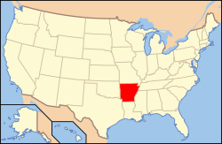
Physical and human geographic features of Arkansas
The geography of Arkansas varies widely. The state is covered by mountains, river valleys, forests, lakes, and bayous in addition to the cities of Arkansas. Hot Springs National Park features bubbling springs of hot water, formerly sought across the country for their healing properties.[1][2]Crowley's Ridge is a geological anomaly rising above the surrounding lowlands of the Mississippi embayment.
First added to the United States of America as part of the Louisiana Territory of the Louisiana Purchase in 1803, Arkansas later became part of the Missouri Territory upon its establishment in 1812.[8] This was further divided into the Arkansaw Territory on March 2, 1819, as everything south of Parallel 36°30′ north (except the Missouri Bootheel) to the Louisiana state line. This new territory also included most of present-day Oklahoma until gaining its current boundaries in the 1840s. The slight oddity in Arkansas's western boundary results from a dispute with the Choctaw Nation in 1824. The Choctaws wanted the western boundary of Arkansas to start 100 paces east of Fort Smith and run south to the Red River, claiming the land had little timber and poor soil. Despite protests from Henry Conway, President James Monroe signed the bill into law on January 20, 1825.[9]
The flat topography and fertile soils of Southeast Arkansas have been important to the region throughout its history, first to the Native American that inhabited the region. This history is available today at museums like the Pine Bluff/Jefferson County Historical Museum. The area was one of the first explored and settled in Arkansas; including the territorial capital at Arkansas Post. Following widespread settlement, most of the area was put into cotton cultivation due to the region's fertile soils. The staple's high market value made many plantation owners wealthy in the antebellum period; this history is available to visitors at museums such as the Lakeport Plantation. After the Civil War, agriculture became based on sharecropping and tenant farming, allowing plantation owners to keep their workers in poverty and maintain their political power and social dominance. In the 1950s, mechanization reduced the need for laborers on the farm, driving much of the region's population elsewhere in order to find jobs. Throughout much of Southeast Arkansas, population has continued to decline and economies have continued to shrink ever since. The primary population center of the region is the Pine Bluff metropolitan area, with Pine Bluff serving as the principal city.
Southwest Arkansas
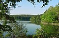
Southwest Arkansas is largely covered in a thick pine, hickory, and oak forest known as the Piney Woods, with much of the land being preserved in the Ouachita National Forest. Manmade lakes dot the region, including Lake Ouachita, Lake Hamilton, Millwood Lake, and DeGray Lake. Population centers include Hot Springs, a popular tourist destination known for the natural hot springs protected within Hot Springs National Park, Oaklawn Park racing resort, and historic buildings; and Texarkana, which straddles the Texas state line in the southwest corner of Arkansas. Most of Southwest Arkansas is sparsely populated, with small towns separated by long roadways through stands of pine trees.
While not bordering the Gulf of Mexico, Arkansas is still close enough to the warm, large body of water for it to influence the weather in the state. Generally, Arkansas has hot, humid summers and slightly drier, mild to cool winters. In Little Rock, the daily high temperatures average around 93°F (34°C) with lows around 73°F (23°C) in July. In January highs average around 51°F (11°C) and lows around 32°F (0°C). In Siloam Springs in the northwest part of the state, the average high and low temperatures in July are 89 and 67°F (32 and 19°C) and in January the average high and low are 44 and 23°F (7 and −5°C).
Annual precipitation throughout the state averages between about 40 and 60 inches (1,000 and 1,500mm); it is somewhat wetter in the south and drier in the northern part of the state. Snowfall is infrequent but most common in the northern half of the state.[15] The half of the state south of Little Rock is apter to see ice storms. Arkansas's record high is 120°F (49°C) at Ozark on August 10, 1936; the record low is −29°F (−34°C) at Gravette, on February 13, 1905.[16]
Arkansas is known for extreme weather and frequent storms. A typical year brings thunderstorms, tornadoes, hail, snow and ice storms. Between both the Great Plains and the Gulf States, Arkansas, receives around 60 days of thunderstorms. Arkansas is located in Tornado Alley, and as a result, a few of the most destructive tornadoes in U.S. history have struck the state. While sufficiently far from the coast to avoid a direct hit from a hurricane, Arkansas can often get the remnants of a tropical system, which dumps tremendous amounts of rain in a short time and often spawns smaller tornadoes.[citation needed]
Climate data
Monthly Normal High and Low Temperatures For Various Arkansas Cities
The Natural Resources Conservation Service has noted that amounts of rainfall in Arkansas are characterized by marked differences along a northeast/southwest dividing line. The northeast is characterized as arid-semiarid climate, and the southwest as a Gulf-influenced humid-subhumid climate.[31] The area that receives the most rain in the state is the area south of the Ouachita Mountains, which form an orographic effect (commonly known as rain shadow) when storms move north from the Gulf.
The Arkansas Department of Environmental Quality (ADEQ) describes Arkansas's water resources by using six ecoregions. Of the six, the Boston Mountain, Ouachita Mountain and Ozark Highlands ecoregions generally contain waterways with "exceptionally high quality water", including many of the state's extraordinary resources waters (ERWs). The Arkansas River Valley, Gulf Coastal and Delta ecoregions have seen adverse water quality effects from agriculture and silviculture but are generally compliant with the goals of the Clean Water Act.[32]
Surface water
Arkansas contains approximately 515,000 acres (208,000ha) of surface waters, including 28,408 miles (45,718km) of perennial streams and 87,618 miles (141,008km) of total streams. ADEQ uses six ultimate receiving streams to subdivide the state into primary watersheds: Arkansas River, Mississippi River, Ouachita River, Red River, St. Francis River, and White River. This six basins collect water from over 1600 smaller watersheds throughout the state via tributary streams, as described below.[32]
Arkansas River: flows south-southeast, roughly bisecting the state. Major tributaries include Bayou Meto, Cadron Creek, Fourche LaFave River, Petit Jean River, Poteau River, and Illinois River.
Mississippi River: flows south and forms much of the state's eastern boundary on its way to the Gulf of Mexico. Major tributaries include the Arkansas, St. Francis, and White.
Red River: located in southwest Arkansas, flows southeast into Louisiana. Major tributaries include: Dorcheat Bayou, Bodcau Bayou, Lower Middle Red River, Lower Red River, Sulphur River, McKinney Bayou, Little River, and Mountain Fork
St. Francis River: located in northeast Arkansas, flows east into the Mississippi River. Major tributaries include the L'Anguille River and Little River.
Groundwater accounts for over 60% of water use in Arkansas, and shallow aquifers providing high quality groundwater can be found throughout the state. In many upland regions of Arkansas, surface water interacts with groundwater via karst topography common to the Ozarks and Ouachitas. Groundwater monitoring is subdivided into twelve areas. Of the twelve, the Athens Plateau (Hempstead County), Frontal Ouachita, Hardy, Omaha, Ouachita, North Central, and Pine Bluff monitoring areas have a water quality described as "generally good".
Administered by the National Park Service (NPS), Hot Springs National Park was the nation's first national park. The park includes structures from when it was a flourishing resort: Bathhouse Row is a formerly bustling avenue of Gilded Age architecture bathhouses; each drew on the spring water of the site with claims to cure dozens of ailments. There was also a racetrack and associated resort nearby.
↑ Mean monthly maxima and minima (i.e. the expected highest and lowest temperature readings at any point during the year or given month) calculated based on data at said location from 1991 to 2020.
↑ Official records for Little Rock began on 1 July 1879 at the State Capitol and maintained there until 30 April 1942. The next day, and until 7 August 1942, temperature and precipitation were recorded separately at two different locations in and around Little Rock, and the official climatology station has been Adams Field since 8 August 1942. For more information, see Threadex
↑ "State Climate Records". State Climate Extremes Committee. National Oceanic and Atmospheric Administration, National Climatic Data Center. July 23, 2012. Retrieved January 4, 2013.
↑ "Station: Fayetteville EXP STN, AR". U.S. Climate Normals 2020: U.S. Monthly Climate Normals (1991-2020). National Oceanic and Atmospheric Administration. Retrieved June 21, 2021.
This page is based on this Wikipedia article Text is available under the CC BY-SA 4.0 license; additional terms may apply. Images, videos and audio are available under their respective licenses.