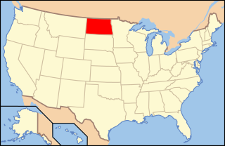
McKenzie County is a county in the U.S. state of North Dakota. As of the 2020 census, the population was 14,704. Its county seat is Watford City.

Pembina is a city in Pembina County, North Dakota, United States. The population was 512 at the 2020 census. Pembina is located 2 miles (3.2 km) south of the Canada–US border. Interstate 29 passes on the western side of Pembina, leading north to the Canada–US border at Emerson, Manitoba and south to the cities of Grand Forks and Fargo. The Pembina–Emerson Border Crossing is the busiest between Surrey–Blaine, and Windsor–Detroit, and the fifth busiest along the Canada-United States border. It is one of three 24-hour ports of entry in North Dakota, the others being Portal and Dunseith. The Noyes–Emerson East Border Crossing, located 2 miles (3.2 km) to the east on the Minnesota side of the Red River, also processed cross-border traffic until its closure in 2006.

Lake Agassiz was a large proglacial lake that existed in central North America during the late Pleistocene, fed by meltwater from the retreating Laurentide Ice Sheet at the end of the last glacial period. At its peak, the lake's area was larger than all of the modern Great Lakes combined. It eventually drained into what is now Hudson Bay, leaving behind Lake Winnipeg, Lake Winnipegosis, Lake Manitoba, and Lake of the Woods.

White Butte is the highest natural point in the U.S. state of North Dakota. At an elevation of 3,506 ft, it is a prominent butte in Slope County, in the Badlands of the southwestern part of the state. It is located 3 miles east of U.S. 85 and about 6.5 mi (10 km) south of Amidon.

The White River is a Missouri River tributary that flows 580 miles (930 km) through the U.S. states of Nebraska and South Dakota. The name stems from the water's white-gray color, a function of eroded sand, clay, and volcanic ash carried by the river from its source near the Badlands. Draining a basin of about 10,200 square miles (26,000 km2), about 8,500 square miles (22,000 km2) of which is in South Dakota, the stream flows through a region of sparsely populated hills, plateaus, and badlands.

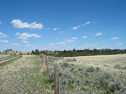
The Pembina River is a tributary of the Red River of the North, approximately 319 miles (513 km) long, in southern Manitoba in Canada and northeastern North Dakota in the United States. It drains an area of the prairie country along the Canada–US border, threading the Manitoba-North Dakota border eastward to the Red River. Via the Red River, Lake Winnipeg and the Nelson River, it is part of the watershed of Hudson Bay.

The Dissected Till Plains are physiographic sections of the Central Lowlands province, which in turn is part of the Interior Plains physiographic division of the United States, located in southern and western Iowa, northeastern Kansas, the southwestern corner of Minnesota, northern Missouri, eastern Nebraska, and southeastern South Dakota.

Little Missouri National Grassland is a National Grassland located in western North Dakota, United States. At 1,028,051 acres (416,037 ha), it is the largest grassland in the country. Enclaved within its borders is Theodore Roosevelt National Park with an additional 70,446 acres (28,508 ha), which is managed by the National Park Service. The Little Missouri National Grassland was once a part of the Custer National Forest, but is now a part of the Dakota Prairie Grasslands, a National Forest unit consisting entirely of National Grasslands. A predominant feature of the grassland is colorful and beautiful badlands, a rugged terrain extensively eroded by wind and water. It is a mixed-grass prairie with both long and short grass.

Turtle Mountain, or the Turtle Mountains, is an area in central North America, in the north-central portion of the U.S. state of North Dakota and southwestern portion of the Canadian province of Manitoba, approximately 62 miles (100 km) south of the city of Brandon on Manitoba Highway 10 / U.S. Route 281. It is a plateau 2,000 ft above sea level, 300 ft to 400 ft above the surrounding countryside, extending 20 mi (32 km) from north to south and 40 mi (64 km) from east to west. Rising 1,031 feet (314 m), North Dakota's most prominent peak, Boundary Butte, is located at the western edge of the plateau.
The Drift Prairie is a geographic region in the U.S. states of North Dakota and South Dakota.
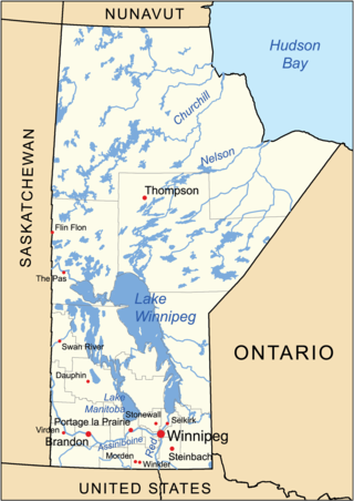
The geography of Manitoba addresses the easternmost of the three prairie Canadian provinces, located in the longitudinal centre of Canada. Manitoba borders on Saskatchewan to the west, Ontario to the east, Nunavut to the north, and the American states of North Dakota and Minnesota to the south. Although the border with Saskatchewan appears straight on large-scale maps, it actually has many right-angle corners that give the appearance of a slanted line. In elevation, Manitoba ranges from sea level on Hudson Bay to 2727 ft (831 m) on top of Baldy Mountain. The northern sixty percent of the province is on the Canadian Shield. The northernmost regions of Manitoba lie permafrost, and a section of tundra bordering Hudson Bay.

Buffalo Ridge is a large expanse of rolling hills in the southeastern part of the larger Coteau des Prairies. It stands 1,995 feet (608 m) above sea level. The Buffalo Ridge is sixty miles (97 km) long and runs through Lincoln, Pipestone, Murray, Nobles, and Rock counties in the southwest corner of Minnesota, and Minnehaha, Moody, and Lincoln counties in southeast South Dakota.

The U.S. State of Minnesota is the northernmost state outside Alaska; its isolated Northwest Angle in Lake of the Woods is the only part of the 48 contiguous states lying north of the 49th parallel north. Minnesota is in the U.S. region known as the Upper Midwest in interior North America. The state shares a Lake Superior water border with Michigan and Wisconsin on the northeast; the remainder of the eastern border is with Wisconsin. Iowa is to the south, South Dakota and North Dakota are to the west, and the Canadian provinces of Manitoba and Ontario are to the north. With 87,014 square miles (225,370 km2), or approximately 2.26% of the United States, Minnesota is the 12th largest state.

Interstate 94 (I-94) runs east–west for 352.4 miles (567.1 km) through the southern half of the US state of North Dakota, from the Montana state line east to the Red River at Fargo. The route generally follows the route of the Northern Pacific Railway.

The Pembina Escarpment is a scarp that runs from South Dakota to Manitoba, and forms the western wall of the Red River Valley. The height of the escarpment above the river valley is 300–400 feet (91–122 m).

South Dakota is a state located in the north-central United States. It is usually considered to be in the Midwestern region of the country. The state can generally be divided into three geographic regions: eastern South Dakota, western South Dakota, and the Black Hills. Eastern South Dakota is lower in elevation and higher in precipitation than the western part of the state, and the Black Hills are a low, isolated mountain group in the southwestern corner of the state. Smaller sub-regions in the state include the Coteau des Prairies, Missouri Coteau, James River Valley, and the Dissected Till Plains. Geologic formations in South Dakota range in age from two billion-year-old Precambrian granite in the Black Hills to glacial till deposited over the last few million years. South Dakota is the 17th-largest state in the country.

The Missouri River Valley outlines the journey of the Missouri River from its headwaters where the Madison, Jefferson and Gallatin Rivers flow together in Montana to its confluence with the Mississippi River in the State of Missouri. At 2,300 miles (3,700 km) long the valley drains one-sixth of the United States, and is the longest river valley on the North American continent. The valley in the Missouri River basin includes river bottoms and floodplains.

Montana is one of the eight Mountain States, located in the north of the region known as the Western United States. It borders North Dakota and South Dakota to the east. Wyoming is to the south, Idaho is to the west and southwest, and the Canadian provinces of British Columbia, Alberta, and Saskatchewan are to the north, making it the only state to border three Canadian provinces.

Thunder Butte is a prominent butte landmark located in the northwest corner of Ziebach County, South Dakota, in the United States. Thunder Butte is a large, isolated hill that can be seen for many miles in every direction, and has served throughout history as an important orientation point for area residents or a navigational aide for travelers crossing the surrounding plains. The butte gives its name to a small community at its base, and to a small creek that runs into the Moreau River.
Paleontology in North Dakota refers to paleontological research occurring within or conducted by people from the U.S. state of North Dakota. During the early Paleozoic era most of North Dakota was covered by a sea home to brachiopods, corals, and fishes. The sea briefly left during the Silurian, but soon returned, until once more starting to withdraw during the Permian. By the Triassic some areas of the state were still under shallow seawater, but others were dry and hot. During the Jurassic subtropical forests covered the state. North Dakota was always at least partially under seawater during the Cretaceous. On land Sequoia grew. Later in the Cenozoic the local seas dried up and were replaced by subtropical swamps. Climate gradually cooled until the Ice Age, when glaciers entered the area and mammoths and mastodons roamed the local woodlands.