Arizona is a landlocked state situated in the southwestern region of the United States of America. It has a vast and diverse geography famous for its deep canyons, high- and low-elevation deserts, numerous natural rock formations, and volcanic mountain ranges. Arizona shares land borders with Utah to the north, the Mexican state of Sonora to the south, New Mexico to the east, and Nevada to the northwest, as well as water borders with California and the Mexican state of Baja California to the southwest along the Colorado River. Arizona is also one of the Four Corners states and is diagonally adjacent to Colorado.
Arizona has a total area of 113,998 square miles (295,253 km2), making it the sixth largest U.S. state. [1] Of this area, just 0.3% consists of water, which makes Arizona the state with the second lowest percentage of water area (New Mexico is the lowest at 0.2%). [1] Arizona spans about 335 miles (539 km) at its widest and 390 miles (628 km) at its longest, and has an average elevation of about 4,000 feet (1,200 m). [2] The geographic center of Arizona is located in Yavapai County, approximately 55 miles (89 km) east-southeast of the city of Prescott.
Arizona is divided into 15 counties, and has 90 incorporated cities and towns. Approximately 65 percent of Arizona residents live in Maricopa County, which had a population of 3,817,117 as of the 2010 Census. Maricopa County ranks fourth among the nation's counties in terms of population, and is more populated than 24 of the U.S. states. The county seat of Maricopa County is Phoenix, which is Arizona's largest city and capital.
The next most populous county is Pima County, which had a 2010 census population of 980,263. The county seat of Pima County is Tucson, where nearly all of the population is concentrated. Combined, nearly 80% of Arizona residents live in either Maricopa County or Pima County, even though the two counties make up 16% of Arizona's total area. Because of the high population of Maricopa County and Pima County, both counties are dominant in state politics.
About 15% of Arizona is privately owned, the remaining land consisting primarily of Forest Service, National Park Service, Native American reservations, military institutions, and swaths of wilderness held by the Bureau of Land Management. Arizona is home to 21 federally recognized tribes, which are each semi-autonomous. The large majority are part of the Navajo Nation, which is the largest Native American reservation in terms of population and size. The Navajo Reservation covers all of northeastern Arizona along with portions of New Mexico and Utah, and had a population of 107,449 as of the 2010 census.
Due to the state's large area and range of elevation, there is a variety of localized climate conditions. Overall, most of Arizona receives little precipitation, and is classified as having either an arid or semi-arid climate. The northern parts of the state and the mountainous areas tend to have cooler climates, while the southwestern parts of the state tend to be warm year round.
Precipitation in Arizona is governed by elevation and the season of year. The peak periods of rainfall are during the early winter, when storm systems from the Pacific Ocean cross the state, and during the summer, when moisture-bearing winds sweep into Arizona from the southeast, which obtain moisture from the Gulf of Mexico. Summer rains tend to occur in the form of thunderstorms, which result from excessive heating of the ground and the lifting of moisture-laden air along mountain ranges. These thunderstorms can cause strong winds, brief periods of blowing dust, and infrequently cause hail. The heaviest precipitation is found in the mountain ranges of central and southeastern Arizona, while the driest conditions are found in the arid regions of southwestern Arizona.
The number of days with measurable precipitation can vary from around 70 in the Flagstaff area to 15 in the Yuma area. [3] The highest elevations of Arizona receive up to 30 inches (760 mm) of precipitation annually, and the southern slopes of the Mogollon Rim and the southeast average between 15 and 20 inches (380 and 510 mm). The driest part of the state is the southwestern region, which receives under 3 inches (76 mm) of rain a year, whilst the northeastern Colorado Plateau is in a rain shadow and receives between 4.5 and 10 inches (114 and 254 mm). Annual average humidity values vary from 55% in Flagstaff to 23% in Yuma. Due to the high temperatures, low humidity, and occurrence of sunshine, Arizona has high rates of evaporation. Average annual lake evaporation varies from about 80 inches (2,000 mm) in the southwestern part of the state to about 50 inches (1,300 mm) in the northeast. [4] During El Niño, the Pacific jet stream enters the U.S. further south of its normal position, making Arizona winters wetter than usual. The opposite phase, La Niña, reinforces the jet streams northern route, making Arizona winters even drier than normal.[ citation needed ]
While the desert parts of Arizona are renowned for their warm climates, snow is not uncommon to portions of Arizona. From November through March, when storm systems from the Pacific Ocean cross the state, heavy snow can accumulate in the mountains of central, northern, and southeastern Arizona. Moderate snow can occur as far south as Nogales, Arizona, which is located on the southern border with Mexico, since it experiences below-freezing nighttime temperatures during the winter.
The rims of the Grand Canyon experience snow during the winter due to their high altitudes. The South Rim of the Grand Canyon, located at an altitude averaging 7,000 feet or 2,100 metres, receives 60 inches or 1.52 metres of snow annually, and the North Rim of the Grand Canyon, located at an altitude over 8,000 feet or 2,400 metres receives 144 inches or 3.66 metres of snow. [5]
Because of the dry climate and sparse cloud cover throughout the state, temperatures can vary dramatically, from day to night, and from season to season. Parts of Arizona located in the Sonoran Desert have warm daytime temperatures year round, while other parts of the state experience seasonal coldness regularly. The average daily temperatures of Yuma, which is located near Arizona's southwestern corner, range from 43 to 67 °F (6 to 19 °C) in January, and from 81 to 107 °F (27 to 42 °C) in July. In Flagstaff, located in the state's central interior, the average daily temperatures range from 14 to 41 °F (−10 to 5 °C) during January, and from 50 to 81 °F (10 to 27 °C) in July. The record high temperature for Arizona was 128 °F (53 °C), measured in Lake Havasu City on June 29, 1994, and July 5, 2007. The record low temperature for Arizona was -40 °F (-40 °C), measured at Hawley Lake on January 7, 1971. [6]
Climate data for Flagstaff Pulliam Airport, Arizona (1991–2020 normals, sun 1981–2010, humidity 1961–1990, [lower-alpha 1] extremes 1898–present) [lower-alpha 2] | |||||||||||||
---|---|---|---|---|---|---|---|---|---|---|---|---|---|
Month | Jan | Feb | Mar | Apr | May | Jun | Jul | Aug | Sep | Oct | Nov | Dec | Year |
Record high °F (°C) | 66 (19) | 71 (22) | 73 (23) | 80 (27) | 89 (32) | 96 (36) | 97 (36) | 93 (34) | 91 (33) | 85 (29) | 74 (23) | 68 (20) | 97 (36) |
Mean maximum °F (°C) | 56.9 (13.8) | 58.9 (14.9) | 65.7 (18.7) | 72.8 (22.7) | 80.5 (26.9) | 88.6 (31.4) | 90.5 (32.5) | 87.4 (30.8) | 82.9 (28.3) | 75.5 (24.2) | 66.9 (19.4) | 58.7 (14.8) | 91.4 (33.0) |
Mean daily maximum °F (°C) | 43.4 (6.3) | 45.7 (7.6) | 52.2 (11.2) | 59.2 (15.1) | 68.1 (20.1) | 79.1 (26.2) | 82.0 (27.8) | 79.3 (26.3) | 74.1 (23.4) | 63.6 (17.6) | 52.1 (11.2) | 43.0 (6.1) | 61.8 (16.6) |
Daily mean °F (°C) | 30.5 (−0.8) | 32.8 (0.4) | 38.0 (3.3) | 43.7 (6.5) | 51.3 (10.7) | 60.8 (16.0) | 66.7 (19.3) | 64.9 (18.3) | 58.3 (14.6) | 47.6 (8.7) | 37.5 (3.1) | 30.0 (−1.1) | 46.8 (8.2) |
Mean daily minimum °F (°C) | 17.6 (−8.0) | 19.6 (−6.9) | 23.8 (−4.6) | 28.2 (−2.1) | 34.6 (1.4) | 42.5 (5.8) | 51.4 (10.8) | 50.6 (10.3) | 42.5 (5.8) | 31.5 (−0.3) | 23.0 (−5.0) | 16.9 (−8.4) | 31.8 (−0.1) |
Mean minimum °F (°C) | −1.4 (−18.6) | 2.5 (−16.4) | 8.1 (−13.3) | 17.1 (−8.3) | 24.6 (−4.1) | 31.1 (−0.5) | 41.4 (5.2) | 42.3 (5.7) | 30.9 (−0.6) | 20.0 (−6.7) | 8.1 (−13.3) | −1.4 (−18.6) | −5.5 (−20.8) |
Record low °F (°C) | −30 (−34) | −23 (−31) | −16 (−27) | −2 (−19) | 7 (−14) | 22 (−6) | 32 (0) | 24 (−4) | 20 (−7) | −2 (−19) | −13 (−25) | −23 (−31) | −30 (−34) |
Average precipitation inches (mm) | 2.05 (52) | 2.17 (55) | 1.88 (48) | 0.89 (23) | 0.77 (20) | 0.30 (7.6) | 2.61 (66) | 3.04 (77) | 1.84 (47) | 1.52 (39) | 1.55 (39) | 1.90 (48) | 20.52 (521) |
Average snowfall inches (cm) | 20.9 (53) | 19.3 (49) | 15.6 (40) | 5.0 (13) | 1.1 (2.8) | 0.0 (0.0) | 0.0 (0.0) | 0.0 (0.0) | 0.0 (0.0) | 1.5 (3.8) | 8.2 (21) | 18.5 (47) | 90.1 (229) |
Average extreme snow depth inches (cm) | 10.7 (27) | 9.8 (25) | 9.3 (24) | 3.3 (8.4) | 0.3 (0.76) | 0.0 (0.0) | 0.0 (0.0) | 0.0 (0.0) | 0.0 (0.0) | 0.6 (1.5) | 3.7 (9.4) | 8.8 (22) | 17.4 (44) |
Average precipitation days (≥ 0.01 in) | 7.0 | 7.6 | 6.8 | 4.9 | 4.5 | 2.2 | 12.0 | 13.3 | 7.5 | 5.3 | 4.4 | 6.7 | 82.2 |
Average snowy days (≥ 0.1 in) | 6.2 | 6.1 | 4.7 | 1.9 | 0.9 | 0.0 | 0.0 | 0.0 | 0.0 | 0.5 | 2.3 | 5.7 | 28.3 |
Average relative humidity (%) | 61.9 | 59.5 | 54.9 | 46.5 | 39.4 | 33.6 | 51.1 | 58.1 | 54.7 | 52.6 | 56.9 | 60.6 | 52.5 |
Average dew point °F (°C) | 15.3 (−9.3) | 16.7 (−8.5) | 18.7 (−7.4) | 20.5 (−6.4) | 24.3 (−4.3) | 28.4 (−2.0) | 44.1 (6.7) | 45.9 (7.7) | 38.3 (3.5) | 27.3 (−2.6) | 19.9 (−6.7) | 15.1 (−9.4) | 26.2 (−3.2) |
Mean monthly sunshine hours | 231.7 | 228.6 | 286.3 | 321.0 | 369.5 | 371.8 | 324.2 | 311.9 | 298.5 | 282.8 | 229.3 | 219.8 | 3,475.4 |
Percent possible sunshine | 74 | 75 | 77 | 82 | 85 | 86 | 73 | 75 | 80 | 81 | 74 | 72 | 78 |
Average ultraviolet index | 2 | 2 | 3 | 4 | 5 | 6 | 6 | 6 | 5 | 3 | 2 | 2 | 4 |
Source 1: NOAA (relative humidity 1961–1990, sun 1973–1990) [7] [8] [9] [10] | |||||||||||||
Source 2: Weather Atlas (UV) [11] |
Climate data for Phoenix Int'l, Arizona (1991–2020 normals, [lower-alpha 3] extremes 1895–present) [lower-alpha 4] | |||||||||||||
---|---|---|---|---|---|---|---|---|---|---|---|---|---|
Month | Jan | Feb | Mar | Apr | May | Jun | Jul | Aug | Sep | Oct | Nov | Dec | Year |
Record high °F (°C) | 88 (31) | 92 (33) | 100 (38) | 105 (41) | 114 (46) | 122 (50) | 121 (49) | 117 (47) | 116 (47) | 107 (42) | 99 (37) | 87 (31) | 122 (50) |
Mean maximum °F (°C) | 78.2 (25.7) | 82.1 (27.8) | 90.4 (32.4) | 99.0 (37.2) | 105.7 (40.9) | 112.7 (44.8) | 114.6 (45.9) | 113.2 (45.1) | 108.9 (42.7) | 100.7 (38.2) | 88.9 (31.6) | 77.7 (25.4) | 115.7 (46.5) |
Mean daily maximum °F (°C) | 67.6 (19.8) | 70.8 (21.6) | 78.1 (25.6) | 85.5 (29.7) | 94.5 (34.7) | 104.2 (40.1) | 106.5 (41.4) | 105.1 (40.6) | 100.4 (38.0) | 89.2 (31.8) | 76.5 (24.7) | 66.2 (19.0) | 87.1 (30.6) |
Daily mean °F (°C) | 56.8 (13.8) | 59.9 (15.5) | 66.3 (19.1) | 73.2 (22.9) | 82.0 (27.8) | 91.4 (33.0) | 95.5 (35.3) | 94.4 (34.7) | 89.2 (31.8) | 77.4 (25.2) | 65.1 (18.4) | 55.8 (13.2) | 75.6 (24.2) |
Mean daily minimum °F (°C) | 46.0 (7.8) | 49.0 (9.4) | 54.5 (12.5) | 60.8 (16.0) | 69.5 (20.8) | 78.6 (25.9) | 84.5 (29.2) | 83.6 (28.7) | 78.1 (25.6) | 65.6 (18.7) | 53.7 (12.1) | 45.3 (7.4) | 64.1 (17.8) |
Mean minimum °F (°C) | 36.0 (2.2) | 40.0 (4.4) | 44.4 (6.9) | 50.1 (10.1) | 58.4 (14.7) | 69.4 (20.8) | 74.4 (23.6) | 74.2 (23.4) | 68.3 (20.2) | 53.8 (12.1) | 42.0 (5.6) | 35.4 (1.9) | 33.8 (1.0) |
Record low °F (°C) | 16 (−9) | 24 (−4) | 25 (−4) | 35 (2) | 39 (4) | 49 (9) | 63 (17) | 58 (14) | 47 (8) | 34 (1) | 27 (−3) | 22 (−6) | 16 (−9) |
Average precipitation inches (mm) | 0.87 (22) | 0.87 (22) | 0.83 (21) | 0.22 (5.6) | 0.13 (3.3) | 0.02 (0.51) | 0.91 (23) | 0.93 (24) | 0.57 (14) | 0.56 (14) | 0.57 (14) | 0.74 (19) | 7.22 (183) |
Average precipitation days (≥ 0.01 in) | 3.8 | 4.1 | 3.1 | 1.5 | 1.0 | 0.5 | 3.9 | 4.6 | 2.5 | 2.2 | 2.2 | 4.0 | 33.4 |
Average relative humidity (%) | 50.9 | 44.4 | 39.3 | 27.8 | 21.9 | 19.4 | 31.6 | 36.2 | 35.6 | 36.9 | 43.8 | 51.8 | 36.6 |
Average dew point °F (°C) | 32.4 (0.2) | 32.2 (0.1) | 32.9 (0.5) | 31.6 (−0.2) | 34.3 (1.3) | 39.0 (3.9) | 56.1 (13.4) | 58.3 (14.6) | 52.3 (11.3) | 43.0 (6.1) | 35.8 (2.1) | 33.1 (0.6) | 40.1 (4.5) |
Mean monthly sunshine hours | 256.0 | 257.2 | 318.4 | 353.6 | 401.0 | 407.8 | 378.5 | 360.8 | 328.6 | 308.9 | 256.0 | 244.8 | 3,871.6 |
Percent possible sunshine | 81 | 84 | 86 | 90 | 93 | 95 | 86 | 87 | 89 | 88 | 82 | 79 | 87 |
Average ultraviolet index | 3.1 | 4.4 | 6.6 | 8.5 | 9.7 | 10.9 | 11.0 | 10.1 | 8.3 | 5.6 | 3.7 | 2.7 | 7.0 |
Source 1: NOAA (dew points, relative humidity, and sun 1961–1990) [12] [13] [14] , Weather.com [15] | |||||||||||||
Source 2: UV Index Today (1995 to 2022) [16] |
Climate data for Tucson, Arizona (Tucson Int'l), 1991–2020 normals, [lower-alpha 5] extremes 1894−present [lower-alpha 6] | |||||||||||||
---|---|---|---|---|---|---|---|---|---|---|---|---|---|
Month | Jan | Feb | Mar | Apr | May | Jun | Jul | Aug | Sep | Oct | Nov | Dec | Year |
Record high °F (°C) | 88 (31) | 92 (33) | 99 (37) | 104 (40) | 111 (44) | 117 (47) | 114 (46) | 112 (44) | 111 (44) | 103 (39) | 94 (34) | 85 (29) | 117 (47) |
Mean maximum °F (°C) | 79.1 (26.2) | 82.5 (28.1) | 88.7 (31.5) | 95.4 (35.2) | 102.8 (39.3) | 109.2 (42.9) | 109.0 (42.8) | 107.0 (41.7) | 103.5 (39.7) | 97.9 (36.6) | 87.6 (30.9) | 78.9 (26.1) | 110.7 (43.7) |
Mean daily maximum °F (°C) | 66.5 (19.2) | 69.2 (20.7) | 75.8 (24.3) | 82.9 (28.3) | 91.8 (33.2) | 101.2 (38.4) | 100.2 (37.9) | 98.6 (37.0) | 95.1 (35.1) | 86.3 (30.2) | 75.1 (23.9) | 65.5 (18.6) | 84.0 (28.9) |
Daily mean °F (°C) | 53.6 (12.0) | 56.2 (13.4) | 61.9 (16.6) | 68.1 (20.1) | 76.8 (24.9) | 86.1 (30.1) | 88.2 (31.2) | 86.9 (30.5) | 82.8 (28.2) | 72.6 (22.6) | 61.5 (16.4) | 53.0 (11.7) | 70.6 (21.4) |
Mean daily minimum °F (°C) | 40.8 (4.9) | 43.2 (6.2) | 48.0 (8.9) | 53.3 (11.8) | 61.8 (16.6) | 71.1 (21.7) | 76.3 (24.6) | 75.2 (24.0) | 70.4 (21.3) | 59.0 (15.0) | 47.9 (8.8) | 40.5 (4.7) | 57.3 (14.1) |
Mean minimum °F (°C) | 28.5 (−1.9) | 31.6 (−0.2) | 35.6 (2.0) | 41.1 (5.1) | 50.3 (10.2) | 60.3 (15.7) | 67.8 (19.9) | 68.3 (20.2) | 60.8 (16.0) | 44.9 (7.2) | 32.9 (0.5) | 27.8 (−2.3) | 25.6 (−3.6) |
Record low °F (°C) | 6 (−14) | 17 (−8) | 20 (−7) | 27 (−3) | 32 (0) | 43 (6) | 49 (9) | 55 (13) | 43 (6) | 26 (−3) | 19 (−7) | 10 (−12) | 6 (−14) |
Average precipitation inches (mm) | 0.84 (21) | 0.84 (21) | 0.56 (14) | 0.24 (6.1) | 0.20 (5.1) | 0.23 (5.8) | 2.21 (56) | 1.98 (50) | 1.32 (34) | 0.67 (17) | 0.56 (14) | 0.96 (24) | 10.61 (269) |
Average snowfall inches (cm) | 0.0 (0.0) | 0.1 (0.25) | 0.0 (0.0) | 0.0 (0.0) | 0.0 (0.0) | 0.0 (0.0) | 0.0 (0.0) | 0.0 (0.0) | 0.0 (0.0) | 0.0 (0.0) | 0.0 (0.0) | 0.0 (0.0) | 0.1 (0.25) |
Average precipitation days (≥ 0.01 in) | 4.2 | 4.0 | 3.1 | 1.6 | 1.4 | 1.6 | 8.8 | 8.5 | 4.4 | 2.9 | 2.5 | 4.4 | 47.4 |
Average snowy days (≥ 0.1 in) | 0.1 | 0.1 | 0.0 | 0.0 | 0.0 | 0.0 | 0.0 | 0.0 | 0.0 | 0.0 | 0.0 | 0.0 | 0.2 |
Average relative humidity (%) | 48.4 | 42.7 | 37.0 | 27.0 | 22.0 | 21.1 | 41.6 | 46.6 | 41.7 | 38.4 | 42.7 | 50.0 | 38.3 |
Average dew point °F (°C) | 28.2 (−2.1) | 27.7 (−2.4) | 27.7 (−2.4) | 26.8 (−2.9) | 29.1 (−1.6) | 36.3 (2.4) | 55.8 (13.2) | 58.1 (14.5) | 51.1 (10.6) | 39.2 (4.0) | 31.8 (−0.1) | 29.5 (−1.4) | 36.8 (2.7) |
Mean monthly sunshine hours | 259.9 | 258.2 | 320.7 | 357.2 | 400.8 | 396.9 | 342.7 | 335.6 | 316.4 | 307.4 | 264.4 | 245.8 | 3,806 |
Percent possible sunshine | 81 | 84 | 86 | 92 | 94 | 93 | 79 | 81 | 85 | 87 | 84 | 79 | 86 |
Source: NOAA (relative humidity, dew points and sun 1961–1990) [17] [18] [19] |
Climate data for Yuma, Arizona (1991–2020 normals [lower-alpha 7] , sunshine 1981–2010, extremes 1878–present) | |||||||||||||
---|---|---|---|---|---|---|---|---|---|---|---|---|---|
Month | Jan | Feb | Mar | Apr | May | Jun | Jul | Aug | Sep | Oct | Nov | Dec | Year |
Record high °F (°C) | 88 (31) | 97 (36) | 102 (39) | 107 (42) | 120 (49) | 122 (50) | 124 (51) | 120 (49) | 123 (51) | 112 (44) | 98 (37) | 86 (30) | 124 (51) |
Mean maximum °F (°C) | 79.5 (26.4) | 84.1 (28.9) | 92.8 (33.8) | 100.3 (37.9) | 106.2 (41.2) | 112.9 (44.9) | 115.0 (46.1) | 114.4 (45.8) | 110.6 (43.7) | 102.2 (39.0) | 89.5 (31.9) | 78.0 (25.6) | 116.6 (47.0) |
Mean daily maximum °F (°C) | 69.8 (21.0) | 73.4 (23.0) | 80.2 (26.8) | 86.4 (30.2) | 94.3 (34.6) | 103.3 (39.6) | 106.7 (41.5) | 106.4 (41.3) | 101.4 (38.6) | 90.2 (32.3) | 77.7 (25.4) | 67.8 (19.9) | 88.1 (31.2) |
Daily mean °F (°C) | 58.8 (14.9) | 61.9 (16.6) | 67.6 (19.8) | 73.1 (22.8) | 80.6 (27.0) | 89.1 (31.7) | 94.6 (34.8) | 94.8 (34.9) | 89.5 (31.9) | 78.0 (25.6) | 66.1 (18.9) | 57.3 (14.1) | 76.0 (24.4) |
Mean daily minimum °F (°C) | 47.9 (8.8) | 50.4 (10.2) | 55.0 (12.8) | 59.8 (15.4) | 66.9 (19.4) | 75.0 (23.9) | 82.6 (28.1) | 83.2 (28.4) | 77.6 (25.3) | 65.7 (18.7) | 54.4 (12.4) | 46.8 (8.2) | 63.8 (17.7) |
Mean minimum °F (°C) | 38.1 (3.4) | 40.8 (4.9) | 44.7 (7.1) | 49.6 (9.8) | 56.8 (13.8) | 65.1 (18.4) | 75.2 (24.0) | 75.0 (23.9) | 66.9 (19.4) | 54.6 (12.6) | 44.1 (6.7) | 37.2 (2.9) | 35.6 (2.0) |
Record low °F (°C) | 22 (−6) | 25 (−4) | 31 (−1) | 38 (3) | 39 (4) | 50 (10) | 61 (16) | 58 (14) | 50 (10) | 35 (2) | 29 (−2) | 22 (−6) | 22 (−6) |
Average precipitation inches (mm) | 0.39 (9.9) | 0.38 (9.7) | 0.39 (9.9) | 0.14 (3.6) | 0.06 (1.5) | 0.01 (0.25) | 0.24 (6.1) | 0.20 (5.1) | 0.68 (17) | 0.13 (3.3) | 0.23 (5.8) | 0.43 (11) | 3.28 (83) |
Average precipitation days (≥ 0.01 in) | 2.6 | 2.3 | 1.9 | 0.8 | 0.5 | 0.1 | 1.2 | 1.4 | 1.5 | 1.0 | 1.0 | 2.3 | 16.6 |
Mean monthly sunshine hours | 268.4 | 270.8 | 335.5 | 365.5 | 407.4 | 415.4 | 392.6 | 375.6 | 341.7 | 319.6 | 270.1 | 252.7 | 4,015.3 |
Percent possible sunshine | 84 | 88 | 90 | 94 | 95 | 97 | 90 | 91 | 92 | 91 | 86 | 81 | 90 |
Average ultraviolet index | 3 | 5 | 7 | 8 | 10 | 10 | 11 | 10 | 9 | 6 | 4 | 3 | 7 |
Source 1: NOAA [20] [21] | |||||||||||||
Source 2: Weather Atlas [22] |
Arizona can be divided into two major physiographic regions: the Colorado Plateau and the Basin and Range Province, and a transitioning zone between the two called the Transition Zone.
The Colorado Plateau is a semi-arid, mostly flat-lying region ranging from 5,000 to 8,000 feet (1524 m to 2438 m) in elevation, [2] centered on the Four Corners region. The Colorado Plateau encompasses an area of approximately 140,000 square miles (360,000 km2). [23] It consists of northern Arizona, except for a small portion of northwestern Arizona. The Plateau ends with the steep rock wall of the Mogollon Rim, which defines the southern edge of the plateau.
The Colorado Plateau has the nickname "Red Rock Country" because of its brightly colored sedimentary rock left visible by dryness and erosion, and protected from deformation. The geology of the Colorado Plateau is exhibited by the canyons of the Colorado River, and the Grand Canyon exposes one of the most unusual rock sequences in the world. The area hosts many distinctive natural features unique to Arizona, including the Grand Canyon, Antelope Canyon, Meteor Crater, Painted Desert, and the Petrified Forest.
The Transition Zone is a northwest-trending escarpment of mountainous terrain in central Arizona shaped by the intersection of the higher-level Colorado Plateau with the lower-level Basin and Range Province. The area is termed the Transition Zone because it is transitional between the two regions, with characteristics from both. The area consists of a series of rugged mountain ranges and valleys. Many of the mountains of the Transition Zone are part of the Mogollon Rim, a cliff, or a dramatic escarpment in places, which extends 115 miles (190 km) from northern Yavapai County eastward to near the border with New Mexico. [24]
The mountain ranges of the Transition Zone include the Mazatzal, Santa Maria, Sierra Ancha, and White mountain ranges. Because of the range of elevation within the Transition Zone, climatic conditions can vary widely over small areas. The Transition Zone tends to be one of the areas of Arizona to receive heavier rainfall due to its mountainous terrain, and experiences a variation in temperature by altitude.
The Basin and Range Province is a region occupying the southern part of Arizona, along with a strip of land consisting of the western part of the state. It is also part of a much larger region encompassing southwestern New Mexico, western Utah, and virtually all of Nevada, and extending into northwestern Mexico. The Basin and Range is characterized by steep, linear mountain ranges alternating with lengthy deserts. The mountain ranges, which poke through the lengthy desert plains surrounding them, can rise above 9,000 feet (2,700 m), and create biological islands inhabited by cool-climate plants and animals. [2] The geology of the Basin and Range is the result of crustal extension of the North American plate. Due to the crustal extension, the area of the crust underneath the region is some of the thinnest in the world. The Basin and Range supplies nearly all of the copper mined in Arizona, and contains other minerals such as gold, silver, and barite.
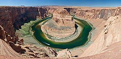
The major rivers of Arizona are the Colorado River, and one of its main tributaries, the Gila River. Nearly all of Arizona is drained by either the Colorado River or one of its tributaries.
The Colorado River is vital to Arizona because of the perennial dryness of the region. The river is famous because of its role in the creation of the Grand Canyon, which was created over a period of six million years. Several irrigation systems divert water from the Colorado River, of which the one most vital to Arizona is the Central Arizona Project. The Central Arizona Project, which is 336 miles (541 km) long, diverts 1,500,000 acre-feet (1.9 km3) of water from Lake Havasu City into central and southern Arizona. [25] The river is also utilized for hydroelectric power through various dams along the river. The dams on the Colorado River, going downstream, are the Glen Canyon Dam, Hoover Dam, Davis Dam, Parker Dam, Imperial Dam, Laguna Dam, and the Morelos Dam.
The Gila River is 650 miles (1,050 km) long, and extends from southwestern New Mexico to its confluence with the Colorado River near Yuma. While the upper Gila River is free-flowing, the portion of the river below the Phoenix area is usually either a trickle or completely dry because of the diversion of water for irrigation. The only major dam on the Gila River is Coolidge Dam, located 31 miles (50 km) southeast of Globe, Arizona.
The Sonoran Desert covers the southwestern area of Arizona, including the cities of Phoenix, Tucson, and Yuma. The Sonoran Desert is one of the hottest deserts of the United States, and maintains warm temperatures year round. Despite the sparse amounts of precipitation during the year, the desert is home to a diverse population of flora and fauna because it has two rainy seasons a year. Several plant populations thrive because of their specialized adaptions to the climate, and various species of cactus can be found in the wild. The Sonoran Desert is the only place in the world where the saguaro cactus grows in the wild, and the fishhook, prickly pear, and organ pipe are among other types of cactus found in the Sonoran Desert.
Northwestern Arizona contains part of the Mojave Desert, which is at a higher altitude than the Sonoran Desert. The boundaries of the Mojave Desert can be determined by the presence of Yucca brevifolia (Yucca palm), which is endemic to the desert. Unlike the Sonoran Desert, the Mojave Desert has few trees, both in number and diversity.
The Painted Desert is a broad area of badlands located on the Colorado Plateau in Northern Arizona. It covers at least 146 square miles (380 km2), and stretches from 30 miles (48 km) north of Cameron, near the Grand Canyon, ending just beyond the Petrified Forest. [26] The Painted Desert derives its name from the multitude of colored sediments and bentonite clay seen from its Chinle rock formation, left exposed by erosion. In the southern portion of the desert, the remains of a Triassic period coniferous forest have fossilized over millions of years. Most of the Painted Desert is located within the Navajo Nation, and is only accessible by foot.
A small portion of southeastern Arizona is part of the Chihuahuan Desert. Because of its higher elevation in comparison to the Sonoran Desert, it tends to have milder temperatures during the summer.
Arizona is the third largest state to not have an ocean coastline—after Montana and New Mexico. Despite being landlocked, Arizona does contain islands, even though the state has the third lowest amount of water at only 363.73 mi² (942 km²) after West Virginia and New Mexico. Arizona's 0.3% of water is the second lowest percentage after New Mexico's 0.2% of water. [27] The majority of Arizona's islands are in the Colorado River (mainly Lake Mead). Lake Roosevelt also contains a number of islands.
Arizona is a fairly mountainous and rugged state, and is home to the world's largest contiguous ponderosa pine forest. Many mountain ranges exceed 9,000 feet (2,700 m) in elevation, and some can hold snow all summer.
Arizona has 194 named mountain ranges. The highest are along the southwest margin of the Colorado Plateau, including the volcanic San Francisco Peaks just north of Flagstaff and the White Mountains of the Mogollon Rim. The Basin and Range region of southern and western Arizona has many rugged ranges existing as sky islands in the Sonoran and Chihuahuan deserts.
Humphreys Peak in the Coconino National Forest is the highest summit in Arizona. It is part of the San Francisco Peaks, a volcanic mountain range 9 miles (14 km) north of Flagstaff. It tops out at 12,633 feet (3,851 m) above sea level, and is one of the most prominent summits in the United States outside of the Rocky Mountains. The mountain is high enough to maintain snow cover in summer, when temperatures may not exceed 40 °F. The only maintained trail to the summit is the Humphreys Trail, a strenuous hike that starts at Arizona Snowbowl. [28] Towards the top of the trail Humphreys Peak contains the only area of subarctic tundra south of the Rocky Mountains[ citation needed ].
Simply referred to as "Agassiz", Agassiz Peak is Mount Humphreys' sister peak and one of the San Francisco Mountains' "Big 4", or the top five highest peaks in Arizona. Its summit is 12,356 feet (3,766 m) above sea level. The mountain is closed to climbers in the summer to protect its fragile tundra environment. This peak loses its snow usually in late May but has been known to keep snow until June. [29]
At 11,946 feet (3,641 m) above sea level, Fremont Peak is also located in the San Francisco Mountains. This summit is relatively unknown to visitors and locals, and it is located along the Doyle Saddle, where it is not very prominent. It really isn't a summit, just a high point on the Doyle Saddle. The Humphreys Trail runs on this ridge and atop Fremont Peak. [30]
Aubineau Peak, the fourth highest summit in Arizona, tops out at 11,818 feet (3,602 m) above sea level. This is a fairly steep peak, and the home of the 2005 avalanche. This mountain is on the north side of the San Francisco Mountains and is adjacent to Abineau Canyon. [31]
Ree's Peak is a much smaller peak than most of the summits in the San Francisco mountains, and at 11,444 feet (3,488 m), it makes the northeastern tip of the range. This peak lacks alpine tundra but is home to the famed bristlecone pine. The peak is distinguishable only by looking directly at it, otherwise the other summits completely flush it out. [31]
Doyle Peak is listed at 11,440 feet (3,487 m), and can be seen as the summit most on the right, if you are looking at the San Francisco Mountains from the Flagstaff area. The peak can be best viewed from Shultz Pass road, and is known for its continuous aspen belt. This peak is the starting point of the Doyle Saddle, connecting Doyle Peak with Agassiz Peak. [32]
Mount Baldy, located in Arizona's White Mountains on the Fort Apache Indian Reservation, is an eroded mountain peak whose summit is 11,391 feet (3,472 m) above sea level. Its name was given to it by locals because it lacks trees on the upper ridge, giving it a baldlike appearance. Mount Baldy is home to the Sunrise Ski Area. The mountain is not part of a range, just a single prominent peak whose flanks are gentle and peak is rounded, not rugged. This is the same for most of the White Mountains, a geologically old range once as high as the Alaska Range, but that has been eroded away over the eons. Mount Baldy is home to a bristlecone pine forest, and some consider the White Mountains as a Rocky Mountains extension due to similar averages in elevation, tree species, animals, and weather.
At 11,348 feet (3,459 m), Mount Ord is part of the White Mountains, and is located in Apache County on the Fort Apache Indian Reservation. Snow often stays on this mountain the longest during summer due to its high elevation and gentle north slope, snow can stick at 3 to 6 inches (76 to 152 mm), sometimes more, until June, only then melting into patches. [33]
At 11,148 feet (3,398 m), Paradise Butte is found in the White Mountains near Mount Baldy and Mount Ord, near Sunrise Ski Park.
In Apache County, Mount Thomas tops out at 11,121 feet (3,390 m).
California is a U.S. state on the western coast of North America. Covering an area of 163,696 sq mi (423,970 km2), California is among the most geographically diverse states. The Sierra Nevada, the fertile farmlands of the Central Valley, and the arid Mojave Desert of the south are some of the major geographic features of this U.S. state. It is home to some of the world's most exceptional trees: the tallest, most massive, and oldest. It is also home to both the highest and lowest points in the 48 contiguous states. The state is generally divided into Northern and Southern California, although the boundary between the two is not well defined. San Francisco is decidedly a Northern California city and Los Angeles likewise a Southern California one, but areas in between do not often share their confidence in geographic identity. The US Geological Survey defines the geographic center of the state at a point near North Fork, California.
The Colorado River is one of the principal rivers in the Southwestern United States and in northern Mexico. The 1,450-mile-long (2,330 km) river, the 5th longest in the United States, drains an expansive, arid watershed that encompasses parts of seven U.S. states and two Mexican states. The name Colorado derives from the Spanish language for "colored reddish" due to its heavy silt load. Starting in the central Rocky Mountains of Colorado, it flows generally southwest across the Colorado Plateau and through the Grand Canyon before reaching Lake Mead on the Arizona–Nevada border, where it turns south toward the international border. After entering Mexico, the Colorado approaches the mostly dry Colorado River Delta at the tip of the Gulf of California between Baja California and Sonora.
The Sonoran Desert is a hot desert in North America and ecoregion that covers the northwestern Mexican states of Sonora, Baja California, and Baja California Sur, as well as part of the southwestern United States. It is the hottest desert in both Mexico and the United States. It has an area of 260,000 square kilometers (100,000 sq mi).
Kaibab National Forest borders both the north and south rims of the Grand Canyon, in north-central Arizona. Its 1.6 million acres is divided into three sections: the North Kaibab Ranger District, the Tusayan Ranger District, and the Williams Ranger District. It is managed by the United States Forest Service. Grand Canyon National Park separates the North Kaibab and the South Kaibab. The South Kaibab covers 1,422 square miles (3,680 km2) and the North Kaibab stretches over 1,010 square miles (2,600 km2). Elevations vary on the forest from 5,500 feet in the southwest corner to 10,418 feet at the summit of Kendrick Peak on the Williams Ranger District. The forest as a whole is headquartered in Williams.
Colorado Desert is a part of the larger Sonoran Desert located in California, United States and Baja California, Mexico. It encompasses approximately 7 million acres, including the heavily irrigated Coachella, Imperial and Mexicali valleys. It is home to many unique flora and fauna.
The San Francisco Peaks are a volcanic mountain range in the San Francisco volcanic field in north central Arizona, just north of Flagstaff and a remnant of the former San Francisco Mountain. The highest summit in the range, Humphreys Peak, is the highest point in the state of Arizona at 12,637 feet (3,852 m) in elevation. The San Francisco Peaks are the remains of an eroded stratovolcano. An aquifer within the caldera supplies much of Flagstaff's water while the mountain itself is in the Coconino National Forest, a popular recreation site. The Arizona Snowbowl ski area is on the western slopes of Humphreys Peak, and has been the subject of major controversy involving several tribes and environmental groups.
Greer is an unincorporated community and census-designated place in Apache County, Arizona, United States. Located within the White Mountains of Arizona and surrounded by the Apache-Sitgreaves National Forest, Greer is the highest town in the state at an elevation of approximately 8,400 feet. As of the 2020 census it had a population of 58. Greer was founded circa 1879 by Mormon settlers from Utah. The Greer post office has the ZIP code of 85927.
The Coconino National Forest is a 1.856-million acre United States National Forest located in northern Arizona in the vicinity of Flagstaff, with elevations ranging from 2,600 feet to the highest point in Arizona at 12,633 feet. Originally established in 1898 as the "San Francisco Mountains National Forest Reserve", the area was designated a U.S. National Forest by Pres. Theodore Roosevelt on July 2, 1908, when the San Francisco Mountains National Forest Reserve was merged with lands from other surrounding forest reserves to create the Coconino National Forest. Today, the Coconino National Forest contains diverse landscapes, including deserts, ponderosa pine forests, flatlands, mesas, alpine tundra, and ancient volcanic peaks. The forest surrounds the towns of Sedona and Flagstaff and borders four other national forests; the Kaibab National Forest to the west and northwest, the Prescott National Forest to the southwest, the Tonto National Forest to the south, and the Apache-Sitgreaves National Forest to the southeast. The forest contains all or parts of nine designated wilderness areas, including the Kachina Peaks Wilderness, which includes the summit of the San Francisco Peaks. The headquarters are in Flagstaff. The Coconino National Forest consists of three districts: Flagstaff Ranger District, Mogollon Rim Ranger District, and Red Rock Ranger District, which have local ranger district offices in Flagstaff, Happy Jack, and Sedona.
The Chocolate Mountains of California are located in Imperial and Riverside counties in the Colorado Desert of Southern California. The mountains stretch more than 60 miles (100 km) in a northwest to southeast direction, and are located east of the Salton Sea and south and west of the Chuckwalla Mountains and the Colorado River. To the northwest lie the Orocopia Mountains.
The Kaibab Plateau is a plateau almost entirely in Coconino County, Arizona in the Southwestern United States. The high plain is also known as the Buckskin Mountain, Buckskin Plateau, and Kaibab Mountain.
The following is an alphabetical list of articles related to the U.S. state of Arizona.
The geography of the U.S. State of Colorado is diverse, encompassing both rugged mountainous terrain, vast plains, desert lands, desert canyons, and mesas. Colorado is a landlocked U.S. state. In 1861, the United States Congress defined the boundaries of the new Territory of Colorado exclusively by lines of latitude and longitude, stretching from 37°N to 41°N latitude, and from 102°02'48"W to 109°02'48"W longitude. Starting in 1868, official surveys demarcated the boundaries, deviating from the parallels and meridians in several places. Later surveys attempted to correct some of these mistakes but in 1925 the U.S. Supreme Court affirmed that the earlier demarcation was the official boundary. The borders of Colorado are now officially defined by 697 boundary markers connected by straight boundary lines. Colorado, Wyoming, and Utah are the only states that have their borders defined solely by straight boundary lines with no natural features. The southwest corner of Colorado is the Four Corners Monument at 36°59'56"N, 109°2'43"W. This is the only place in the United States where four states meet: Colorado, New Mexico, Arizona, and Utah.
The Tushar Mountains are the third-highest mountain range in Utah after the Uinta Mountains and the La Sal Range. Located in the Fishlake National Forest, Delano Peak, 12,174 ft NAVD 88, is the highest point in both Beaver and Piute counties and has a prominence of 4,689 ft. Delano Peak is named for Columbus Delano (1809–1896), Secretary of the Interior, during the Grant administration. The Tushars receive an ample amount of snow annually even though they are situated within the rainshadow of the Sierra Nevada range in California and the Snake Range located in Nevada.
Mount Baldy is an extinct stratovolcano in eastern Arizona in the United States. With a summit elevation of 11,409 feet (3,477 m), the peak of Mount Baldy rises above the tree line and is left largely bare of vegetation, lending the mountain its current name. The Mount Baldy Wilderness occupies the eastern slope of the mountain and is managed by the Apache-Sitgreaves National Forest.
The Lower Colorado River Valley (LCRV) is the river region of the lower Colorado River of the southwestern United States in North America that rises in the Rocky Mountains and has its outlet at the Colorado River Delta in the northern Gulf of California in northwestern Mexico, between the states of Baja California and Sonora. This north–south stretch of the Colorado River forms the border between the U.S. states of California/Arizona and Nevada/Arizona, and between the Mexican states of Baja California/Sonora.
The landlocked U.S. state of Nevada has a varied geography and is almost entirely within the Basin and Range Province and is broken up by many north–south mountain ranges. Most of these ranges have endorheic valleys between them.
With a total area of 121,590 square miles (314,900 km2), New Mexico is the fifth-largest state, after Alaska, Texas, California, and Montana. Its eastern border lies along 103°W longitude with the state of Oklahoma, and 2.2 miles west of 103°W longitude with Texas. On the southern border, Texas makes up the eastern two-thirds, while the Mexican states of Chihuahua and Sonora make up the western third, with Chihuahua making up about 90% of that. The western border with Arizona runs along the 109° 03'W longitude. The southwestern corner of the state is known as the Bootheel. The 37°N parallel forms the northern boundary with Colorado. The states of New Mexico, Colorado, Arizona, and Utah come together at the Four Corners in New Mexico's northwestern corner. Its surface water area is about 292 square miles (760 km2).
The Arizona transition zone is a diagonal northwest-by-southeast region across central Arizona. The region is a transition from the higher-elevation Colorado Plateau in Northeast Arizona and the Basin and Range region of lower-elevation deserts in the southwest and south.
The Mountain states form one of the nine geographic divisions of the United States that are officially recognized by the United States Census Bureau. It is a subregion of the Western United States.