El Salvador is a country in Central America. Situated at the meeting point of three tectonic plates, it is highly seismologically active and the location of numerous earthquakes and volcanic eruptions. The country has a tropical climate.

The Northern Mariana Islands, officially the Commonwealth of the Northern Mariana Islands, is an unincorporated territory and commonwealth of the United States consisting of 14 islands in the northwestern Pacific Ocean. The CNMI includes the 14 northernmost islands in the Mariana Archipelago; the southernmost island, Guam, is a separate U.S. territory. The Northern Mariana Islands were listed by the United Nations as a non-self governing territory until 1990.

Saipan is the largest island and capital of the Northern Mariana Islands, a commonwealth of the United States in the western Pacific Ocean. According to 2020 estimates by the United States Census Bureau, the population of Saipan was 43,385, a decline of 10% from its 2010 count of 48,220.

Haleakalā, or the East Maui Volcano, is a massive, active shield volcano that forms more than 75% of the Hawaiian Island of Maui. The western 25% of the island is formed by another volcano, Mauna Kahalawai, also referred to as the West Maui Mountains.

Farallón de Pájaros, also known as Uracus or Urracas, is a small (2.3 km2) uninhabited volcanic island, the northernmost island and also farthest west in the Northern Mariana Islands chain.
Jeju Island is South Korea's largest island, covering an area of 1,833.2 km2 (707.8 sq mi), which is 1.83% of the total area of the country. Alongside outlying islands, it is part of Jeju Province.

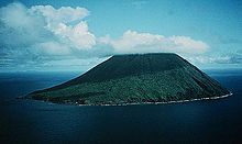
Pagan is a volcanic island in the Marianas archipelago in the northwest Pacific Ocean, under the jurisdiction of the Commonwealth of the Northern Mariana Islands. It lies midway between Alamagan to the south and Agrihan to the north. The island has been largely uninhabited ever since most of its 50 residents were evacuated due to volcanic eruptions in 1981.

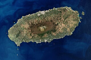
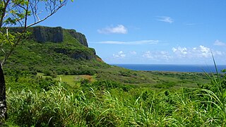
Anatahan is an island in the Northern Mariana Islands in the Pacific Ocean, and has one of the most active volcanoes of the archipelago. Although formerly inhabited, the island is currently uninhabited due to the constant danger of volcanic eruptions. Anatahan is located 60 kilometers (32 nmi) northwest of Farallon de Medinilla and 120 km (65 nmi) north of Saipan. It last erupted between 2007 and 2008, and also erupted in 2003.

Maug consists of a group of three small uninhabited islands. This island group is part of the Northern Islands Municipality of the Commonwealth of the Northern Mariana Islands, itself part of the Marianas archipelago in the Oceanian sub-region of Micronesia.

Asuncion is an island in the Northern Mariana Islands chain in the Pacific Ocean. The island is uninhabited. Asuncion is situated 101 kilometers (63 mi) northwest of Agrihan and 37 km (23 mi) southeast of the Maug Islands.

Alamagan is an island in the Northern Mariana Islands in the Pacific Ocean, 30 kilometres (16 nmi) north of Guguan, 250 kilometres (135 nmi) north of Saipan, and 60 kilometres (32 nmi) south of Pagan. It is currently undergoing resettlement since 2018, with a few people living there. The project was coordinated by the Northern Islands Mayor's office and the people there have radio contact with the mainland.

Agrihan is an island in the Northern Mariana Islands in the Pacific Ocean. The island has mostly been uninhabited, but had 4 permanent residents in the 2020 U.S. census. Agrihan is located 62 kilometers (39 mi) to the north of Pagan.

Sarigan or Sariguan is an uninhabited volcanic island in the Pacific Ocean. It is part of the Northern Mariana Islands, a U.S. territory. Sarigan is located 37 kilometers (20 nmi) northeast of Anatahan island, 67 km (36 nmi) south of Guguan and 150 km (81 nmi) north of Saipan, the largest island in the Northern Marianas. The island has been sparsely populated, but in modern times has been uninhabited due to volcanic activity. It is a currently a nature preserve.
Northern Islands Municipality is one of the four main political divisions of the Commonwealth of the Northern Mariana Islands. It consists of a long string of the northernmost islands of the Northern Marianas, including Farallon de Pajaros, the Maug Islands, Asuncion, Agrihan, Pagan, Alamagan, Guguan, Zealandia Bank, Sarigan, Anatahan, and Farallon de Medinilla. The total land area of the islands, including offshore islets and rocks, is 154.755 km2.
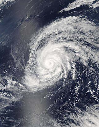
Typhoon Kong-rey was a moderate typhoon that affected Guam and the Northern Mariana Islands in early April 2007. The first named storm of the 2007 Pacific typhoon season, Kong-rey became the earliest-occurring typhoon since Typhoon Sudal in 2004. At its peak, it was considered to be a Category 2-equivalent typhoon by the Joint Typhoon Warning Center, though re-analysis increased it to a Category 3-equivalent. Typhoon Kong-rey caused about $10,000 in damages and no injuries along its path.

Arizona is a landlocked state situated in the southwestern region of the United States of America. It has a vast and diverse geography famous for its deep canyons, high- and low-elevation deserts, numerous natural rock formations, and volcanic mountain ranges. Arizona shares land borders with Utah to the north, the Mexican state of Sonora to the south, New Mexico to the east, and Nevada to the northwest, as well as water borders with California and the Mexican state of Baja California to the southwest along the Colorado River. Arizona is also one of the Four Corners states and is diagonally adjacent to Colorado.
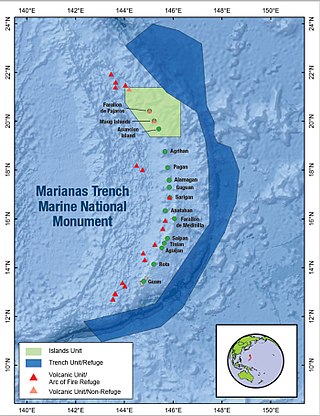
The Marianas Trench Marine National Monument is a United States National Monument created by President George W. Bush by the presidential proclamation no. 8335 on January 6, 2009. The monument includes no dry land area, but protects 95,216 square miles (246,610 km2) of submerged lands and waters in various places in the Mariana Archipelago. The United States could create this monument under international law because the maritime exclusive economic zones of the adjacent Northern Mariana Islands and Guam fall within its jurisdiction.

Typhoon Joan was the longest-lasting super typhoon at the time, maintaining 1-minute maximum sustained winds of at least 240 km/h (150 mph) for 4.5 days. Joan, concurrently with Typhoon Ivan to its west, also became the strongest typhoons at the same time in the northwest Pacific Ocean. The 25th named storm during the hyperactive 1997 Pacific typhoon season, Joan developed from the same trough as Typhoon Ivan on October 11. It moved northwestward and later to the west, undergoing explosive deepening to its peak intensity on October 15. One typhoon warning agency estimated that Joan was among the strongest storms on record in the basin, and that Ivan and Joan marked the first occurrence of simultaneous super typhoons. While near peak intensity, Joan passed between Anatahan and Saipan in the Northern Marianas Islands. Later, the typhoon weakened and turned to the north and east, becoming extratropical on October 24.
The Marianas tropical dry forests is a tropical and subtropical dry broadleaf forests ecoregion on the Marianas Islands in the western Pacific Ocean.

Daikoku Seamount is a submarine volcano located in the Northern Mariana Islands, in the western Pacific Ocean. It is part of a chain of volcanoes and seamounts that includes the more known Ahyi Seamount and NW Rota-1 seamounts and is situated about 690 km (429 mi) north of the island of Saipan. Daikoku Seamount rises over 2,500 m (8,202 ft) meters from the seafloor, with its summit about 323 m (1,060 ft) below sea level. Since its discovery, the seamount has been studied by several expeditions, including expeditions made by NOAA, using various scientific tools, such as sonar mapping and remotely operated vehicles (ROVs). Daikoku Seamount is known for its active hydrothermal vent system, which hosts diverse communities of deep-sea organisms, including tube worms, crabs, and snails. The seamount is also one of the only volcanoes along with Nikkō Seamount to have had a partially molten sulfur lake, which is usually a feature seen on Io than on Earth.