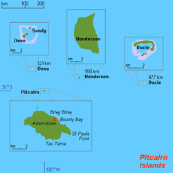
Geography of the Pitcairn Islands

Last updated

Map of Pitcairn Islands. Map of Pitcairn Islands 2.png
Map of Pitcairn Islands.

The Pitcairn Islands are a group of four islands in the south Pacific Ocean: the group comprises Pitcairn Island (a volcanic island), Henderson Island (an uplifted coral island), and two coral atolls, Oeno Island and Ducie Island.

Contents

The only inhabited island, Pitcairn, has an area of 5 km2 (1.9 sq mi) and a population density of 10/km2 (26/sq mi); it is only accessible by boat through Bounty Bay. The other islands are at a distance of more than 100 km (62 mi).

Location

Pitcairn postage stamp, c.1940, with helpful map. Stamp pitcairn islands 3d.jpg
Pitcairn postage stamp, c.1940, with helpful map.

The Pitcairn Islands as a group of islands in Oceania:( 25°04′00″S130°05′00″W / 25.06667°S 130.08333°W / -25.06667; -130.08333 )

Situated in the South Pacific Ocean, about one-half of the way from Peru to New Zealand, they are one of the most remote sites of human habitation on Earth. [1] [2]

The only inhabited island, Pitcairn, is at 25.04 south, 130.06 west. Pitcairn is about 2,170 kilometres (1,350 mi) southeast of Tahiti, 5,310 kilometres (3,300 mi) from Auckland, New Zealand, and over 6,600 kilometres (4,100 mi) from Panama. [3]

Area

Enlargeable, detailed map of Pitcairn Island Pitcairn2021OSM.png
Enlargeable, detailed map of Pitcairn Island
Total:47 km2 (18 sq mi)
Land:47 km2 (18 sq mi)
Water:0 km2 (0 sq mi)

Pitcairn Island is about 3.2 kilometres (2.0 mi) long and 1.6 kilometres (0.99 mi) wide. [3] This is about 310 of the size of Washington, DC.

Land boundaries

0 km (0 mi)

Coastline

51 km (32 mi)

Maritime claims

Exclusive economic zone:836,000 km2 (323,000 sq mi)
Territorial sea:3 nautical miles (5.6 km; 3.5 mi)

Climate

The Pitcairn Islands have a maritime tropical rainforest climate (Af according to the Köppen climate classification), with the climate being warm and humid year-round, with no dry season. The warmest month in Adamstown is February, with a mean of 23.8 °C (74.8 °F), while the coolest month is August, with a mean of 18.5 °C (65.3 °F). The highest temperature recorded was 33.3 °C (91.9 °F) during March. Because of its maritime location, the temperature has never dropped below 10 °C (50 °F). Adamstown receives 1,543 millimetres (60.7 in) of rainfall annually, with the rain being evenly distributed across the year. The climate of the Pitcairn Islands is modified by southeast trade winds.

Climate data for Pitcairn Island (1972-2004)
MonthJanFebMarAprMayJunJulAugSepOctNovDecYear
Record high °C (°F)31.2
(88.2)
32.4
(90.3)
33.3
(91.9)
30.7
(87.3)
29.1
(84.4)
31.3
(88.3)
26.7
(80.1)
26.7
(80.1)
25.5
(77.9)
27.8
(82.0)
27.6
(81.7)
29.3
(84.7)
33.3
(91.9)
Average high °C (°F)25.7
(78.3)
26.2
(79.2)
26.1
(79.0)
24.6
(76.3)
22.9
(73.2)
21.7
(71.1)
20.8
(69.4)
20.6
(69.1)
21.0
(69.8)
21.8
(71.2)
22.9
(73.2)
24.2
(75.6)
23.2
(73.8)
Daily mean °C (°F)23.3
(73.9)
23.8
(74.8)
23.8
(74.8)
22.5
(72.5)
20.9
(69.6)
19.7
(67.5)
18.8
(65.8)
18.5
(65.3)
18.8
(65.8)
19.6
(67.3)
20.7
(69.3)
22.0
(71.6)
21.0
(69.9)
Average low °C (°F)21.0
(69.8)
21.4
(70.5)
21.5
(70.7)
20.3
(68.5)
18.9
(66.0)
17.8
(64.0)
16.9
(62.4)
16.5
(61.7)
16.6
(61.9)
17.4
(63.3)
18.6
(65.5)
19.8
(67.6)
18.9
(66.0)
Record low °C (°F)16.9
(62.4)
18.0
(64.4)
12.8
(55.0)
15.0
(59.0)
14.2
(57.6)
11.7
(53.1)
11.4
(52.5)
11.6
(52.9)
10.0
(50.0)
10.2
(50.4)
13.0
(55.4)
13.5
(56.3)
10.0
(50.0)
Average precipitation mm (inches)96.5
(3.80)
132.7
(5.22)
107.8
(4.24)
114.8
(4.52)
111.9
(4.41)
152.8
(6.02)
139.0
(5.47)
131.6
(5.18)
134.5
(5.30)
143.0
(5.63)
120.4
(4.74)
157.7
(6.21)
1,542.7
(60.74)
Source 1: NOAA [4]
Source 2: KNMI (precipitation) [5]


Terrain

Geodesy Collection on Pitcairn Island Geodesy Collection Pitcairn Island.jpg
Geodesy Collection on Pitcairn Island

The Pitcairn Islands have a rugged terrain caused by volcanic formation, with a rocky coastline and cliffs.

Elevation extremes

Lowest point: Pacific Ocean coastline 0 m (sea level)
Highest point: Pawala Valley Ridge 347 m (1,138 ft)

Natural resources

Miro trees (used for handicrafts), fish
Note: manganese, iron, copper, gold, silver, and zinc have been discovered offshore

Natural hazards

Tropical Cyclones (especially November to May)

Environment – current issues

Deforestation (only a small portion of the original forest remains because of burning and clearing for settlement)

Maps

Map all coordinates using: OpenStreetMap

Worldwide map services show very little detail of the islands, and are even of limited use to show the location of them with respect to each other and to other islands, because they are so small and far apart. However, Mapquest zoom level 1 is a suitable map to see the location between Peru and New Zealand.

For the location with respect to French Polynesia, see the inset of Image:French Polynesia map.jpg.

See also

Related Research Articles

<span class="mw-page-title-main">Geography of the British Virgin Islands</span> Part of island group of the Caribbean Lesser Antilles

The British Virgin Islands (BVI) are one of three political divisions of the Virgin Islands archipelago located in the Lesser Antilles, between the Caribbean Sea and the North Atlantic Ocean. The BVI are the easternmost part of the island chain. The land area totals and comprises 16 inhabited and more than 20 uninhabited islands. The islands of Tortola, Anegada, Virgin Gorda and Jost van Dyke are the largest. Maritime claims include 12 nmi territorial sea and a 200 nmi exclusive fishing zone. In terms of land use, it is 20% arable land, 6.67% permanent crops and 73.33% other as of a 2005 figure. It has strong ties to nearby U.S. Virgin Islands and Puerto Rico.

<span class="mw-page-title-main">Geography of Macau</span> Geography of the special region in China

Macau is a Special Administrative Region on the southern coast of China. It is located at the south of Guangdong Province, on the tip of the peninsula formed by the Zhujiang estuary on the east and the Xijiang on the west. Macau is situated 60 km (37 mi) west of Hong Kong, and 145 km (90 mi) southwest of Guangzhou, the capital of Guangdong Province. It is situated immediately east and south of Zhuhai.

<span class="mw-page-title-main">Pacific Ocean</span> Ocean between Asia, Oceania, and the Americas

The Pacific Ocean is the largest and deepest of Earth's five oceanic divisions. It extends from the Arctic Ocean in the north to the Southern Ocean in the south, and is bounded by the continents of Asia and Oceania in the west and the Americas in the east.

<span class="mw-page-title-main">Pitcairn Islands</span> British overseas territory in the South Pacific

The Pitcairn Islands, officially the Pitcairn, Henderson, Ducie and Oeno Islands, are a group of four volcanic islands in the southern Pacific Ocean that form the sole British Overseas Territory in the Pacific Ocean. The four islands—Pitcairn, Henderson, Ducie and Oeno—are scattered across several hundred miles of ocean and have a combined land area of about 18 square miles (47 km2). Henderson Island accounts for 86% of the land area, but only Pitcairn Island is inhabited. The islands nearest to the Pitcairn Islands are Mangareva at 688 km to the west and Easter Island at 1,929 km to the east.

<span class="mw-page-title-main">Geography of Tonga</span>

Located in Oceania, Tonga is a small archipelago in the South Pacific Ocean, directly south of Samoa and about two-thirds of the way from Hawaii to New Zealand. It has 169 islands, 36 of them inhabited, which are in three main groups – Vavaʻu, Haʻapai, and Tongatapu – and cover an 800-kilometre (500-mile)-long north–south line. The total size is just 747 km2 (288 sq mi). Due to the spread out islands it has the 40th largest Exclusive Economic Zone of 659,558 km2 (254,657 sq mi).

<span class="mw-page-title-main">Atoll</span> Ring-shaped coral reef

An atoll is a ring-shaped island, including a coral rim that encircles a lagoon. There may be coral islands or cays on the rim. Atolls are located in warm tropical or subtropical parts of the oceans and seas where corals can develop. Most of the approximately 440 atolls in the world are in the Pacific Ocean.

<span class="mw-page-title-main">Geography of Fiji</span>

Fiji is a group of volcanic islands in the South Pacific, lying about 4,450 kilometres (2,765 mi) southwest of Honolulu and 1,770 km (1,100 mi) north of New Zealand. Of the 332 islands and 522 smaller islets making up the archipelago, about 106 are permanently inhabited. The total land size is 18,272 km2 (7,055 sq mi). It has the 26th largest Exclusive Economic Zone of 1,282,978 km2 (495,361 sq mi).

<span class="mw-page-title-main">Geography of Seychelles</span> Geography of the Seychelles islands

Seychelles is a small island country east of the African continent's mainland located in the Sea of Zanj due north of Madagascar, with Antsiranana as its nearest foreign city. Seychelles lies between approximately 4ºS and 10ºS and 46ºE and 54ºE. The nation is an archipelago of 155 tropical islands, some granite and some coral. the majority of which are small and uninhabited. The landmass is only 452 km2 (175 sq mi), but the islands are spread wide over an exclusive economic zone of 1,336,559 km2 (516,048 sq mi). About 90 percent of the population of 100,000 live on Mahé, 9 percent on Praslin and La Digue. Around a third of the land area is the island of Mahé and a further third the atoll of Aldabra.

<span class="mw-page-title-main">Geography of Iceland</span> Geographical features of Iceland

Iceland is an island country at the confluence of the North Atlantic and Arctic oceans, east of Greenland and immediately south of the Arctic Circle, atop the constructive boundary of the northern Mid-Atlantic Ridge. The island country is the world's 18th largest in area and one of the most sparsely populated. It is the westernmost European country when not including Greenland and has more land covered by glaciers than continental Europe. Its total size is 103,125 km2 (39,817 sq mi) and possesses an exclusive economic zone of 751,345 km2 (290,096 sq mi).

<span class="mw-page-title-main">Geography of France</span> Overview of the geography of France

The geography of France consists of a terrain that is mostly flat plains or gently rolling hills in the north and west and mountainous in the south and the east. Metropolitan France has a total size of 551,695 km2 (213,011 sq mi). It is the third largest country in Europe by area and the largest in Western Europe.

<span class="mw-page-title-main">Geography of Barbados</span> Geography of Barbados

Barbados is a continental island in the North Atlantic Ocean and is located at 13°10' north of the equator, and 59°32' west of the Prime Meridian. As the easternmost isle of the Lesser Antilles in the West Indies, Barbados lies 160 kilometres (100 mi) east of the Windward Islands and Caribbean Sea. The maritime claim for Barbados is a territorial sea of 12 nmi, with an exclusive economic zone of 200 nmi which gives Barbados a total maritime area of 186,898 km2 (72,162 sq mi). Of the total EEZ area, 70,000 km2 is set aside for offshore oil exploration. A pending application to UNCLOS has placed for consideration a continental shelf 200 nmi to the east and south. To the west, most of Barbados' maritime boundaries consist of median lines with neighbours. These neighbours include: Martinique, and Saint Lucia to the northwest, Saint Vincent and the Grenadines to the west, Trinidad and Tobago and Venezuela to the southwest, and Guyana to the southeast.

<span class="mw-page-title-main">History of the Pitcairn Islands</span> Chronology of the Pitcairn Islands

The history of the Pitcairn Islands begins with the colonization of the islands by Polynesians in the 11th century. Polynesian people established a culture that flourished for four centuries and then vanished. They lived on Pitcairn and Henderson Islands, and on Mangareva Island 540 kilometres (340 mi) to the northwest, for about 400 years.

<span class="mw-page-title-main">Oeno Island</span> Atoll in the Pitcairn Islands, British Overseas Territories

Oeno Island or Holiday Island is an uninhabited coral atoll in the South Pacific Ocean, part of the Pitcairn Islands overseas territory. It is part of the Pitcairn Island Group, together with Pitcairn, Henderson and Ducie islands.

<span class="mw-page-title-main">Henderson Island (Pitcairn Islands)</span> Largest of the Pitcairn Islands, British Overseas Territories

Henderson Island is an uninhabited island in the south Pacific Ocean. It is part of the Pitcairn Island Group, together with Pitcairn, Oeno, and Ducie Islands. Measuring 9.6 by 5.1 kilometres, it has an area of 37.3 km2 (14.4 sq mi) and is located 193 km (104 nmi) northeast of Pitcairn Island, which is the only inhabited island of the group. It has poor soil and little fresh water, and is unsuitable for agriculture. There are three beaches on the northern end and the remaining coast comprises steep cliffs up to 15 m (50 ft) in height. In 1902, it was annexed to the Pitcairn Islands colony, which is now a British Overseas Territory.

<span class="mw-page-title-main">Ducie Island</span> Atoll in the Pitcairn Islands, British Overseas Territories

Ducie Island is an uninhabited atoll in the Pitcairn Islands group, which also includes Pitcairn, Henderson and Oeno islands. Ducie lies east of Pitcairn Island, and east of Henderson Island, and has a total area of 1.5 square miles (3.9 km2), which includes the lagoon. It is 1.5 miles (2.4 km) long, measured northeast to southwest, and about 1 mile (1.6 km) wide. The island is composed of four islets: Acadia, Pandora, Westward and Edwards.

<span class="mw-page-title-main">Pitcairn hotspot</span>

The Pitcairn hotspot is a volcanic hotspot located in the south-central Pacific Ocean. Over the past 11 million years, it has formed the Pitcairn-Gambier hotspot chain. It is responsible for creating the Pitcairn Islands and two large seamounts named Adams and Bounty, as well as atolls at Moruroa, Fangataufa and the Gambier Islands. The hotspot is currently located at Adams and Bounty, which are ~60 kilometers East-Southeast of Pitcairn Island.

<span class="mw-page-title-main">Geography of Antigua and Barbuda</span>

Antigua and Barbuda lie in the eastern arc of the Leeward Islands of the Lesser Antilles, separating the Atlantic Ocean from the Caribbean Sea. Antigua is 650 km (400 mi) southeast of Puerto Rico; Barbuda lies 48 km (30 mi) due north of Antigua, and the uninhabited island of Redonda is 56 km (35 mi) southwest of Antigua.

The Nullica River is an intermittently closed semi-mature saline coastal lagoon or perennial river, located in the South Coast region of New South Wales, Australia.

Same-sex marriage has been legal in the Pitcairn Islands since 14 May 2015. An ordinance to permit same-sex marriages was passed unanimously by the Island Council on 1 April 2015, and received royal assent by Governor Jonathan Sinclair on 5 May.

Crough Seamount is a seamount in the Pacific Ocean, within the exclusive economic zone of Pitcairn. It rises to a depth of 650 metres (2,130 ft) and is paired with a taller but overall smaller seamount to the east. This seamount has a flat top and probably formed an island in the past. It is about 7-8 million years old, although a large earthquake recorded at its position in 1955 may indicate a recent eruption.

References

  1. Shadle, Robert (1996). Historical Dictionary of the British Empire. Greenwood Publishing Group. p. 890. ISBN   978-0-313-29367-2 . Retrieved 31 October 2011.
  2. Ntumy, Michael A. (1993). South Pacific islands legal systems. University of Hawaii Press. p. 252. ISBN   978-0-8248-1438-0 . Retrieved 31 October 2011.
  3. 1 2 "Official website". The Government of the Pitcairn Islands. Retrieved 12 August 2021.
  4. "PITCAIRN ISLAND C, PC". National Oceanic and Atmospheric Administration . Retrieved January 5, 2023.
  5. "Time series: monthly PITCAIRN IS. (UK) GHCN v2 precipitation (all)". Royal Netherlands Meteorological Institute . Retrieved January 5, 2023.

Gnome-globe.svg Wikimedia Atlas of the Pitcairn Islands