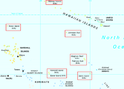
United States Minor Outlying Islands

Last updated

United States Minor Outlying Islands
Flag of the United States (DoS ECA Color Standard).svg
Flag
Motto: 
Anthem: "The Star-Spangled Banner"
United States Minor Outlying Islands.png
Locations of the United States Minor Outlying Islands in the Pacific Ocean; Navassa Island is not located on this map.
Administrative center Washington, D.C., U.S.
Largest village Wake Island
National language English
Government
  President
Joe Biden (D)
Area
 Total
49.26 km2 (19.02 sq mi)(Unranked)
 Water (%)
88.6
Population
 2009 estimate
300(232nd)
 2000 census
316
GDP  (PPP)estimate
 Per capita
$46,381a(6th)
Currency United States dollar (US$) (USD)
Time zone UTC −12 to −10, −5, +12
ISO 3166 code UM
Internet TLD .us b
  1. 2000 estimate.
  2. .um was retired in 2007.
Brown boobies atop pier posts at Johnston Atoll, September 2005 Brown boobies atop pier posts at Johnston Atoll NWR.jpg
Brown boobies atop pier posts at Johnston Atoll, September 2005

The United States Minor Outlying Islands is a statistical designation defined by the International Organization for Standardization's ISO 3166-1 code. The entry code is ISO 3166-2:UM. The minor outlying islands and groups of islands consist of eight United States insular areas in the Pacific Ocean (Baker Island, Howland Island, Jarvis Island, Johnston Atoll, Kingman Reef, Midway Atoll, Palmyra Atoll, and Wake Island) and one in the Caribbean Sea (Navassa Island).

Contents

The islands, though scattered across the Pacific and quite small, are rich in history and nature, and have been quite strategically important. The nearly barren Howland is famous for being the island Amelia Earhart, a famous American woman that vanished on her round the world flight in 1937, was going to land on. Wake, home to a now extinct flightless bird, was the site of a pitched WW2 battle in 1941, and was an important stopover for aircraft transiting the Pacific in the mid-20th century. Likewise, Midway Atoll is home to many corals and birds, and was also the center of a famous battle of WW2 which helped turn the tide of the Pacific war. Other islands, like Palmyra, are rich in unique biodiversity and was also the site of a WW2 base. Johnston Atoll was a famous island for its Cold War base, when it was expanded and used to destroy chemical weapon stockpiles; it was also the site of a nuclear accident. Johnston was heavily modified with land expansion, while others are nearly untouched nature reserves.

History

In 1936, a colonization program began to settle Americans on Baker, Howland, and Jarvis, but all three islands were evacuated in 1942 as a result of World War II. [1] [2]

ISO introduced the term "United States Minor Outlying Islands" in 1986. From 1974 until 1986, five of the islands (Baker Island, Howland Island, Jarvis Island, Palmyra Atoll, and Kingman Reef) were grouped under the term United States Miscellaneous Pacific Islands, with ISO 3166 code PU. The code of Midway Atoll was MI, the code of Johnston Atoll was JT, and the code of Wake Island was WK. Prior to 1986, Navassa Island, along with several small islands in the Caribbean Sea that are no longer under U.S. sovereignty, were grouped under the term United States Miscellaneous Caribbean Islands, with FIPS country code BQ.

The populated Stewart Islands, called Sikaiana and now effectively controlled by the Solomon Islands, are not included in official lists of U.S. Minor Outlying Islands. In 1856, the Kingdom of Hawaii Privy Council and King Kamehameha IV voted to accept their voluntary cession. The Kingdom later became the Republic of Hawaii, all of which was annexed by the United States in 1898. In 1959, the resulting federal U.S. Territory of Hawaii, excluding only Palmyra Atoll and Midway Atoll, became a U.S. state. Residents of the Stewart Islands, who are Polynesian like the native Hawaiians rather than Melanesian, claimed to be citizens of the United States since the Stewart Islands were given to King Kamehameha IV in 1856 and were part of Hawaii at the time of the United States' annexation in 1898. The U.S. federal and Hawaii state governments informally accept the recent claim of the Solomon Islands over the Stewart Islands, and the United States makes no official claim of sovereignty. [3]

Overview

Visitor map for Palmyra Atoll Palmyra Atoll Visitor Access Map.jpg
Visitor map for Palmyra Atoll

Except for Palmyra Atoll, all of these islands are unincorporated unorganized territories of the United States. Currently, none of the islands have any known permanent residents, although military personnel, U.S. Fish and Wildlife Service personnel, and temporarily stationed scientific and research staff are posted to some of the islands. The 2000 census counted 315 people on Johnston Atoll and 1 person on Wake Island. [4] The Territory of Palmyra Atoll is an incorporated territory, separated in 1959 from the rest of the former incorporated Territory of Hawaii when Hawaii became a state.

There has been no recorded modern indigenous population, except at the 1940 census. During the late 2010s, the U.S. military began reinvesting in the airfield and other assets on Wake Island. [5]

The islands are grouped together as a statistical convenience. They are not administered collectively, nor do they share a single cultural or political history beyond being uninhabited islands under the sovereignty of the United States. They are all outside of the customs territory of the United States and have no customs duties. [6] Except for Midway Atoll, the Pacific islands are surrounded by large exclusive economic zones and are within the bounds of the Pacific Remote Islands Marine National Monument.

They are collectively represented by the ISO 3166-1 alpha-2 code UM. The individual islands have ISO 3166-2 numerical codes.
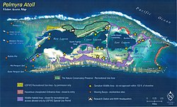
The Internet country code top-level domain (ccTLD) ".um" has historically been assigned to the islands; however, the .um ccTLD was retired in January 2007. [7]

Most of the islands in the U.S. Minor Outlying Islands are closed to the public. Visitors to islands such as Jarvis Island need a permit. Palmyra Atoll is open to the public, but there is no easy way to reach it. [8] [9] [10] [11] [12] [13] [14] [15]

Transportation

Howland island Howland island nasa.jpg
Howland island

Airports

Airports in the United States Minor Outlying Islands provide critical emergency landing points across the vast Pacific Ocean for all types of aircraft, allow for important military presence in key strategic zones, and have limited scheduled commercial services. The following is a list of island airports with ICAO (IATA) codes:

Other airports include:

Seaports

Three of the islands are listed with ports in the World Port Index, [19] with World Port Number:

Baker Island, Howland Island, and Jarvis Island each have a small boat landing place. Kingman Reef and Navassa Island have offshore anchorage only.

Islands and atolls

Atoll or island Island
area
(km2)
Lagoon
(km2)
Coordinates NWR
established
AcquiredFIPS
Code [upper-alpha 1]
GEC [upper-alpha 2] [22]
North Pacific Ocean, Northwestern Hawaiian Islands
Midway Atoll 6.2 [23] 40 28°13′N177°22′W / 28.217°N 177.367°W / 28.217; -177.367 (Midway Atoll) 1988 Apr 22 [24] 1867 Aug 2874300MQ
North Pacific Ocean, scattered isolated islands
Wake Island [upper-alpha 3] 6.5 [25] 6 19°18′N166°38′E / 19.300°N 166.633°E / 19.300; 166.633 (Wake Island) 2009 Jan 16 [26] [27] 1899 Jan 1774450WQ
Johnston Atoll 2.6 [23] 130 16°45′N169°31′W / 16.750°N 169.517°W / 16.750; -169.517 (Johnston Atoll) 1926 Jun 29 [28] 1859 Sep 674200JQ
North Pacific Ocean, Northern Line Islands
Kingman Reef 0.01 [23] 76 6°24′N162°24′W / 6.400°N 162.400°W / 6.400; -162.400 (Kingman Reef) 2001 Jan 18 [29] 1860 Feb 874250KQ
Palmyra Atoll [upper-alpha 4] 3.9 [23] 15 5°53′N162°05′W / 5.883°N 162.083°W / 5.883; -162.083 (Palmyra Atoll) 2001 Jan 18 [30] 1912 Feb 2174400LQ
North Pacific Ocean, Northern Phoenix Islands
Howland Island 2.6 [23] 0°48′N176°37′W / 0.800°N 176.617°W / 0.800; -176.617 (Howland Island) 1974 Jun 27 [1] 1856 Oct 2874100HQ
Baker Island 2.1 [23] 0°12′N176°29′W / 0.200°N 176.483°W / 0.200; -176.483 (Baker Island) 1974 Jun 27 [1] 1856 Oct 2874050FQ
South Pacific Ocean, Central Line Islands
Jarvis Island 5.0 [23] 0°22′S160°01′W / 0.367°S 160.017°W / -0.367; -160.017 (Jarvis Island) 1974 Jun 27 [2] 1856 Oct 2874150DQ
Caribbean Sea, Greater Antilles
Navassa Island [upper-alpha 5] 5.4 [31] 18°24′N75°01′W / 18.400°N 75.017°W / 18.400; -75.017 (Navassa Island) 1999 Dec 3 [32] 1858 Oct 3174350BQ
Caribbean Sea, scattered isolated islets
Bajo Nuevo Bank [upper-alpha 6] 0.02155 15°53′N78°38′W / 15.883°N 78.633°W / 15.883; -78.633 (Bajo Nuevo Bank) 1869 Nov 22(none)(none)
Serranilla Bank [upper-alpha 7] 0.021200 15°50′N79°50′W / 15.833°N 79.833°W / 15.833; -79.833 (Serranilla Bank) 1879 Sep 8
1880 Sep 13
(none)(none)
U.S. Minor Outlying Islands34.3267
  1. Each island (except for Bajo Nuevo Bank and Serranilla Bank) has a unique FIPS (INCITS) code treating it as a county-equivalent for statistical purposes; "74" is the state-level code for the U.S. Minor Outlying Islands. [20] [21]
  2. GEC stands for "Geopolitical Entities and Codes", a coding system superseding the FIPS 10-4 codes; the codes (such as FQ for Baker Island) treat each island as if it were a country. [22]
  3. Claimed by the Marshall Islands.
  4. Previously claimed by Hawaii when independent. Palmyra Atoll was officially a part of the Hawaii Territory until 1959, when Hawaii became a U.S. state.
  5. Claimed by Haiti.
  6. Administered by Colombia, also claimed by Jamaica, not included in the ISO list of territories; its area is not included in the total.
  7. Administered by Colombia, also claimed by Honduras and Jamaica, not included in the ISO list of territories; its area is not included in the total.

Flora and fauna

See also

Related Research Articles

<span class="mw-page-title-main">Baker Island</span> Uninhabited Pacific atoll administered by the United States

Baker Island, formerly known as New Nantucket, is an uninhabited atoll just north of the Equator in the central Pacific Ocean about 3,090 km (1,920 mi) southwest of Honolulu. The island lies almost halfway between Hawaii and Australia. Its nearest neighbor is Howland Island, 42 mi (68 km) to the north-northwest; both have been claimed as territories of the United States since 1857, though the United Kingdom considered them part of the British Empire between 1897 and 1936.

<span class="mw-page-title-main">Jarvis Island</span> Coral island in the South Pacific Ocean

Jarvis Island is an uninhabited 4.5 km2 (1.7 sq mi) coral island located in the South Pacific Ocean, about halfway between Hawaii and the Cook Islands. It is an unincorporated, unorganized territory of the United States, administered by the United States Fish and Wildlife Service of the United States Department of the Interior as part of the National Wildlife Refuge system. Unlike most coral atolls, the lagoon on Jarvis is wholly dry.

<span class="mw-page-title-main">Kingman Reef</span> Reef and unincorporated U.S. territory in the Pacific Ocean

Kingman Reef is a largely submerged, uninhabited, triangle-shaped reef, geologically an atoll, 9.0 nmi (20 km) east-west and 4.5 nmi (8 km) north-south, in the North Pacific Ocean, roughly halfway between the Hawaiian Islands and American Samoa. It has an area of 3 hectares and is a unincorporated territory of the United States in Oceania. The reef is administered by the United States Fish and Wildlife Service as the Kingman Reef National Wildlife Refuge. It was claimed by the US in 1859, and later used briefly as stopover for commercial Pacific flying boat routes in the 1930s going to New Zealand, however the route was changed with a different stopover. It was administered by the Navy from 1934 to 2000, and thereafter the Fish and Wildlife service. It has since become a marine protected area. In the 19th century it was noted as maritime hazard, earning the name Hazard Rocks, and is known to have been hit once in 1876. In the 21st century it has been noted for is marine biodiversity and remote nature. There are hundreds of species of fish and coral on and around the reef.

<span class="mw-page-title-main">Midway Atoll</span> North Pacific Atoll of the United States Minor Outlying Islands

Midway Atoll is a 2.4 sq mi (6.2 km2) atoll in the North Pacific Ocean. Midway Atoll is an insular area of the United States and is an unorganized and unincorporated territory. The largest island is Sand Island, which has housing and an airstrip. Immediately to the east of Sand Island across the narrow Brooks Channel is Eastern Island, which is uninhabited and no longer has any facilities. Forming a rough, incomplete circle around the two main islands and creating Midway Lagoon is Spit Island, a narrow reef.

<span class="mw-page-title-main">Palmyra Atoll</span> Pacific atoll and unorganized incorporated U.S. territory

Palmyra Atoll, also referred to as Palmyra Island, is one of the Northern Line Islands. It is located almost due south of the Hawaiian Islands, roughly one-third of the way between Hawaii and American Samoa. North America is about 3,300 miles northeast and New Zealand the same distance southwest, placing the atoll at the approximate center of the Pacific Ocean. The land area is 4.6 sq mi (12 km2), with about 9 miles (14 km) of sea-facing coastline and reef. There is one boat anchorage, known as West Lagoon, accessible from the sea by a narrow artificial channel and an old airstrip; during WW2 it was turned into Naval Air Station for several years and used for training and refueling. It was shelled by a submarine in December 1941, but was not the site of a major battle.

<span class="mw-page-title-main">Lists of hospitals in the United States</span>

This article contains links to lists of hospitals in the United States, including U.S. States, the national capital of Washington, D.C., insular areas, and outlying islands. Links to more detailed state lists are shown.

In 45 of the 50 states of the United States, the county is used for the level of local government immediately below the state itself. Louisiana uses parishes, and Alaska uses boroughs. In Connecticut, Massachusetts, and Rhode Island, some or all counties within states have no governments of their own; the counties continue to exist as legal entities, however, and are used by states for some administrative functions and by the United States Census bureau for statistical analysis. There are 3,242 counties and county equivalent administrative units in total, including the District of Columbia and 100 county-equivalents in the U.S. territories.

<span class="mw-page-title-main">Insular area</span> U.S. territory that is neither a U.S. state nor the District of Columbia

In the law of the United States, an insular area is a U.S.-associated jurisdiction that is not part of the several states or the District of Columbia.

<span class="mw-page-title-main">Territories of the United States</span>

Territories of the United States are sub-national administrative divisions overseen by the federal government of the United States. The various American territories differ from the U.S. states and Indian reservations as they are not sovereign entities. In contrast, each state has a sovereignty separate from that of the federal government and each federally recognized Native American tribe possesses limited tribal sovereignty as a "dependent sovereign nation." Territories are classified by incorporation and whether they have an "organized" government through an organic act passed by the Congress. American territories are under American sovereignty and, consequently, may be treated as part of the United States proper in some ways and not others. Unincorporated territories in particular are not considered to be integral parts of the United States, and the Constitution of the United States applies only partially in those territories.

<span class="mw-page-title-main">Guano Islands Act</span> Congressional act of the United States

The Guano Islands Act is a United States federal law passed by the Congress that enables citizens of the United States to take possession in the name of the United States of unclaimed islands containing guano deposits. The islands can be located anywhere, so long as they are not occupied by citizens of another country and not within the jurisdiction of another government. It also empowers the president to use the military to protect such interests and establishes the criminal jurisdiction of the United States in these territories.

<span class="mw-page-title-main">Pacific coast</span> Part of a nations coast bordering the Pacific Ocean

Pacific coast may be used to reference any coastline that borders the Pacific Ocean.

An Island Commander is an official who is put in charge of an island, or an insular entity called after an island or an archipelago called Islands.

<span class="mw-page-title-main">Pacific Remote Islands Marine National Monument</span> Group of unorganized United States Pacific Island territories

The Pacific Remote Islands Marine National Monument is a group of unorganized, mostly unincorporated United States Pacific Island territories managed by the United States Fish and Wildlife Service of the United States Department of the Interior and the National Oceanic and Atmospheric Administration (NOAA) of the United States Department of Commerce. These remote refuges are "the most widespread collection of marine- and terrestrial-life protected areas on the planet under a single country's jurisdiction". They protect many endemic species including corals, fish, shellfish, marine mammals, seabirds, water birds, land birds, insects, and vegetation not found elsewhere.

<span class="mw-page-title-main">Howland and Baker Islands</span> Unincorporated U.S. territory

Howland Island and Baker Island are two uninhabited U.S. atolls in the Equatorial Pacific that are located close to one another. Both islands are wildlife refuges, the larger of which is Howland Island. They are both part of the larger political territory of the United States Minor Outlying Islands and they are also both part of the larger geographic grouping of the Phoenix Islands. Each is a National Wildlife Refuge managed by a division of Interior, the U.S. Fish and Wildlife Service. On January 6, 2009, U.S. President George W. Bush included both islands to the Pacific Remote Islands Marine National Monument.

<span class="mw-page-title-main">Outline of Oceania</span> Overview of and topical guide to Oceania

The following outline is provided as an overview and topical guide to Oceania.

References

  1. 1 2 3 "Office of Insular Affairs: Baker and Howland Islands". United States Department of the Interior. Archived from the original on 15 March 2015. Retrieved 3 March 2015.
  2. 1 2 "Office of Insular Affairs: Jarvis Island". United States Department of the Interior. Archived from the original on 2 February 2015. Retrieved 3 March 2015.
  3. "GAO/OGC-98-5 – U.S. Insular Areas: Application of the U.S. Constitution". U.S. Government Printing Office. 7 November 1997. Archived from the original on 27 September 2013. Retrieved 23 March 2013.
  4. US Census 2000 Population Summary Archived 3 December 2017 at the Wayback Machine — see Table I
  5. "The US Military Is Pouring Hundreds Of Millions Of Dollars Into Tiny Wake Island". Honolulu, Hawaiʻi: KITV-TV. 19 October 2019. Archived from the original on 18 November 2021. Retrieved 24 August 2021.
  6. 19 CFR 101.1
  7. Jesdanun, Anick (24 January 2007). "Unused Domain Name for U.S. Isles Gone". NBC News. Archived from the original on 2 April 2015. Retrieved 28 September 2007.
  8. "Midway Atoll NWR - Midway Atoll National Wildlife Refuge and Battle of Midway National Memorial - U.S. Fish and Wildlife Service". www.fws.gov. Archived from the original on 10 June 2016. Retrieved 19 August 2018.
  9. "About the Refuge - Johnston Atoll - U.S. Fish and Wildlife Service". www.fws.gov. Archived from the original on 26 January 2022. Retrieved 19 August 2018.
  10. "About the Refuge - Baker Island - U.S. Fish and Wildlife Service". www.fws.gov. Archived from the original on 14 August 2021. Retrieved 19 August 2018.
  11. "About the Refuge - Howland Island - U.S. Fish and Wildlife Service". www.fws.gov. Archived from the original on 2 November 2021. Retrieved 19 August 2018.
  12. "Rare tour to Wake Island". www.intltravelnews.com. Archived from the original on 19 August 2018. Retrieved 19 August 2018.
  13. "About the Refuge - Jarvis Island - U.S. Fish and Wildlife Service". www.fws.gov. Archived from the original on 23 October 2021. Retrieved 19 August 2018.
  14. "Plan Your Visit - Navassa Island - U.S. Fish and Wildlife Service". www.fws.gov. Archived from the original on 21 June 2021. Retrieved 19 August 2018.
  15. "Plan Your Visit - Palmyra Atoll - U.S. Fish and Wildlife Service". www.fws.gov. Archived from the original on 5 December 2021. Retrieved 19 August 2018.
  16. "Abandoned & Little-Known Airfields: Western Pacific Islands". Archived from the original on 4 September 2014. Retrieved 17 September 2014.
  17. "Search results". e-Archives. Purdue University Libraries. Archived from the original on 20 January 2013. Retrieved 10 June 2011.
  18. "Kingman Reef". The World Factbook. FAQs.org. 2002. Archived from the original on 11 October 2008. Retrieved 10 June 2011.
  19. "NGA.mil". National Geospatial-Intelligence Agency. Archived from the original on 24 September 2009.
  20. "United States Minor Outlying Islands Territories". www.statoids.com. Archived from the original on 30 January 2020. Retrieved 8 July 2018.
  21. "Valueset-fips-county - FHIR v3.0.1". Archived from the original on 7 July 2018. Retrieved 8 July 2018.
  22. 1 2 "Appendix D :: Cross-Reference List of Country Data Codes — The World Factbook - Central Intelligence Agency". www.cia.gov. Archived from the original on 4 April 2015.
  23. 1 2 3 4 5 6 7 "United States Pacific Island Wildlife Refuges". cia.gov. 22 December 2022. Retrieved 19 January 2024.
  24. "Executive Order 13022: Administration of the Midway Islands". United States Fish and Wildlife Service. Archived from the original on 24 December 2018. Retrieved 10 June 2011.
  25. "Wake Island". cia.gov. 17 January 2024. Retrieved 19 January 2024.
  26. "Presidential Proclamation 8336". Archived from the original (PDF) on 24 December 2018. Retrieved 10 June 2011.
  27. "Weekly Compilation of Presidential Documents: Monday, January 12, 2009 Volume 45—Number 1, Page 14" (PDF). United States Government Printing Office. Archived from the original (PDF) on March 1, 2009. Retrieved June 10, 2011.
  28. "Office of Insular Affairs: Johnston Island - History". United States Department of the Interior. Archived from the original on 14 March 2012. Retrieved 10 June 2011.
  29. "Department of the Interior: Secretary's Order #3223". United States Department of the Interior. Archived from the original on 7 January 2019. Retrieved 10 June 2011.
  30. "Department of the Interior: Secretary's Order #3224". United States Department of the Interior. Archived from the original on 5 January 2019. Retrieved 10 June 2011.
  31. "Navassa Island". cia.gov. 17 January 2024. Retrieved 19 January 2024.
  32. "Department of the Interior: Secretary's Order #3210". United States Department of the Interior. Archived from the original on 24 December 2018. Retrieved 10 June 2011.