Moffett Federal Airfield, also known as Moffett Field, is a joint civil-military airport located in an unincorporated part of Santa Clara County, California, United States, between northern Mountain View and northern Sunnyvale. On November 10, 2014, NASA announced that it would be leasing 1,000 acres (400 ha) of the airfield property to Google for 60 years.

Iran Aseman Airlines is an Iranian airline, the third-largest in the country, headquartered in Tehran. It operates scheduled domestic passenger services and regional international services.

Eareckson Air Station, formerly Shemya Air Force Base, is a United States Air Force military airport located on the island of Shemya, in the Alaskan Aleutian Islands.
Intercontinental de Aviación S.A. was an airline based in Bogotá, Colombia. It operated domestic services and flights to neighboring countries. Its main hub was located at El Dorado International Airport in Bogotá, with a secondary hub at Alfonso Bonilla Aragón International Airport in Cali. The airline closed operations in 2005.

The PB2Y Coronado is a large flying boat patrol bomber designed by Consolidated Aircraft, and used by the US Navy during World War II in bombing, antisubmarine, medical/hospital plane, and transport roles. Obsolete by the end of the war, Coronados were quickly taken out of service. Only one known example remains, at the National Naval Aviation Museum at Naval Air Station Pensacola, Florida. Before WW2 large flying boats were important for long distance international routes, as the ability to land on water without a land-based airstrip was useful. It proved to be good supporting aircraft in the Pacific War, which often required transport across long distance of oceans in harm's way, to places with no prepared airstrips.
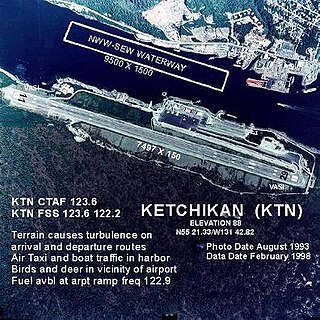
Ketchikan International Airport is a state-owned, public-use airport located one nautical mile (2 km) west of the central business district of Ketchikan, a city in Ketchikan Gateway Borough in Alaska, that has no direct road access to the outside world or to the airport. The airport is located on Gravina Island, just west of Ketchikan on the other side of the Tongass Narrows. Passengers must take a seven-minute ferry ride across the water to get to the airport from the town.

Catalina Airport is a privately owned airport located 6.4 miles (10.2 km) northwest of the central business district of Avalon, California, United States, in the middle of Catalina Island. The airport is open to the public and allows general aviation aircraft to land there. One-time landing fees are $38 for Piston single, $44 for Piston twin, $55 for Turbine single, $110 for Turbine twin. Overnight fees are $22 for a single engine or $27 twin engine. Operating hours are 8 a.m. – 5 p.m. The airport is primarily used for general aviation. The airport is also used for airfreight from the mainland. Supplies for the island are delivered daily.

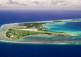
Tinian International Airport, also known as West Tinian Airport, is a public airport located on Tinian Island in the United States Commonwealth of the Northern Mariana Islands. This airport is owned by Commonwealth Ports Authority.

Montgomery-Gibbs Executive Airport is a public airport in San Diego, California, United States, six miles (10 km) north of downtown San Diego. The airport covers 456 acres (185 ha) and has three runways, one public helipad, and two private helipads. The runways are 28R/10L and 28L/10R (parallel) and 5/23.

Madang Airport, is an airport located in Madang, Papua New Guinea.

Faleolo International Airport is an airport located 40 kilometres (25 mi) west of Apia, the capital of Samoa. Until 1984, Faleolo could not accommodate jets larger than a Boeing 737. Services to the United States, Australia, or New Zealand, could only land at Pago Pago International Airport in American Samoa. Since the airport's expansion, most international traffic now uses Faleolo.

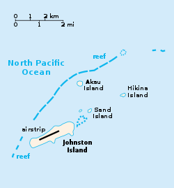
Johnston Island Air Force Base is a former United States Air Force base on the Johnston Atoll in the United States Minor Outlying Islands, in the Pacific Ocean several hundred kilometers southwest of Hawaii. After its closure, it briefly operated as Johnston Atoll Airport, until that also closed in 2005.

Raiatea Airport is an airport on Raiatea, French Polynesia. It is in the village of Uturoa. The airport was inaugurated in 1962, but did not see service in 1964. A backfilling was built on the north part of the island, as no appropriate site could be found on the coast. Many people use this airport to access the nearby island of Taha'a.

Wake Island Airfield is a military air base located on Wake Island, which is known for the Battle of Wake Island during World War II. It is owned by the U.S. Air Force and operated by the 611th Air Support Group. The runway can be used for emergency landings by commercial jetliners flying transpacific routes and has been used in the past by airlines operating jet, turboprop, and prop aircraft on scheduled flights.
Dyess Army Airfield is a military airfield on Roi-Namur, Kwajalein Atoll, Marshall Islands. It is owned by the United States Army. Approximately 60 U.S. personnel reside on the base, with an additional 100 personnel commuting from Bucholz Army Airfield daily by plane.
VPB-100 was a Patrol Bombing Squadron of the U.S. Navy. The squadron was established as Patrol Squadron 100 (VP-100) on 1 April 1944, redesignated Patrol Bombing Squadron 100 (VPB-100) on 1 October 1944 and disestablished on 15 December 1945.

Exmouth Submarine Base, called Operation Potshot, was a United States Navy base at Exmouth Gulf, Western Australia during World War II. Exmouth Gulf on western Australia was selected as the site for US Naval base as it was thought at the time to be out of the reach of Empire of Japan's long-range bombers. Bombing of Darwin on February 19, 1942, demonstrated a more southern port was needed. The Submarine operation at Exmouth Gulf and the North West Cape was called Operation Potshot, named after the Potshot airfield that provided fighter plane cover for the base.

Naval Base Gilbert Islands were naval bases built by the United States Navy in 1943 to support the World War II effort. The bases were located on in the Gilbert Islands in the Central Pacific Ocean. The bases were built as part of the many advance bases in the island-hopping campaign towards the Empire of Japan. The largest base was the Naval Base Tarawa. At Tarawa the Navy built a seaport, supply depots, a small ship repair depot, Carrier Aircraft Service Unit, seaplane base and two airbases. Construction started after the Battle of Tarawa ended on November 23, 1943, part of Operation Galvanic. The bases were built by the US Navy's Seabees, Naval Construction Battalions. After the war the bases were abandoned. Some of the airfields became civilian airports.