The New Zealand outlying islands are nine offshore island groups that are part of New Zealand, with all but Solander Islands lying beyond the 12nm limit of the mainland's territorial waters. Although considered integral parts of New Zealand, seven of the nine island groups are not part of any administrative region or district, but are instead each designated as an Area Outside Territorial Authority. The two exceptions are the Chatham Islands, which are covered by their own special territorial authority, and the Solander Islands, which are part of the Southland Region and Southland District.
Eight island groups sit on the New Zealand continental shelf, which forms a part of Zealandia. The Kermadec Islands, northeast of mainland New Zealand, are on a ridge, whose location as part or not part of Zealandia is not yet proven by geologists. [1] [2] Both sources show a map drawn of Zealandia, marking the location of islands north and south of New Zealand.
The term is also used sometimes to further encompass the Balleny Islands, a group of sub-Antarctic islands technically considered a part of the Ross Dependency and covered by the Antarctic Treaty.[ citation needed ]
The five island groups of the New Zealand Subantarctic Islands, including their territorial seas, are a World Heritage Site. [3]
The nine island groups classed as part of New Zealand's outlying islands are:
Map | Island group (other names) | Location | Coordinates | Area | Highest peak Altitude | Notes |
---|---|---|---|---|---|---|
Antipodes Islands [4] (Moutere Mahue) | New Zealand Subantarctic Islands, 860 kilometres (530 mi) east-southeast of Stewart Island / Rakiura | 49°41′S178°48′E / 49.683°S 178.800°E | 21 square kilometres (8.1 sq mi) | Mount Galloway 366 m (1,201 ft) | Part of the New Zealand Subantarctic Islands World Heritage Site | |
Auckland Islands [5] (Motu Maha, Maungahuka) | New Zealand Subantarctic Islands, 360 kilometres (220 mi) south-southwest of Stewart Island / Rakiura | 50°42′S166°05′E / 50.700°S 166.083°E | 625.64 square kilometres (241.56 sq mi) | Mount Dick 705 m (2,313 ft) | Part of the New Zealand Subantarctic Islands World Heritage Site | |
Bounty Islands [6] (Moutere Hauriri) | New Zealand Subantarctic Islands, roughly 670 km (416 mi) east-south-east of New Zealand's South Island and 530 km (329 mi) south-west of the Chatham Islands | 47°46′S179°02′E / 47.767°S 179.033°E | 1.35 square kilometres (0.52 sq mi) | Unnamed point on Funnel Island 73 m (240 ft) | Part of the New Zealand Subantarctic Islands World Heritage Site | |
Campbell Islands [7] (Motu Ihupuku) | New Zealand Subantarctic Islands, 620 kilometres (390 mi) SSW of Stewart Island / Rakiura | 52°32′S169°09′E / 52.533°S 169.150°E | 113.31 square kilometres (43.75 sq mi) | Mount Honey 558 m (1,831 ft) | Part of the New Zealand Subantarctic Islands World Heritage Site | |
Chatham Islands [8] (Rēkohu, Wharekauri) | South Pacific Ocean, roughly 800 kilometres (500 mi) east of New Zealand's South Island | 43°54′S176°32′W / 43.900°S 176.533°W | 966 square kilometres (373 sq mi) | Unnamed point on Chatham Island 299 m (981 ft) | Largest outlying island group, and the only one with a permanent population (720 as of June 2024 [9] ). | |
Kermadec Islands [10] (Rangitāhua) | South Pacific Ocean, roughly 800–1,000 kilometres (500–620 mi) north of New Zealand's North Island | 29°16′S177°55′W / 29.267°S 177.917°W | 33.6 square kilometres (13.0 sq mi) | Moumoukai Peak 516 m (1,693 ft) | 
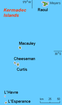
Northernmost outlying island group, consisting of a range of volcanic islands which are part of the wider Tonga-Kermadec Ridge. Despite having no permanent population, a meteorological station on Raoul Island is permanently staffed. | |
Manawatāwhi / Three Kings Islands [11] (Ngā Motu Karaka) | Convergence of the Tasman Sea and the South Pacific Ocean, roughly 55 kilometres (34 mi) northwest of Cape Reinga / Te Rerenga Wairua | 34°09′S172°08′E / 34.150°S 172.133°E | 6.85 square kilometres (2.64 sq mi) | Unnamed point on Manawatāwhi / Great Island 295 m (968 ft) | The islands are on a submarine plateau, the Three Kings Bank, and are separated from the New Zealand mainland by an 8 km wide, 200 to 300 m deep submarine trough | |
Snares Islands / Tini Heke [12] (Te Taniwha) | New Zealand Subantarctic Islands, 200 kilometres (120 mi) south of New Zealand's South Island | 48°01′S166°32′E / 48.017°S 166.533°E | 3.5 square kilometres (1.4 sq mi) | Unnamed point on North East Island 130 m (430 ft) | Part of the New Zealand Subantarctic Islands World Heritage Site. Given a dual name with the Ngāi Tahu Claims Settlement Act 1998. | |
Solander Islands / Hautere [13] | West of the Foveaux Strait, roughly 50 kilometres (31 mi) south of Fiordland on New Zealand's South Island | 46°34′S166°53′E / 46.567°S 166.883°E | 1.2 square kilometres (0.46 sq mi) | Unnamed point on Solander Island / Hautere 330 m (1,080 ft) | Only outlying island group to fall within the authority of a regional council, in this case Environment Southland. Given a dual name with the Ngāi Tahu Claims Settlement Act 1998. | |
The islands are all uninhabited except the Chatham Islands.
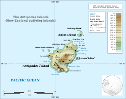
There is a staffed meteorological station on Raoul Island of the Kermadec Islands. The meteorological station on Campbell Island has been unstaffed and automated since 1995. There was a meteorological station on the Auckland Islands from 1942 to 1945. The Three Kings Islands and the Auckland Islands were formerly inhabited. There have been failed settlement attempts on Raoul Island, the Antipodes Islands and the Auckland Islands. The Solander Islands have never been inhabited except by shipwrecked sailors or marooned stowaways (for the longest period, from 1808 to 1813 by five European stowaways).
The Auckland Islands are an archipelago of New Zealand, lying 465 km (289 mi) south of the South Island. The main Auckland Island, occupying 460 km2 (180 sq mi), is surrounded by smaller Adams Island, Enderby Island, Disappointment Island, Ewing Island, Rose Island, Dundas Island, and Green Island, with a combined area of 570 km2 (220 sq mi). The islands have no permanent human inhabitants.
The Kermadec Islands are a subtropical island arc in the South Pacific Ocean 800–1,000 km northeast of New Zealand's North Island, and a similar distance southwest of Tonga. The islands are part of New Zealand. They are 33.6 km2 (13.0 sq mi) in total area and uninhabited, except for the permanently staffed Raoul Island Station, the northernmost outpost of New Zealand.
The Bounty Islands are a small group of uninhabited granite islets and numerous rocks, with a combined area of circa 50 ha in the South Pacific Ocean. Territorially part of New Zealand, they lie about 670 km (420 mi) east-south-east of New Zealand's South Island, 530 km (330 mi) south-west of the Chatham Islands, and 215 km (134 mi) north of the Antipodes Islands. The group is a World Heritage Site.
Campbell Island / Motu Ihupuku is an uninhabited subantarctic island of New Zealand, and the main island of the Campbell Island group. It covers 112.68 square kilometres (43.51 sq mi) of the group's 113.31 km2 (43.75 sq mi), and is surrounded by numerous stacks, rocks and islets like Dent Island, Folly Island, Isle de Jeanette-Marie, and Jacquemart Island, the latter being the southernmost extremity of New Zealand. The island is mountainous, rising to over 500 metres (1,640 ft) in the south. A long fiord, Perseverance Harbour, nearly bisects it, opening out to sea on the east coast.
The Snares Islands, known colloquially as The Snares, is a group of uninhabited islands lying about 200 km (120 mi) south of New Zealand's South Island and to the south-southwest of Stewart Island / Rakiura. The Snares consist of the main North East Island and the smaller Broughton Island and Alert Stack, as well as the Western Chain Islands some 5 km (3.1 mi) to the west-southwest. Collectively, the Snares have a total land area of 3.4 km2 (1.3 sq mi).
The Antipodes Islands are inhospitable and uninhabited volcanic islands in subantarctic waters to the south of – and territorially part of – New Zealand. The 21 km2 (8.1 sq mi) archipelago lies 860 km (530 mi) to the southeast of Stewart Island / Rakiura, and 730 km (450 mi) to the northeast of Campbell Island. They are very close to being the antipodal point of Normandy in France: the city farthest away is Cherbourg-en-Cotentin.
The Hen and Chicken Islands, usually known as the Hen and Chickens, lie to the east of the North Auckland Peninsula off the coast of northern New Zealand. They lie 12 kilometres (7.5 mi) east of Bream Head and 40 kilometres (25 mi) south-east of Whangārei with a total area of 8.44 km2 (3.26 sq mi).
The New Zealand Subantarctic Islands comprise the five southernmost groups of the New Zealand outlying islands. They are collectively designated as a UNESCO World Heritage Site.
New Zealand has 44 marine reserves that are spread around the North, the South Island, and neighbouring islands, and on outlying island groups. They are governed by the Marine Reserves Act 1971 and administered by the Department of Conservation with assistance from the Ministry for Primary Industries, New Zealand Customs Service and the New Zealand Defence Forces.
The Horoirangi Marine Reserve, sometimes referred to as the Glenduan Marine Reserve, is situated to the north east of Nelson in New Zealand. It stretches along the coast from the northern end of Boulder Bank to just south of Cable Bay.
The Campbell Islands are a group of subantarctic islands, belonging to New Zealand. They lie about 600 km south of Stewart Island. The islands have a total area of 113 km2 (44 sq mi), consisting of one big island, Campbell Island, and several small islets, notably Dent Island, Isle de Jeanette Marie, Folly Island, Jacquemart Island, and Monowai Island. Ecologically, they are part of the Antipodes Subantarctic Islands tundra ecoregion. The islands were gazetted as a nature reserve in 1954, and are one of five subantarctic island groups collectively designated as a World Heritage Site by UNESCO.
The Solander Islands / Hautere are three eroded remnant volcanic islets towards the western entrance of the Foveaux Strait just beyond New Zealand's South Island. The islands lie 40 km (25 mi) south of the coastline of Fiordland.
Cuvier Island is a small uninhabited island off the east coast of the North Island of New Zealand. It lies on the seaward end of the Colville Channel, 15 km (9.3 mi) north of the Mercury Islands and approximately 23 km (14 mi) south-east of Great Barrier Island. The 195 ha island is a wildlife sanctuary, managed by the Department of Conservation and is the subject of an ongoing island restoration project to eliminate non-native mammals and restore the original ecosystem. It is also the location of the Cuvier Island Lighthouse which was constructed in 1889 and the wreck of the old HMNZS Philomel which was scuttled near the island on 6 August 1949 after decommissioning and being stripped of useful equipment.
The Antarctic floristic kingdom, also the Holantarctic kingdom, is a floristic kingdom that includes most areas of the world south of 40°S latitude. It was first identified by botanist Ronald Good, and later by Armen Takhtajan. The Antarctic Floristic Kingdom is a classification in phytogeography, different from the Antarctic realm classification in biogeography, and from Antarctic flora genera/species classifications in botany.
Zealandia, also known as Te Riu-a-Māui (Māori) or Tasmantis, is an almost entirely submerged mass of continental crust in Oceania that subsided after breaking away from Gondwana 83–79 million years ago. It has been described variously as a submerged continent, continental fragment, and microcontinent. The name and concept for Zealandia was proposed by Bruce Luyendyk in 1995, and satellite imagery shows it to be almost the size of Australia. A 2021 study suggests Zealandia is over a billion years old, about twice as old as geologists previously thought.
Blumine Island / Ōruawairua is an island in the outer reaches of Queen Charlotte Sound / Tōtaranui, in the Marlborough Sounds at the northern end of New Zealand's South Island.
Kapiti Marine Reserve is a protected area on two sides of Kapiti Island, off the southern west coast of the North Island of New Zealand. It was created in 1992.
The Whangarei Harbour Marine Reserve is a protected area in the North Island of New Zealand. It was established in 2006 and measures 236.5 ha over two sites. The students and faculty of the nearby Kamo High School played an important role in establishing this reserve.
The Chetwode Islands are a group of islands near the Marlborough Sounds along the northern coast of the South Island of New Zealand.
Pohatu Marine Reserve is a 215 ha marine reserve centred on Flea Bay and lies between Ounu-hau Point and Redcliffe Point on Banks Peninsula in the Canterbury region of New Zealand. It was formally notified in 1999.
Several elevated bathymetric features north of Zealandia are possible candidates for Zealandia prolongations or separate microcontinents (Fig. 2). These include the Three Kings, Lau-Colville, and Tonga-Kermadec ridges and Fiji, which are known Cenozoic volcanic arcs (Graham, 2015), and the Mellish Rise and Louisiade and West Torres plateaus. However, no continental basement rocks have yet been sampled from any of these features, so their continental nature remains unproven.