Antipodes Islands

Last updated

Antipodes Islands
Antipodes Islands.jpg
The Antipodes Islands seen from the north
NZOffshoreIslandsMap.png
Position relative to New Zealand and other outlying islands
Geography
Location860 km southeast of Stewart Island
Coordinates 49°40′12″S178°46′48″E / 49.67000°S 178.78000°E / -49.67000; 178.78000
ArchipelagoAntipodes Islands
Major islandsAntipodes, Bollons
Area21 [1]  km2 (8.1 sq mi)
Highest elevation366 m (1201 ft)
Highest point Mount Galloway
Administration
New Zealand
Demographics
Population0 [2] (2006)
Additional information
Nature reserve

The Antipodes Islands (Māori : Moutere Mahue, lit.'Abandoned Island') are inhospitable and uninhabited volcanic islands in subantarctic waters to the south of – and territorially part of – New Zealand. The 21 km2 (8.1 sq mi) archipelago lies 860 km (530 mi) to the southeast of Stewart Island/Rakiura, and 730 km (450 mi) to the northeast of Campbell Island. [1] They are very close to being the antipodal point to Normandy in France, meaning that the city farthest away is Cherbourg-en-Cotentin, France.

Contents

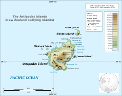
The island group consists of one main island, Antipodes Island, of 20 km2 (7.7 sq mi) area, Bollons Island to the north, and numerous small islets and stacks.

The islands are listed with the New Zealand Outlying Islands. The islands are an immediate part of New Zealand, but not part of any region or district, but instead Area Outside Territorial Authority, like all the other outlying islands except the Solander Islands.

Ecologically, the islands are part of the Antipodes Subantarctic Islands tundra ecoregion. The islands are inscribed on the UNESCO World Heritage List, together with other subantarctic New Zealand islands. The island group is a nature reserve and there is no general public access. They are the southeasternmost point of land in the world outside of Antarctica.

Etymology

The word antipodes derives from the Greek : ἀντίποδες, [3] plural of antipous (ἀντίπους) 'with feet opposite (ours)', from anti- 'opposed' and pous 'foot'. [4]

The island group was originally called the Penantipodes meaning 'next to the antipodes', because it lies near to the antipodes of London (located around 51.5°S, 180°W). Over time the name has been shortened to Antipodes. The island's actual antipodes are in the area of Barfleur, Normandy, close to the city of Cherbourg-en-Cotentin.

Geography

Topographical map Topographical map of the Antipodes Islands in English.svg
Topographical map

The volcanic Antipodes Islands lie 860 km (530 mi) southeast of Stewart Island/Rakiura. They consist of a main island (Antipodes Island), area 20 km2 (7.7 sq mi), surrounded by a series of small offshore islands and rocks. These islands include Bollons Island, at 0.5 km2 (0.19 sq mi) the second largest in the group, 1,200 m (3,900 ft) to the northeast of the main island's North Cape, and the nearby smaller Archway Island; Leeward Island, situated just off the centre of the main island's east coast (to which it is connected by a rocky bar at low tide); the two Windward Islands, situated 800 m (2,600 ft) apart, the easternmost of which is 600 m (2,000 ft) to the immediate north of Cave Point, the main island's westernmost point; and the tiny Orde Lees Islet, located close to the main island's northwestern shore. Numerous small islets and stacks further surround the coast of the main island.

The islands are steep, and cliffs and rocky reefs line the majority of the coasts. The highest point is Mount Galloway at 366 m (1,201 ft) in the north of the main island, which also forms part of the group's most recently active volcano. [5] Mount Waterhouse, to Galloway's southwest, also reaches over 360 m (1,180 ft). Several other heights on the main island reach above 200 m (660 ft), as does the highest point of Bollons Island. A ridge of peaks, the Reliance Ridge, runs along the main island's south coast. Several small streams run from the slopes of the main island's peaks, with the largest of these being the Dougall Stream, which runs northeast from the eastern slopes of Mount Waterhouse to reach the east coast not far from its closest point to Leeward Island. The Ringdove Stream runs east along the northern flanks of the Reliance Ridge to reach the large, rocky Ringdove Bay in the southeast of the main island. A further prominent stream runs southwest from the northwestern slopes of Mount Waterhouse to reach Stack Bay to the south of the Cave Point Peninsula, and a fourth runs north from the slopes of Mount Galloway, reaching the sea to the west of North Cape, close to Reef Point.

Islands

The following table includes named islands according to Land Information New Zealand. [6]

LocationArea
(ha)
Antipodes Island2,014.8
Bollons Island 52.6
Leeward Island12.5
East Windward Island8.5
West Windward Island7.0
Archway Island6.3
Orde Lees Islet1.8
Total
2,103.7

History

Prehistory

There is no archaeological evidence of human visitation prior to European discovery of the islands. Descriptions [7] of a shard of early Polynesian pottery having been discovered 76 cm (2 ft 6 in) below the surface on the main island in 1886, and housed in the collections of the Museum of New Zealand Te Papa Tongarewa are unsubstantiated. The museum has not been able to locate such a shard in its collection, and the original reference to the object in the museum's collection documentation indicates no reference to Polynesian influences. [8]

Sealing

The island group was seen on March 25, 1800, by Captain Henry Waterhouse commanding HMS Reliance. Matthew Flinders was first lieutenant, and his younger brother Samuel was a midshipman on the vessel; Samuel prepared the chart of the islands. [9] Waterhouse reported the presence of seals. In 1803 Waterhouse's brother-in-law George Bass applied to Governor Philip Gidley King of New South Wales for a fishing monopoly from a line bisecting southern New Zealand from Dusky Sound to the Otago Harbour to cover all the lands and seas to the south, including the Antipodes Islands, probably because he knew the latter were home to large populations of fur seals. [10] Bass sailed from Sydney to the south that year and was never heard of again, but his information led to a sealing boom at the islands in 1805 to 1807. In February 1805, the first sealing gangs arrived on the island from the American schooners Favorite and Independence . [11] They killed about 60,000 seals over the course of the year they were stationed on the islands.

At one time eighty men were present; there was a battle between American and British-led gangs and a single cargo of more than 80,000 skins—one of the greatest ever shipped from Australasia—was on-sold in Canton for one pound sterling a skin, a multimillion-dollar return in modern terms. Prominent Sydney merchants such as Simeon Lord, Henry Kable and James Underwood were engaged in the trade as well as the Americans Daniel Whitney and Owen Folger Smith. William W. Stewart, who claimed to have charted Stewart Island, and probably William Tucker who started the retail trade in preserved Maori heads, were present during the boom. After 1807, sealing was occasional and cargoes small, no doubt because the animals had been all but exterminated. [12]

Shipwrecks

Spirit of the Dawn's survivors landed at South Bay Antipodes South Bay.JPG
Spirit of the Dawn's survivors landed at South Bay

A much later attempt to establish cattle on the islands was short-lived (as were the cattle). When the ship Spirit of the Dawn (with a crew of 16) foundered off the main island's coast in 1893, the eleven surviving crew spent nearly three months living as castaways on the island, living on raw muttonbirds, mussels and roots for 87 days before gaining the attention of the government steamer NZGSS Hinemoa by a flag made from their sail.[ citation needed ]

Castaway hut at Antipodes' northern end Antipodes Castaway Hut.JPG
Castaway hut at Antipodes' northern end

A well-supplied castaway depot [13] was available on the other end of the island, but the survivors' weak condition and the island's mountainous terrain prevented them from searching for depots.

The depot was found and used by the crew of the French barque President Felix Faure, wrecked in Anchorage bay in 1908, who were stranded for sixty days until rescued by HMS Pegasus. [14]

The last wreck at the Antipodes was the yacht Totorore with the loss of two lives, Gerry Clark and Roger Sale, in June 1999. [15]

Nuclear testing proposals

In 1955 the British Government required a large site remote from population centres to test the new thermonuclear devices it was developing. Various islands in the South Pacific and Southern Oceans were considered, along with Antarctica. The Admiralty suggested the Antipodes Islands. [16]

Flora and fauna

Penguin colony in Anchorage Bay Antipodes Penguin.JPG
Penguin colony in Anchorage Bay

The flora of the islands has been recorded in detail, and includes megaherbs. The islands are also home to numerous bird species including the endemic Antipodes snipe, Antipodes parakeet, Reischek's parakeet, as well as several albatrosses, petrels and penguins, including half of the world population of the erect-crested penguin.

The original population of fur seals seems to be regionally extinct or in serious peril where "Upland Seals" once found on Antipodes and Macquarie Island have been claimed as a distinct subspecies with thicker furs by scientists although it is unclear whether these seals were genetically distinct. [17]

Important Bird Area

The Antipodes group has been identified as an Important Bird Area (IBA) by BirdLife International because of its significance as a breeding site for several species of seabirds. The seabirds are southern rockhopper and erect-crested penguins, Antipodean, black-browed, light-mantled and white-capped albatrosses, and northern giant, grey and white-chinned petrels. [18]

Conservation

As with many other islands, introduced rodents have caused problems by preying on the indigenous wildlife. A "Million Dollar Mouse" campaign was launched in 2012 to raise funds for an eradication programme as part of the New Zealand government's "Predator Free 2050" project. [19] In the winter of 2016, the Department of Conservation carried out bait drops totalling 65 tonnes from three helicopters, and searched with trained dogs for any remaining rodents, which eliminated the estimated 200,000 mice on Antipodes Island. [20] [21]

The island group is surrounded by the 2,173 km2 (839 sq mi) Moutere Mahue / Antipodes Island Marine Reserve. [22]

See also

Related Research Articles

<span class="mw-page-title-main">Auckland Islands</span> Volcanic archipelago in New Zealand

The Auckland Islands are an archipelago of New Zealand, lying 465 km (289 mi) south of the South Island. The main Auckland Island, occupying 460 km2 (180 sq mi), is surrounded by smaller Adams Island, Enderby Island, Disappointment Island, Ewing Island, Rose Island, Dundas Island, and Green Island, with a combined area of 570 km2 (220 sq mi). The islands have no permanent human inhabitants.

<span class="mw-page-title-main">Auckland Island</span> Island off Southern New Zealand

Auckland Island is the main island of the eponymous uninhabited archipelago in the Pacific Ocean. It is part of the New Zealand subantarctic area. It is inscribed in the UNESCO World Heritage list together with the other New Zealand Subantarctic Islands in the region.

<span class="mw-page-title-main">Bounty Islands</span> Island group in New Zealand

The Bounty Islands are a small group of uninhabited granite islets and numerous rocks, with a combined area of circa 50 ha in the South Pacific Ocean. Territorially part of New Zealand, they lie about 670 km (420 mi) east-south-east of New Zealand's South Island, 530 km (330 mi) south-west of the Chatham Islands, and 215 km (134 mi) north of the Antipodes Islands. The group is a World Heritage Site.

<span class="mw-page-title-main">Campbell Island, New Zealand</span> Island in New Zealand

Campbell Island / Motu Ihupuku is an uninhabited subantarctic island of New Zealand, and the main island of the Campbell Island group. It covers 112.68 square kilometres (43.51 sq mi) of the group's 113.31 km2 (43.75 sq mi), and is surrounded by numerous stacks, rocks and islets like Dent Island, Folly Island, Isle de Jeanette-Marie, and Jacquemart Island, the latter being the southernmost extremity of New Zealand. The island is mountainous, rising to over 500 metres (1,640 ft) in the south. A long fiord, Perseverance Harbour, nearly bisects it, opening out to sea on the east coast.

<span class="mw-page-title-main">Snares Islands</span> Island group in New Zealand

The Snares Islands, known colloquially as The Snares, is a group of uninhabited islands lying about 200 km (120 mi) south of New Zealand's South Island and to the south-southwest of Stewart Island / Rakiura. The Snares consist of the main North East Island and the smaller Broughton Island and Alert Stack, as well as the Western Chain Islands some 5 km (3.1 mi) to the west-southwest. Collectively, the Snares have a total land area of 3.4 km2 (1.3 sq mi).

<span class="mw-page-title-main">New Zealand Subantarctic Islands</span> Southernmost parts of the South Pacific country

The New Zealand Subantarctic Islands comprise the five southernmost groups of the New Zealand outlying islands. They are collectively designated as a UNESCO World Heritage Site.

<span class="mw-page-title-main">Campbell Islands</span> Island group in New Zealand

The Campbell Islands are a group of subantarctic islands, belonging to New Zealand. They lie about 600 km south of Stewart Island. The islands have a total area of 113 km2 (44 sq mi), consisting of one big island, Campbell Island, and several small islets, notably Dent Island, Isle de Jeanette Marie, Folly Island, Jacquemart Island, and Monowai Island. Ecologically, they are part of the Antipodes Subantarctic Islands tundra ecoregion. The islands are one of five subantarctic island groups collectively designated as a World Heritage Site by UNESCO.

<span class="mw-page-title-main">Bollons Island</span> Island in Antipodes Islands group

Bollons Island is a small island in New Zealand's subantarctic Antipodes Islands group. It is the second largest island in the group behind Antipodes Island.

<span class="mw-page-title-main">Disappointment Island</span> Island off southern New Zealand

Disappointment Island is one of seven uninhabited islands in the Auckland Islands archipelago, in New Zealand. It is 475 kilometres (295 mi) south of the country's main South Island and 8 kilometres (5 mi) from the northwest end of Auckland Island. It is home to a large colony of white-capped albatrosses: about 65,000 pairs – nearly the entire world's population – nest there. Also on the island is the Auckland rail, endemic to the archipelago; once thought to be extinct, it was rediscovered in 1966.

<i>Dundonald</i> (ship) Former British barque

Dundonald was a British four-masted steel barque measuring 2,205 gross register tons launched in Belfast in 1891. It was involved in a wreck in 1907 in the New Zealand Subantarctic Islands. Only 15 of its 28 crew survived; they were rescued seven months later by a scientific expedition.

<span class="mw-page-title-main">Castaway depot</span> Hut or store used to aid persons lost at sea

A castaway depot is a store or hut placed on an isolated island to provide emergency supplies and relief for castaways and victims of shipwrecks.

NZGSS <i>Hinemoa</i> New Zealand Government Service Steamer designed for lighthouse support and servicing

NZGSS Hinemoa was a 542-ton New Zealand Government Service Steamer designed specifically for lighthouse support and servicing, and also for patrolling New Zealand's coastline and carrying out castaway checks and searching for missing ships. It operated in New Zealand's territorial waters from 1876 to 1944.

<span class="mw-page-title-main">John Bollons</span>

John Peter Bollons was a New Zealand marine captain, naturalist and ethnographer. For many years he captained New Zealand government steamers, including the NZGSS Hinemoa, which undertook lighthouse work and patrols through New Zealand's subantarctic islands. Bollons Island, in the Antipodes Islands, is named after him. In 1928 he was appointed a Companion of the Imperial Service Order.

<span class="mw-page-title-main">Geography of Tristan da Cunha</span>

Tristan da Cunha is an archipelago of five islands in the southern Atlantic Ocean, the largest of which is the island of Tristan da Cunha itself and the second-largest, the remote bird haven, Gough Island. It forms part of a wider territory called Saint Helena, Ascension and Tristan da Cunha which includes Saint Helena and Ascension Island.

The Antipodes snipe, also known as the Antipodes Island snipe, is an isolated subspecies of the Subantarctic snipe that is endemic to the Antipodes Islands, a subantarctic island group south of New Zealand in the Southern Ocean.

<span class="mw-page-title-main">Lower Moutere</span> Rural locality in Tasman, New Zealand

Lower Moutere is a settlement in the Tasman District of New Zealand's upper South Island. It is a farming community it the Lower Moutere valley, 6 km (3.7 mi) from Motueka close to the Moutere Inlet.

<span class="mw-page-title-main">Moutere Ihupuku / Campbell Island Marine Reserve</span>

Moutere Ihupuku / Campbell Island Marine Reserve or Campbell Island / Moutere Ihupuku Marine Reserve is a marine reserve around Campbell island in the New Zealand Subantarctic Islands.

<span class="mw-page-title-main">Moutere Mahue / Antipodes Island Marine Reserve</span> Marine reserve in New Zealand territorial waters

Moutere Mahue / Antipodes Island Marine Reserve is a marine reserve covering an area of 217,287 hectares around the Antipodes Islands south of New Zealand's South Island and Stewart Island / Rakiura. It was established in 2014 and is administered by the New Zealand Department of Conservation.

Moutere Hauriri / Bounty Islands Marine Reserve is a marine reserve covering an area of 104,626 hectares around New Zealand's Bounty Islands. It was established in 2014 and is administered by the Department of Conservation.

<span class="mw-page-title-main">Depot Island (Bounty Islands)</span> Island in the Bounty Islands, New Zealand

Depot Island is the largest island in the Bounty Islands, a chain of uninhabited subantarctic islands 800 kilometres off the southeast coast of New Zealand's South Island. The island is an important bird nesting site, and is located within the Bounty Islands/Moutere Hauriri Marine Reserve.

References

  1. 1 2 "Antipodes Islands". doc.govt.nz. Retrieved 7 February 2024.
  2. Final counts – census night and census usually resident populations, and occupied dwellings – Area outside territorial authority Archived 25 May 2010 at the Wayback Machine , 2006 Census, Statistics New Zealand. Retrieved 26 August 2010.
  3. Antipodes, Liddell and Scott, "A Greek-English Lexicon", on Perseus.
  4. antipodes, Online Etymology Dictionary
  5. "Antipodes Island". Global Volcanism Program . Smithsonian Institution . Retrieved 6 March 2018.
  6. "NZ Primary Parcels". linz.govt.nz. Retrieved 7 February 2024.
  7. "NGA-IWI-O-AOTEA". Te Ao Hou. 1967. Retrieved 9 July 2012.
  8. "Captain Fairchild to the Secretary, Marine Department, Wellington". Appendix to the Journals of the House of Representatives, 1886 Session I, H-24. Wellington: Marine Department. p. 6. Retrieved 9 July 2012.
  9. Rowley Taylor, Straight through from London: the Antipodes and Bounty Islands, New Zealand, Christchurch, Heritage Expeditions New Zealand, 2006, p.34. Isle Penantipode, discovered by HMS Reliance, H.Waterhouse, commander, March 25, 1800.
  10. Keith Macrae Bowden, George Bass, 1771–1803: his discoveries, romantic life and tragic disappearance, Melbourne, Oxford University Press, 1952, pp.118–119.
  11. The Sydney Gazette, 5 May 1805; 16 March 1806.
  12. Peter Entwisle, Taka: a Vignette life of William Tucker 1784–1817: Convict, Sealer, Trader in Human Heads, Otago Settler, New Zealand's First Art Dealer, Dunedin, Port Daniel Press, 2005, p.40-41.
  13. Items from the 1880s depot recovered in 1947 and now in the collection of the Museum of New Zealand Te Papa Tongarewa
  14. "Castaways rescued". Evening Post. New Zealand. 16 May 1908. p. 6.
  15. Imber, Michael J.; Scofield, R. Paul; Goodwin, Anthea; Tennyson, Alan J.D. (2000). "Obituary – Gerald Stanley (Gerry) Clark (1927–1999)" (PDF). Notornis. 49 (1): 55–58. Archived from the original (PDF) on 18 October 2008.
  16. Arnold & Pyne 2001, p. 96.
  17. Richards, Rhys (1994). ""The upland seal" of the Antipodes and Macquarie Islands: A historian's perspective". Journal of the Royal Society of New Zealand. 24 (3): 289–295. Bibcode:1994JRSNZ..24..289R. doi: 10.1080/03014223.1994.9517473 .
  18. BirdLife International. (2012). Important Bird Areas factsheet: Antipodes Islands. Downloaded from "BirdLife International – conserving the world's birds". Archived from the original on 10 July 2007. Retrieved 7 May 2013. on 27 January 2012.
  19. "Department of Conservation selling access to rare species". Stuff.co.nz. 10 June 2012. Retrieved 14 June 2012.
  20. "Million Dollar Mouse successfully eradicates mice from Antipodes Island". The Beehive. Retrieved 20 March 2018.
  21. Shuklin, George (21 March 2018). "NZ hails 'Million Dollar Mouse' success". BBC News. Retrieved 23 March 2018.
  22. "Data Table – Protected Areas – LINZ Data Service (recorded area 217286.6633 ha)". Land Information New Zealand. Retrieved 27 August 2019.

Further reading