Antipodes Subantarctic Islands tundra

Last updated
Antipodes Subantarctic Islands tundra
MacquarieIsland11.JPG
Bluffs on Macquarie Island
NZOffshoreIslandsMap.png
The position of the Antipodes Subantarctic Islands relative to New Zealand
Ecology
Realm Australasian
Biome tundra
Geography
Area817 km2 (315 sq mi)
Countries Australia and New Zealand
Coordinates 50°43′S166°07′E / 50.71°S 166.11°E / -50.71; 166.11 Coordinates: 50°43′S166°07′E / 50.71°S 166.11°E / -50.71; 166.11
Conservation
Conservation status Relatively stable/intact
Protected116 km² (14%) [1]

The Antipodes Subantarctic Islands tundra ecoregion, within the tundra biome, includes five remote island groups in the Pacific Ocean south of New Zealand: the Bounty Islands, Auckland Islands, Antipodes Islands and Campbell Island groups of New Zealand, and Macquarie Island of Australia. [2] [3] [4]

Contents

Location and description

An old castaway hut on the Antipodes Islands. Antipodes Castaway Hut.JPG
An old castaway hut on the Antipodes Islands.

The islands constituting this ecoregion share a long history of isolation, both from other landmasses and each other. The isolation, combined with harsh climates characterised by low temperatures, strong westerly winds and few hours of sunlight in winter, have resulted in the evolution of many endemic plants and animals, though species richness is relatively low. Wind speeds reach an average of 40 km/h (25 mph) while even in summer the thick cloud cover prevents much sunlight from penetrating.

The Bounty Islands are small granite rocks (with a maximum height of 88 m or 289 ft), while the small Antipodes Islands group (maximum height 366 m), the largest group the Auckland Islands (705 m or 2,313 ft) and Campbell Island (569 m or 1,867 ft) are volcanic in origin. Macquarie Island (433 m or 1,421 ft) is the furthest south and the coldest. Where present, soils are mainly boggy peats, up to 8 m (26.2 ft) deep in flat areas. None of the islands are inhabited although there are ongoing research projects including a permanent base of the Australian Antarctic Division on Macquarie Island.

Flora

Vegetation may include low forests of Southern rātā in the more sheltered areas of the Aucklands and parts of Campbell Island, with tussock grassland, shrubland, herbfield, feldmark and cushion plants elsewhere. The islands represent a transition zone between the Antarctic to the south and temperate climates to the north. Individual species include many endemics, such as a Cyathea tree fern, which are not found any further south in the world, along with others that also occur in New Zealand and further north. Macquarie Island, being colder (average annual temperature 5 °C or 41 °F), does not sustain any wooded plants, while the small Bounty Islands lack soils and their flora is largely restricted to algae and lichens on the rocks. The islands are home to a number of rare plants, including a unique genus, the Auckland Island Pleurophyllum , and the only subantarctic orchids, Corybas dienemus and Corybas sulcatus of Macquarie Island. [2]

Fauna

There are no native land mammals, nor amphibians or reptiles. Marine mammals include five breeding species of seal; the southern elephant seal, Australasian fur seal, subantarctic fur seal, Antarctic fur seal and the rare New Zealand sea lion, 95% of the world's population of which breed on the Auckland Islands.

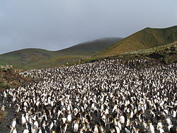
There are also large numbers of breeding penguins and other seabirds, including almost half of the world's species of albatross, especially the world's only breeding colonies of the Antipodean albatross (Diomedea exulans antipodensis), southern royal albatross (Diomedea epomophora epomophora), Campbell albatross (Thalassarche impavida), white-capped albatross (Thalassarche steadi), and Salvin's albatross (Thalassarche salvini). The large colonies of Salvin's albatross on the Bounty Islands build nests of feathers as there is no vegetation to use. There are also isolated populations of land birds that have presumably settled here, having been blown off course by ocean winds. Many of these have since evolved into unique species, including two endemic parakeets on Antipodes Island; the Antipodes parakeet (Cyanoramphus unicolor) and Reischek's parakeet (Cyanoramphus hochstetteri).

A royal penguin rookery on Macquarie Island. RoyalPenguins4.JPG
A royal penguin rookery on Macquarie Island.

Similarly, a high proportion of the Lepidoptera and other insects of the islands have evolved into unique endemic species.

A number of species have disappeared since the islands were discovered by humans, including the Macquarie Island rail and the Macquarie Island parakeet. [2]

Threats and preservation

Although the islands have been partially occupied at various times the habitats remain largely unspoilt. However, introduced animals prey on native wildlife and graze on the plant cover while both mammals and seabirds are vulnerable to entanglement in deep-sea fishing equipment. Longline fishing for tuna and trawling for squid are particularly damaging.

Current predators on the islands include rats and cats which are being systematically removed while cautionary procedures have been implemented to prevent more alien species from establishing. All cats have now been removed from Macquarie Island and there appears to have been an immediate increase in some seabird populations. All of the islands are nature reserves, World Heritage Sites and (except for the Bounty Islands) a Centre of Plant Diversity. Permission to land must be obtained from the Department of Conservation (New Zealand) for the New Zealand islands and the Tasmania Parks and Wildlife Service for Macquarie.

Related Research Articles

<span class="mw-page-title-main">Tundra</span> Biome where plant growth is hindered by frigid temperatures

In physical geography, tundra is a type of biome where tree growth is hindered by frigid temperatures and short growing seasons. The term tundra comes through Russian тундра from the Kildin Sámi word тӯндар meaning "uplands", "treeless mountain tract". There are three regions and associated types of tundra: Arctic tundra, alpine tundra, and Antarctic tundra.

<span class="mw-page-title-main">Auckland Islands</span> Volcanic archipelago of New Zealands subantarctic islands

The Auckland Islands are an archipelago of New Zealand, lying 465 kilometres (290 mi) south of the South Island. The main Auckland Island, occupying 510 km2 (200 sq mi), is surrounded by smaller Adams Island, Enderby Island, Disappointment Island, Ewing Island, Rose Island, Dundas Island, and Green Island, with a combined area of 626 km2 (240 sq mi). The islands have no permanent human inhabitants.

<span class="mw-page-title-main">Macquarie Island</span> Sub-Antarctic island of Australia

Macquarie Island is an island in the southwestern Pacific Ocean, about halfway between New Zealand and Antarctica. Regionally part of Oceania and politically a part of Tasmania, Australia, since 1900, it became a Tasmanian State Reserve in 1978 and was inscribed as a UNESCO World Heritage Site in 1997.

<i>Cyanoramphus</i> Genus of birds

Cyanoramphus is a genus of parakeets native to New Zealand and islands of the southern Pacific Ocean. The New Zealand forms are often referred to as kākāriki. They are small to medium-sized parakeets with long tails and predominantly green plumage. Most species are forest species, although several of the subantarctic species live in open grassland. The genus formerly had a disjunct distribution, with two species found in the Society Islands and the majority of the genus ranging from New Caledonia to Macquarie Island, but absent from the 4,100 km (2,500 mi) in between. Despite many fossil birds being found in the islands between these two areas being found none of these were of undescribed Cyanoramphus species.

<span class="mw-page-title-main">Bounty Islands</span> 13 islets and rocks in the subantarctic South Pacific administered by New Zealand

The Bounty Islands are a small group of 13 uninhabited granite islets and numerous rocks, with a combined area of 135 ha, in the South Pacific Ocean. Territorially part of New Zealand, they lie about 670 km (416 mi) east-south-east of New Zealand's South Island, 530 km (329 mi) south-west of the Chatham Islands, and 215 km (134 mi) north of the Antipodes Islands. The group is a World Heritage Site.

<span class="mw-page-title-main">Campbell Island, New Zealand</span> Island in New Zealand

Campbell Island / Motu Ihupuku is an uninhabited subantarctic island of New Zealand, and the main island of the Campbell Island group. It covers 112.68 square kilometres (43.51 sq mi) of the group's 113.31 km2 (43.75 sq mi), and is surrounded by numerous stacks, rocks and islets like Dent Island, Folly Island, Isle de Jeanette-Marie, and Jacquemart Island, the latter being the southernmost extremity of New Zealand. The island is mountainous, rising to over 500 metres (1,640 ft) in the south. A long fiord, Perseverance Harbour, nearly bisects it, opening out to sea on the east coast.

<span class="mw-page-title-main">Antipodes Islands</span> Subantarctic archipelago of New Zealand

The Antipodes Islands are inhospitable and uninhabited volcanic islands in subantarctic waters to the south of – and territorially part of – New Zealand. The 21 km2 archipelago lies 860 km to the southeast of Stewart Island/Rakiura, and 730 km to the northeast of Campbell Island. They are very close to being the antipodal point to Normandy in France, meaning that the city farthest away is Cherbourg-en-Cotentin, France.

<span class="mw-page-title-main">Scotia Sea</span> Sea at the northern edge of the Southern Ocean at its boundary with the South Atlantic Ocean

The Scotia Sea is a sea located at the northern edge of the Southern Ocean at its boundary with the South Atlantic Ocean. It is bounded on the west by the Drake Passage and on the north, east, and south by the Scotia Arc, an undersea ridge and island arc system supporting various islands. The sea sits atop the Scotia Plate. It is named after the expedition ship Scotia. Many icebergs melt there.

<span class="mw-page-title-main">Campbell Islands</span> Group of subantarctic South Pacific islands, administered by New Zealand

The Campbell Islands are a group of subantarctic islands, belonging to New Zealand. They lie about 600 km south of Stewart Island. The islands have a total area of 113.31 km2 (43.75 sq mi), consisting of one big island, Campbell Island, and several small islets, notably Dent Island, Isle de Jeanette Marie, Folly Island, Jacquemart Island, and Monowai Island. Ecologically, they are part of the Antipodes Subantarctic Islands tundra ecoregion. The islands are one of five subantarctic island groups collectively designated as a World Heritage Site by UNESCO.

<span class="mw-page-title-main">Southern royal albatross</span> Species of bird

The southern royal albatross is a large seabird from the albatross family. At an average wingspan of above 3 m (9.8 ft), it is one of the two largest species of albatross, together with the wandering albatross. Recent studies indicate that the southern royal albatross may, on average, be somewhat larger than the wandering albatross in mass and have a similar wingspan, although other sources indicate roughly similar size for the two species and the wandering species may have a larger average wingspan in some colonies.

<span class="mw-page-title-main">Campbell Plateau</span> Large oceanic plateau south of New Zealand and the Chatham Rise

The Campbell Plateau is a large oceanic plateau south of New Zealand and the Chatham Rise. It originated in the Gondwanan breakup and is part of Zealandia, a largely submerged continent. The above sea level parts of the plateau — the Bounty Islands, Antipodes Islands, Auckland Islands and Campbell Island — form part of the New Zealand Subantarctic Islands which were declared a World Heritage Site in 1998. Large parts of the Campbell Plateau lie less than 1000 m below sea level. It rises to 500 m at the Pukaki Rise and emerges above sea level at the Auckland and Campbell Islands.

<span class="mw-page-title-main">Southern Indian Ocean Islands tundra</span> Ecoregion of several subantarctic islands in the southern Indian Ocean

The Southern Indian Ocean Islands tundra is a tundra ecoregion that includes several subantarctic islands in the southern Indian Ocean.

<span class="mw-page-title-main">Reischek's parakeet</span> Species of bird

Reischek's parakeet is a small green parrot confined to 21 km2 (8.1 sq mi) Antipodes Island, one of New Zealand’s subantarctic islands, which it shares with a congener, the larger Antipodes parakeet.

References

  1. Dinerstein, Eric; Olson, David; et al. (June 2017). "An Ecoregion-Based Approach to Protecting Half the Terrestrial Realm". BioScience. 67 (6): 534–545. doi: 10.1093/biosci/bix014 . PMC   5451287 . PMID   28608869.{{cite journal}}: CS1 maint: date and year (link) Supplemental material 2 table S1b.
  2. 1 2 3 "Antipodes Subantarctic Islands tundra". Terrestrial Ecoregions. World Wildlife Fund.
  3. "Map of Ecoregions 2017". Resolve. Retrieved August 20, 2021.
  4. "Antipodes Subantarctic Islands tundra". The Encyclopedia of Earth. Retrieved August 20, 2021.