Tasmania Parks and Wildlife Service is the government body responsible for managing protected areas of Tasmania on public land, such as national parks, historic sites and regional reserves. Historically it has also had responsibility for managing wildlife, including game.
The National Parks and Wildlife Service was set up on 1 November 1971 after controversy surrounding the proposal to flood Lake Pedder and the unsuccessful attempts to prevent the project going ahead.[1] A Select Committee formed from the interested parties recommended the establishment of a professional park service to properly manage the natural environment in Tasmania, and to replace the former Scenery Preservation[2] and Animals & Birds Protection Boards,[3] previously responsible for scenic reserves (including national parks) and wildlife sanctuaries respectively.
Lake Pedder in 1970 before it was flooded, part of Lake Pedder National Park from 1955 and Southwest National Park from 1968. The furore surrounding the flooding led directly to the formation of the National Parks and Wildlife Service, the forerunner of Tasmania Parks and Wildlife Service.
Until 1987 the service operated relatively independently and, since then, has had a chequered history within the structure of the Tasmanian bureaucracy, being initially merged in that year with the Department of Lands, to form the Department of Lands, Parks and Wildlife,[7] and relocated to new premises.
In 1989 the Department of Lands, Parks and Wildlife split to become the Department of Environment and Planning[8] and the Department of Parks, Wildlife and Heritage,[9] which managed Crown land as well as the reserves, and with duties to conserve wildlife and historic heritage sites. The Royal Tasmanian Botanical Gardens and the Port Arthur Historic Site Management Authority also became part of this new Department.
On 3 February 1993, the Department once again merged, this time becoming the Department of Environment and Land Management (DELM),[10] with the Parks and Wildlife Service functioning as a separate division.[11] In that year the introduction of park fees allowed the service to fund projects aimed at visitors including visitor centres and official trails.
In 1995 several areas of land previously managed by the service were transferred to the Aboriginal Land Council of Tasmania and an Aboriginal Heritage Unit was created to provide training for Aboriginal community members, to help facilitate their advising on Aboriginal heritage management.
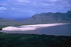
Wineglass Bay, part of Freycinet National Park which was expanded under the Regional Forest Agreement
Under the 1998 Tasmanian Regional Forest Agreement (RFA) an extra 3,960 square kilometres (1,530sqmi) of public land were added to Tasmania's reserves, expanding the amount of public land in reserves by 17%. The RFA also expanded Mount William and Freycinet National Parks, and created Tasman and Savage River National Parks. Offsetting these gains were 700 square kilometres (270sqmi) of reserves that were made available for forestry development.
A further departmental merger occurred after the 1998 state elections with the Department of Primary Industries and Fisheries, and the Government Analytical and Forensic Laboratories (GAFL) coming on board, creating the Department of Primary Industries, Water and Environment (DPIWE). The Parks and Wildlife Service was split into two separate divisions: the Resource Management and Conservation Division had responsibility for natural and cultural resources, and the Parks and Wildlife Service covered Tasmania's parks, reserves and World Heritage Areas.
In April 1999 an existing reserve on Flinders Island, known since 1967 as Strzelecki National Park, was formally named as such.
In August 2000, state waters surrounding sub-antarctic Macquarie Island were declared a marine protected area around 747 square kilometres (288sqmi) in area.
The Parks and Wildlife Service was separated from the DPIWE following the 2002 state elections, becoming part of the Department of Tourism, Parks, Heritage and the Arts (DTPHA), while the Resource Management and Conservation Division remained part of the DPIWE.
In April 2006 the DTPHA incorporated the Environment Division from the DPIWE, becoming the Department of Tourism, Arts and the Environment[12] and, subsequently, in March 2008, the Department of Environment, Parks, Heritage and the Arts (DEPHA).[13]
In 2007 the Tasmanian Coast Conservation Fund was established. Tour company operator Robert Pennicott, founder of Bruny Island Cruises and Tasman Island Cruises, came together with environmental group WILDCARE to establish the fund. While operating separately to the Tasmanian Parks and Wildlife Service, the fund is used to provide funding to the Parks and Wildlife Service to assist in environmental protection and conservation projects in Tasmania's National Parks.[14]
From July 2009, the DEPHA ceased to exist, and the Parks and Wildlife Service became part of the new Department of Primary Industries, Parks, Water and Environment (DPIPWE).
↑ "Lyre Birds for Tasmania". The Age. No.25, 612. Victoria, Australia. 19 May 1937. p.12. Retrieved 30 March 2024– via National Library of Australia.
↑ Murrell, Peter; Tasmania. National Parks and Wildlife Service (1979), A proposal for a Wild River National Park, the Franklin-Lower Gordon Rivers: submitted to the Minister for National Parks and Wildlife ..., National Parks and Wildlife Service, ISBN978-0-7246-0904-8
↑ Tasmania. Parks and Wildlife Service (2004), Parks and Wildlife Service, Tasmania. Parks and Wildlife Service, retrieved 30 March 2024
↑ Annual report, Department of Tourism, Arts and the Environment, 2006, retrieved 30 March 2024
↑ Tasmania. Department of Environment, Parks, Heritage and the Arts (2008), Annual report, Department of Environment, Parks, Heritage and the Arts, retrieved 30 March 2024{{citation}}: CS1 maint: multiple names: authors list (link)
This page is based on this Wikipedia article Text is available under the CC BY-SA 4.0 license; additional terms may apply. Images, videos and audio are available under their respective licenses.