
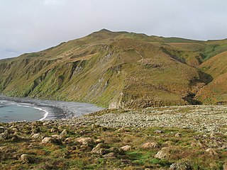
The Auckland Islands are an archipelago of New Zealand, lying 465 km (289 mi) south of the South Island. The main Auckland Island, occupying 460 km2 (180 sq mi), is surrounded by smaller Adams Island, Enderby Island, Disappointment Island, Ewing Island, Rose Island, Dundas Island, and Green Island, with a combined area of 570 km2 (220 sq mi). The islands have no permanent human inhabitants.

The Bounty Islands are a small group of uninhabited granite islets and numerous rocks, with a combined area of circa 50 ha in the South Pacific Ocean. Territorially part of New Zealand, they lie about 670 km (420 mi) east-south-east of New Zealand's South Island, 530 km (330 mi) south-west of the Chatham Islands, and 215 km (134 mi) north of the Antipodes Islands. The group is a World Heritage Site.

Campbell Island / Motu Ihupuku is an uninhabited subantarctic island of New Zealand, and the main island of the Campbell Island group. It covers 112.68 square kilometres (43.51 sq mi) of the group's 113.31 km2 (43.75 sq mi), and is surrounded by numerous stacks, rocks and islets like Dent Island, Folly Island, Isle de Jeanette-Marie, and Jacquemart Island, the latter being the southernmost extremity of New Zealand. The island is mountainous, rising to over 500 metres (1,640 ft) in the south. A long fiord, Perseverance Harbour, nearly bisects it, opening out to sea on the east coast.

The Snares Islands, known colloquially as The Snares, is a group of uninhabited islands lying about 200 km (120 mi) south of New Zealand's South Island and to the south-southwest of Stewart Island / Rakiura. The Snares consist of the main North East Island and the smaller Broughton Island and Alert Stack, as well as the Western Chain Islands some 5 km (3.1 mi) to the west-southwest. Collectively, the Snares have a total land area of 3.4 km2 (1.3 sq mi).

The Antipodes Islands are inhospitable and uninhabited volcanic islands in subantarctic waters to the south of – and territorially part of – New Zealand. The 21 km2 (8.1 sq mi) archipelago lies 860 km (530 mi) to the southeast of Stewart Island / Rakiura, and 730 km (450 mi) to the northeast of Campbell Island. They are very close to being the antipodal point of Normandy in France: the city farthest away is Cherbourg-en-Cotentin.
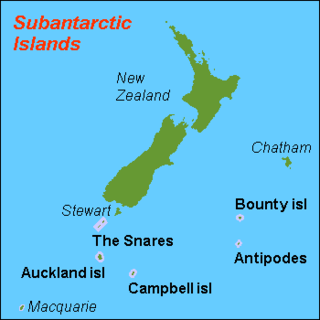
The New Zealand Subantarctic Islands comprise the five southernmost groups of the New Zealand outlying islands. They are collectively designated as a UNESCO World Heritage Site.
The Antipodes Subantarctic Islands tundra ecoregion, within the tundra biome, includes five remote island groups in the Pacific Ocean south of New Zealand: the Bounty Islands, Auckland Islands, Antipodes Islands and Campbell Island groups of New Zealand, and Macquarie Island of Australia.

The Campbell Islands are a group of subantarctic islands, belonging to New Zealand. They lie about 600 km south of Stewart Island. The islands have a total area of 113 km2 (44 sq mi), consisting of one big island, Campbell Island, and several small islets, notably Dent Island, Isle de Jeanette Marie, Folly Island, Jacquemart Island, and Monowai Island. Ecologically, they are part of the Antipodes Subantarctic Islands tundra ecoregion. The islands are one of five subantarctic island groups collectively designated as a World Heritage Site by UNESCO.

Enderby Island is part of New Zealand's uninhabited Auckland Islands archipelago, south of mainland New Zealand. It is situated just off the northern tip of Auckland Island, the largest island in the archipelago.

Cape Rodney-Okakari Point Marine Reserve is a 5.5 km2 (2.1 sq mi) protected area in the North Island of New Zealand. All fishing, and the removal or disturbing of marine life or materials, is forbidden within the reserve.
Hawea Marine Reserve is a marine reserve covering an area of 411 hectares in Hāwea / Bligh Sound, in Fiordland on New Zealand's South Island. It was established in 2005 and is administered by the Department of Conservation.

Ulva Island-Te Wharawhara Marine Reserve is a marine reserve covering an area of 1,075 hectares south-west and north-east of Ulva Island, in the Paterson Inlet of New Zealand's Stewart Island. It was established in 2004 and is administered by the Department of Conservation.

Hikurangi Marine Reserve is a marine reserve off the coast of the Kaikōura District, in the Canterbury Region of New Zealand's South Island. It is the largest and deepest marine reserve in New Zealand.
Long Island-Kokomohua Marine Reserve is a marine reserve, in the Marlborough Region of New Zealand's South Island. It covers an area of 619 hectares at the entrance to the Queen Charlotte Sound in the Marlborough Sounds. It was the first marine reserve established on the South Island.

Moutere Ihupuku / Campbell Island Marine Reserve or Campbell Island / Moutere Ihupuku Marine Reserve is a marine reserve around Campbell island in the New Zealand Subantarctic Islands.
Moutere Hauriri / Bounty Islands Marine Reserve is a marine reserve covering an area of 104,626 hectares around New Zealand's Bounty Islands. It was established in 2014 and is administered by the Department of Conservation.

Kutu Parera Marine Reserve is a marine reserve covering an area of 433 hectares at Gaer Arm in the Bradshaw Sound of Fiordland on New Zealand's South Island. It was established in 2005 and is administered by the Department of Conservation.
Moana Uta Marine Reserve is a marine reserve covering the entire length of Wet Jacket Arm in Fiordland on New Zealand's South Island, an area of 2,007 hectares. It was established in 2005 and is administered by the Department of Conservation.
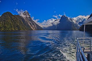
Piopiotahi Marine Reserve is a marine reserve covering an area of 690 hectares in the Milford Sound / Piopiotahi, in Fiordland on New Zealand's South Island. It was established in 1993 and is administered by the Department of Conservation.

Taipari Roa Marine Reserve is a marine reserve covering an area of 613 hectares around Elizabeth Island, in the inner Doubtful Sound / Patea of Fiordland on New Zealand's South Island. It was established in 2005 and is administered by the Department of Conservation.

