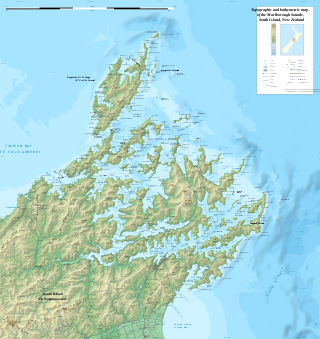
The Marlborough Sounds are an extensive network of sea-drowned valleys at the northern end of the South Island of New Zealand. The Marlborough Sounds were created by a combination of land subsidence and rising sea levels. According to Māori mythology, the sounds are the prows of the many sunken waka of Aoraki.

Whakaari / White Island, also known as White Island or Whakaari, is an active andesite stratovolcano situated 48 km (30 mi) from the east coast of the North Island of New Zealand, in the Bay of Plenty. The island covers an area of approximately 325 ha, which is just the peak of a much larger submarine volcano.

The Bay of Islands is an area on the east coast of the Far North District of the North Island of New Zealand. It is one of the most popular fishing, sailing and tourist destinations in the country, and has been renowned internationally for its big-game fishing since American author Zane Grey publicised it in the 1930s. It is 60 km (37 mi) north-west of the city of Whangārei. Cape Reinga, at the northern tip of the country, is about 210 km (130 mi) by road further to the north-west.

Ruapuke Island is one of the southernmost islands in New Zealand's main chain of islands. It is located 15 kilometres (9.3 mi) to the southeast of Bluff and 32 kilometres (20 mi) northeast of Oban on Stewart Island. It was named "Bench Island" upon its discovery by Captain James Cook in 1770, but has rarely been known by any other name than its Māori name, which means "two hills".

The Bounty Islands are a small group of uninhabited granite islets and numerous rocks, with a combined area of circa 50 ha in the South Pacific Ocean. Territorially part of New Zealand, they lie about 670 km (420 mi) east-south-east of New Zealand's South Island, 530 km (330 mi) south-west of the Chatham Islands, and 215 km (134 mi) north of the Antipodes Islands. The group is a World Heritage Site.

Tamatea / Dusky Sound is a fiord on the southwest corner of New Zealand, in Fiordland National Park.

The Antipodes Islands are inhospitable and uninhabited volcanic islands in subantarctic waters to the south of – and territorially part of – New Zealand. The 21 km2 (8.1 sq mi) archipelago lies 860 km (530 mi) to the southeast of Stewart Island / Rakiura, and 730 km (450 mi) to the northeast of Campbell Island. They are very close to being the antipodal point of Normandy in France: the city farthest away is Cherbourg-en-Cotentin.

William Robert Broughton was a British naval officer in the late 18th century. As a lieutenant in the Royal Navy, he commanded HMS Chatham as part of the Vancouver Expedition, a voyage of exploration through the Pacific Ocean led by Captain George Vancouver in the early 1790s.

Cape Kidnappers, known in Māori as Te Kauwae-a-Māui and officially gazetted as Cape Kidnappers / Te Kauwae-a-Māui, is a headland at the southeastern extremity of Hawke's Bay on the east coast of New Zealand's North Island and sits at the end of an 8 kilometres (5.0 mi) peninsula which protrudes into the Pacific Ocean. It is 20 kilometres (12 mi) south-east of the city of Napier. Access to the cape by road stops at Clifton, which is the departure point for many tourists visiting the gannet colony. The Cape Kidnappers Golf Course lies between the headland and the nearby coastal community of Te Awanga.

The Hen and Chicken Islands, usually known as the Hen and Chickens, lie to the east of the North Auckland Peninsula off the coast of northern New Zealand. They lie 12 kilometres (7.5 mi) east of Bream Head and 40 kilometres (25 mi) south-east of Whangārei with a total area of 8.44 km2 (3.26 sq mi).
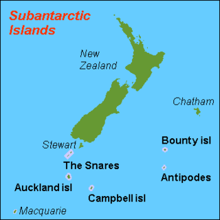
The New Zealand Subantarctic Islands comprise the five southernmost groups of the New Zealand outlying islands. They are collectively designated as a UNESCO World Heritage Site.

The Campbell Islands are a group of subantarctic islands, belonging to New Zealand. They lie about 600 km south of Stewart Island. The islands have a total area of 113 km2 (44 sq mi), consisting of one big island, Campbell Island, and several small islets, notably Dent Island, Isle de Jeanette Marie, Folly Island, Jacquemart Island, and Monowai Island. Ecologically, they are part of the Antipodes Subantarctic Islands tundra ecoregion. The islands were gazetted as a nature reserve in 1954, and are one of five subantarctic island groups collectively designated as a World Heritage Site by UNESCO.

The Subantarctic snipe is a species of snipe endemic to New Zealand's subantarctic islands. The Maori call it "Tutukiwi". The nominate race C. a. aucklandica is found on the Auckland Islands. Other subspecies include C. a. meinertzhagenae from the Antipodes Islands, and C. a. perseverance from Campbell Island / Motu Ihupuku. The former subspecies from the Snares Islands has been separated as a full species, the Snares snipe, as have the extinct South Island and North Island snipes.
The Tītī / Muttonbird Islands are an island group near Stewart Island in the far south of New Zealand. The islands are not permanently inhabited, and are named for the traditional seasonal harvesting ("muttonbirding") of the sooty shearwater by Māori. These birds are known as "muttonbirds" due to their supposedly mutton-like taste.

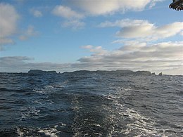
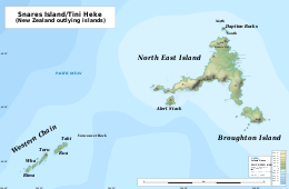
North East Island is the main island of the Snares Island group at 48°01′S166°36′E approximately 200 kilometres (120 mi) south of New Zealand's South Island. The island forms a central triangle with peninsulas to the north, south and to the west and is some 3 by 2.5 km long by wide. Off the South Promontory lies Broughton Island, the second largest island in the group. South off the western peninsula coast lies the islet Alert Stack and off the North Promontory lies the North and South Daption Rocks.

Broughton Island is the second largest island of The Snares, at 48°02′35″S166°37′15″E. It sits just off the South Promontory of the main island, North East Island, which itself lies approximately 200 kilometres (120 mi) south of New Zealand's South Island.
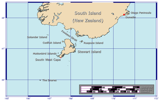
The Western Chain is a group of islets at 48°03′0″S166°30′30″E and a part of The Snares. They lie some 5 km (3.1 mi) to the WSW off the main island North East Island, which lies approx. 200 kilometres (120 mi) south of New Zealand's South Island. The Western Chain island is some 2 km (1.2 mi) long in NW direction, and the highest elevation of 44 m (144 ft) is at the southernmost Island.

The Snares snipe, also known as the Snares Island snipe, or tutukiwi in Māori, is a species of bird in the sandpiper family, Scolopacidae.

Temperate Australasia is a biogeographic region of the Earth's seas, comprising the temperate and subtropical waters of Australia and New Zealand, including both the Indian Ocean and Pacific coasts of the continent and adjacent islands.
Moutere Hauriri / Bounty Islands Marine Reserve is a marine reserve covering an area of 104,626 hectares around New Zealand's Bounty Islands. It was established in 2014 and is administered by the Department of Conservation.