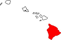
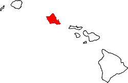
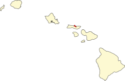
List of counties in Hawaii

Last updated

Counties of Hawaii
Location State of Hawaii
Number5
Populations81 (Kalawao) – 989,408 (Honolulu)
Areas5.2 square miles (13 km2) (Kalawao) – 4,028 square miles (10,430 km2) (Hawaii)
Government
Subdivisions

The five counties of Hawaii on the Hawaiian Islands enjoy somewhat greater status than many counties on the United States mainland. Counties in Hawaii are the only legally constituted government bodies below that of the state. No formal level of government (such as city governments) exists below that of the county in Hawaii.

Unlike the other 49 states, Hawaii does not delegate educational responsibility to local school boards; public education is carried out by the Hawaii State Department of Education. [1] Hawaiian counties collect property taxes and user fees in order to support road maintenance, community activities, parks (including life guards at beach parks), garbage collection, police (the state police force, called the Hawaii Department of Public Safety, is limited in scope), ambulance, and fire suppression services. [2]

All the counties were created in 1905 from unorganized territory, seven years after the Territory of Hawaii was created. [2] [3] The county of Kalawao was historically exclusively used as a leper colony, and does not have many of the elected officials the other counties do. [4] Many services for Kalawao County are provided by Maui County. For example, the web site for the office of the Maui County Clerk says "The office is also responsible for the elections in the County of Maui and the County of Kalawao". [5]

County information

The Federal Information Processing Standard (FIPS) code, which is used by the United States government to uniquely identify counties, is provided with each entry. The FIPS code for each county links to census data for that county.

County
FIPS code [6] County seat [7] Est. [7] EtymologyIsland(s)
Population [8] Area [8] Map
Hawai'iCounty 001 Hilo 1905 Island of Hawaiʻi, with which the county is coterminous; said to be named for Hawaiʻiloa, a legendary Polynesian navigator. Hawaiʻi 207,6154,028 sq mi
(10,432 km2)
Map of Hawaii highlighting Hawaii County.svg
Honolulu County 003 Honolulu 1905"Sheltered bay" or "place of shelter" in the Hawaiian language, [9] Named after Honolulu, the capital and largest city of the state. Oʻahu and the Northwestern Hawaiian Islands (except Midway Atoll)989,408597 sq mi
(1,546 km2)
Map of Hawaii highlighting Honolulu County.svg
KalawaoCounty 005 1905The village of Kalawao on Molokaʻi The Kalaupapa Peninsula on Molokaʻi 815.2 sq mi
(13 km2)
Map of Hawaii highlighting Kalawao County.svg
KauaiCounty 007 Lihue 1905 Kauai, the largest of the islands in the county; name possibly derived from Kauaʻi, the eldest son of Hawaiʻiloa. Kauai, Niʻihau, Lehua, and Kaʻula 73,851622 sq mi
(1,611 km2)
Map of Hawaii highlighting Kauai County.svg
MauiCounty 009 Wailuku 1905 Maui, the largest of the islands in the county; named for Māui, a demigod from native mythology. Maui, Kahoʻolawe, Lānaʻi, Molokai (except the Kalaupapa Peninsula), and Molokini 164,1831,120 sq mi
(2,901 km2)
Map of Hawaii highlighting Maui County.svg

Related Research Articles

<span class="mw-page-title-main">Kalawao County, Hawaii</span> County in Hawaii, United States

Kalawao County is a county in the U.S. state of Hawaii. It is the smallest county in the 50 states by land area and the second-smallest county by population, after Loving County, Texas. The county encompasses the Kalaupapa or Makanalua Peninsula, on the north coast of the island of Molokaʻi. The small peninsula is isolated from the rest of Molokaʻi by cliffs over a quarter-mile high; the only land access is a mule trail.

<span class="mw-page-title-main">Maui County, Hawaii</span> County in Hawaii, United States

Maui County, officially the County of Maui, is a county in the U.S. state of Hawaii. It consists of the islands of Maui, Lānaʻi, Molokaʻi, Kahoʻolawe, and Molokini. The latter two are uninhabited. As of the 2020 census, the population was 164,754. The county seat is Wailuku.

<span class="mw-page-title-main">County (United States)</span> Subdivision used by most states in the United States

In the United States, a county or county equivalent is an administrative or political subdivision of a U.S. state or other territories of the United States which consists of a geographic area with specific boundaries and usually some level of governmental authority. The term "county" is used in 48 states, while Louisiana and Alaska have functionally equivalent subdivisions called parishes and boroughs, respectively. The specific governmental powers of counties vary widely between the states, with many providing some level of services to civil townships, municipalities, and unincorporated areas. Certain municipalities are in multiple counties; New York City is uniquely partitioned into five counties, referred to at the city government level as boroughs. Some municipalities have been consolidated with their county government to form consolidated city-counties, or have been legally separated from counties altogether to form independent cities. Conversely, those counties in Connecticut, Rhode Island, eight of Massachusetts's 14 counties, and Alaska's Unorganized Borough have no government power, existing only as geographic distinctions.

In 45 of the 50 states of the United States, the county is used for the level of local government immediately below the state itself. Louisiana uses parishes, and Alaska uses boroughs. In Connecticut, Massachusetts, and Rhode Island, some or all counties within states have no governments of their own; the counties continue to exist as legal entities, however, and are used by states for some administrative functions and by the United States Census bureau for statistical analysis. There are 3,242 counties and county equivalent administrative units in total, including the District of Columbia and 100 county-equivalents in the U.S. territories.

References

  1. Hawaii State Department of Education. "Hawai'i DOE, About" . Retrieved April 26, 2007.
  2. 1 2 "Hawaii State: Facts & Figures – Des Osman Realty". Archived from the original on December 18, 2012. Retrieved April 26, 2007.
  3. Office of the County Clerk. "Foreword" (PDF). Archived from the original (PDF) on July 3, 2007. Retrieved April 26, 2007.
  4. "Hawaii's 4 (or 5) Counties". September 1, 1999. Retrieved July 23, 2007.
  5. "Office of the County Clerk" . Retrieved July 24, 2018.
  6. "EPA County FIPS Code Listing". EPA. Archived from the original on September 22, 2004. Retrieved April 9, 2007.
  7. 1 2 "Find A County". National Association of Counties. Retrieved May 11, 2013. (Find a county)
  8. 1 2 "Hawaii QuickFacts from the US Census Bureau". State & County QuickFacts. Retrieved April 20, 2024.
  9. "Honolulu Homes Guide". 2005. Archived from the original on August 9, 2007. Retrieved July 23, 2007.