List of counties in Michigan

Last updated

Counties of Michigan
Location Michigan
Number83
Populations2,172 (Keweenaw) – 1,751,169 (Wayne)
Areas508 square miles (1,320 km2) (Cass) – 5,966 square miles (15,450 km2) (Keweenaw)
Government
Subdivisions

There are 83 counties in the U.S. state of Michigan. The boundaries of these counties have not changed substantially since 1897. However, throughout the 19th century, the state legislature frequently adjusted county boundaries. County creation was intended to fulfill the goal of establishing government over unorganized territory, but a more important goal was encouraging settlement by surveying the land and dividing it into saleable sections.

Contents

The creation of counties generally occurred in two stages. First the boundaries of a county were declared and given a name. The county appeared on maps, even though this may have been the entire extent of a county's tangible existence for several years. During this period, the as-yet–unorganized county was attached to another already organized county for administrative purposes. The legislature frequently changed the administrative attachment of these unorganized counties. Residents of such an attached county could petition the legislature for organization, which was the granting of full legal recognition to the county.

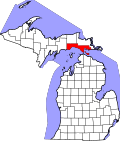
There are many cities and villages that span county boundaries in Michigan, including its capital, Lansing. For a few years during the early 1970s, split cities briefly had authority to petition to change the county boundaries to accord with the city boundaries. The only city to take advantage of this brief opportunity was New Baltimore (previously split between Macomb County and St. Clair County; now completely in Macomb). This transfer of territory from St. Clair to Macomb was the only county boundary change in Michigan since the early 20th century.

The state constitution of 1850 permitted an incorporated city with a population of at least 20,000 to be organized into a separate county of its own. [1] The Constitution of 1908 retained this provision, but raised the population threshold to 100,000. [2] No city was ever organized into an independent county in this fashion and when a new Constitution took effect in 1963, the provision was removed.

Michigan's boundary with Illinois is formed by Lake Michigan, and three counties have water boundaries with Illinois[ citation needed ]: Berrien County, Van Buren County, and Allegan County. Michigan also has a boundary with Minnesota, which is formed by Lake Superior. The water boundary in this instance is formed by two counties: Ontonagon County and Keweenaw County. The land boundary with Wisconsin continues into Lake Superior, involving both Gogebic County (which shares a land border) and Ontonagon County (water boundary only).

Etymologies

Nine counties have names invented by the ethnologist Henry Schoolcraft, usually adapted from parts of Native American words, but sometimes having parts from Greek, Arabic and Latin roots. [3] Schoolcraft's made-up words have disputed sources. While he was a devotee of Native American words and culture, some of his words may have originated with tribes from other areas of the country, such as New York or the Northeast, where many settlers to Michigan came from. Real Native words were eradicated, and he substituted made-up words, sometimes with a kernel of Indian language or sound in them. [4] [5] [6]

A second group of four counties were renamed for Irish locales (counties Antrim, Clare, Roscommon and Wexford), apparently because it was close to the heart for certain Michigan legislators or their constituents.

Ten counties, the so-called "cabinet counties", were named for persons who served in Andrew Jackson's presidential administration, which was tied to Michigan's anticipated ascendancy to statehood. Eight were named in 1829. Livingston County was named in 1833. Cass County was also named in 1829, but Governor Lewis Cass did not become a member of Jackson's Cabinet until 1831. [3] [4] [7]

The FIPS county code is the five-digit Federal Information Processing Standard (FIPS) code which uniquely identifies counties and county equivalents in the United States. The three-digit number is unique to each individual county within a state, but to be unique within the entire United States, it must be prefixed by the state code. This means that, for example, the number 001 is shared by Alcona County, Michigan, Adams County, Wisconsin, and Adair County, Iowa. To uniquely identify Alcona County, Michigan, one must use the state code of 26 plus the county code of 001; therefore, the unique nationwide identifier for Alcona County, Michigan is 26001. The links in the column FIPS County Code are to the Census Bureau Info page for that county. [8]


List of counties

County
FIPS code [8] County seat [9] Est. [9] OriginEtymologyPopulation
(2023) [10]
Area [9] Map
AlconaCounty 001 Harrisville 1840 (boundaries declared)
1869 (organized)
From unorganized territory; named Negwegon County until 1843 Schoolcraft pseudo-Native American name 10,4891,791 sq mi
(4,639 km2)
Map of Michigan highlighting Alcona County.svg
AlgerCounty 003 Munising 1885From part of Schoolcraft County Russell A. Alger, (1836-1907):
Governor and national politician
8,7575,049 sq mi
(13,077 km2)
Map of Michigan highlighting Alger County.svg
AlleganCounty 005 Allegan 1831 (boundaries declared)
1835 (organized)
From part of Barry County, and unorganized territory Schoolcraft pseudo-Native American name 121,9391,833 sq mi
(4,747 km2)
Map of Michigan highlighting Allegan County.svg
AlpenaCounty 007 Alpena 1840 (boundaries declared)
1857 (organized)
From part of Mackinac County, and unorganized territory Was named Anamickee County until 1843. Schoolcraft pseudo-Native American name 28,9041,695 sq mi
(4,390 km2)
Map of Michigan highlighting Alpena County.svg
AntrimCounty 009 Bellaire 1840 (boundaries declared)
1863 (organized)
From part of Mackinac County; named Meegisee County until 1843 County Antrim, now in Northern Ireland 24,409602 sq mi
(1,559 km2)
Map of Michigan highlighting Antrim County.svg
ArenacCounty 011 Standish 1831 (boundaries established)
1883 (organized)
From unorganized territory; annexed to Bay County in 1857, but reinstated in 1883 Schoolcraft pseudo-Native American name 15,145681 sq mi
(1,764 km2)
Map of Michigan highlighting Arenac County.svg
BaragaCounty 013 L'Anse 1875From part of Houghton County Frederic Baraga (1797-1868): Catholic missionary and first bishop of Sault Ste. Marie 8,3101,069 sq mi
(2,769 km2)
Map of Michigan highlighting Baraga County.svg
BarryCounty 015 Hastings 1829 (boundaries established)
1839 (organized)
From unorganized territory William T. Barry (1784-1835): Postmaster General in the Jackson Administration 63,808577 sq mi
(1,494 km2)
Map of Michigan highlighting Barry County.svg
BayCounty 017 Bay City 1857From parts of Arenac, Midland, and Saginaw Counties Saginaw Bay 102,500631 sq mi
(1,634 km2)
Map of Michigan highlighting Bay County.svg
BenzieCounty 019 Beulah 1863From part of Leelanau County French name of Betsie River: (rivière aux) Bec-scies, the "(river of) sawbill ducks"18,441860 sq mi
(2,227 km2)
Map of Michigan highlighting Benzie County.svg
BerrienCounty 021 St. Joseph 1829From unorganized territory John M. Berrien (1781-1856): Attorney General in the Jackson Administration 152,2611,581 sq mi
(4,095 km2)
Map of Michigan highlighting Berrien County.svg
BranchCounty 023 Coldwater 1829From unorganized territory John Branch (1782-1863): Secretary of the Navy in the Jackson Administration 45,215519 sq mi
(1,344 km2)
Map of Michigan highlighting Branch County.svg
CalhounCounty 025 Marshall 1829From unorganized territory John C. Calhoun (1782-1850): Vice President of the United States in the Jackson Administration 133,366718 sq mi
(1,860 km2)
Map of Michigan highlighting Calhoun County.svg
CassCounty 027 Cassopolis 1829From unorganized territory Lewis Cass (1782-1866): Secretary of War in the Jackson Administration 51,642508 sq mi
(1,316 km2)
Map of Michigan highlighting Cass County.svg
CharlevoixCounty 029 Charlevoix 1869From parts of Antrim, Emmet, and Otsego Counties Pierre François Xavier de Charlevoix (1682-1761): Jesuit traveller and historian of New France 26,1591,391 sq mi
(3,603 km2)
Map of Michigan highlighting Charlevoix County.svg
CheboyganCounty 031 Cheboygan 1840From part of Mackinac County Cheboygan River 26,048885 sq mi
(2,292 km2)
Map of Michigan highlighting Cheboygan County.svg
ChippewaCounty 033 Sault Ste. Marie 1827From part of Mackinac County Ojibwa Native American tribe, also known as the Chippewa36,2642,698 sq mi
(6,988 km2)
Map of Michigan highlighting Chippewa County.svg
ClareCounty 035 Harrison 1840From part of Mackinac County, and unorganized territory; named Kaykakee County until 1843 County Clare, Ireland 31,316575 sq mi
(1,489 km2)
Map of Michigan highlighting Clare County.svg
ClintonCounty 037 St. Johns 1831From unorganized territory DeWitt Clinton (1769-1828): Governor of New York.79,720575 sq mi
(1,489 km2)
Map of Michigan highlighting Clinton County.svg
CrawfordCounty 039 Grayling 1840From part of Mackinac County and unorganized territory. Was named Shawano County until 1843. William Crawford, (1732-82), American Revolutionary War colonel western surveyor13,538563 sq mi
(1,458 km2)
Map of Michigan highlighting Crawford County.svg
DeltaCounty 041 Escanaba 1843From part of Mackinac County and unorganized territory. Greek letter delta, referring to the triangular shape of the original county, which included segments of Menominee, Dickinson, Iron and Marquette counties36,7901,992 sq mi
(5,159 km2)
Map of Michigan highlighting Delta County.svg
DickinsonCounty 043 Iron Mountain 1891From parts of Iron County, Marquette County and Menominee County. Donald M. Dickinson (1846-1917): Postmaster General in the Cleveland Administration 25,982777 sq mi
(2,012 km2)
Map of Michigan highlighting Dickinson County.svg
EatonCounty 045 Charlotte 1829From unorganized territory. John Eaton (1790-1856): Secretary of War in the Jackson Administration 108,820579 sq mi
(1,500 km2)
Map of Michigan highlighting Eaton County.svg
EmmetCounty 047 Petoskey 1840From part of Mackinac County. Was named Tonegadana County until 1843. Robert Emmet (1778-1803): Irish nationalist and rebel leader34,123882 sq mi
(2,284 km2)
Map of Michigan highlighting Emmet County.svg
GeneseeCounty 049 Flint 1835From parts of Lapeer County, Saginaw County and Shiawassee County. Seneca word, "je-nis-hi-yeh," meaning "beautiful valley": named after western New York valley from which many settlers came401,522649 sq mi
(1,681 km2)
Map of Michigan highlighting Genesee County.svg
GladwinCounty 051 Gladwin 1831From unorganized territory. Major Henry Gladwin, British commander of the fort at Detroit during the siege by Chief Pontiac in 1763-64.25,853516 sq mi
(1,336 km2)
Map of Michigan highlighting Gladwin County.svg
GogebicCounty 053 Bessemer 1887From part of Ontonagon County.Probably from the Chippewa "bic" which most references interpret as "rock."14,2241,476 sq mi
(3,823 km2)
Map of Michigan highlighting Gogebic County.svg
Grand TraverseCounty 055 Traverse City 1840 (boundaries declared)
1851 (organized)
From part of Mackinac County; named Omeena County until 1851. French grande traverse [note 1] ("long crossing"), given first to Grand Traverse Bay by French voyageurs.96,421601 sq mi
(1,557 km2)
Map of Michigan highlighting Grand Traverse County.svg
GratiotCounty 057 Ithaca 1831From unorganized territory. Captain Charles Gratiot (1788-1855), built Fort Gratiot at the present site of Port Huron 41,368572 sq mi
(1,481 km2)
Map of Michigan highlighting Gratiot County.svg
HillsdaleCounty 059 Hillsdale 1829From unorganized territory.From its terrain, made up of hills and dales. [12] 45,587607 sq mi
(1,572 km2)
Map of Michigan highlighting Hillsdale County.svg
HoughtonCounty 061 Houghton 1845From parts of Marquette County and Ontonagon County. Douglass Houghton (1809-1845), first state geologist of Michigan, physician and surgeon, mayor of Detroit (1842-1843)37,5991,502 sq mi
(3,890 km2)
Map of Michigan highlighting Houghton County.svg
HuronCounty 063 Bad Axe 1840From part of Sanilac County. Lake Huron, which the French named lac des Hurons after the Hurons.30,9272,136 sq mi
(5,532 km2)
Map of Michigan highlighting Huron County.svg
InghamCounty 065 Mason 1829 (boundaries declared)
1838 (organized)
From parts of Shiawassee County, Washtenaw County and unorganized territory. Samuel D. Ingham (1779-1860), U.S. Secretary of the Treasury in the Jackson Administration 284,637561 sq mi
(1,453 km2)
Map of Michigan highlighting Ingham County.svg
IoniaCounty 067 Ionia 1831From part of Mackinac County and unorganized territory. Province in ancient Greece 66,262580 sq mi
(1,502 km2)
Map of Michigan highlighting Ionia County.svg
IoscoCounty 069 Tawas City 1840From unorganized territory. Was named Kanotin County until 1843. Schoolcraft pseudo-Native American name 25,3731,891 sq mi
(4,898 km2)
Map of Michigan highlighting Iosco County.svg
IronCounty 071 Crystal Falls 1885From parts of Marquette County and Menominee County.For the iron deposits and mines found in the county11,7401,211 sq mi
(3,136 km2)
Map of Michigan highlighting Iron County.svg
IsabellaCounty 073 Mt. Pleasant 1831From part of Mackinac County and unorganized territory. Queen Isabella I (1451-1504) of Spain, under whose patronage Columbus undertook his voyages.64,118578 sq mi
(1,497 km2)
Map of Michigan highlighting Isabella County.svg
JacksonCounty 075 Jackson 1829 (boundaries declared)
1832 (organised)
From part of Washtenaw County and unorganized territory. Andrew Jackson (1767-1845), 7th President of the United States and President when Michigan was admitted to the Union159,424724 sq mi
(1,875 km2)
Map of Michigan highlighting Jackson County.svg
KalamazooCounty 077 Kalamazoo 1829From unorganized territory.Named for the Kalamazoo River. See Etymology of Kalamazoo for a discussion of the river's name.262,215580 sq mi
(1,502 km2)
Map of Michigan highlighting Kalamazoo County.svg
KalkaskaCounty 079 Kalkaska 1840From part of Mackinac County. Was named Wabassee County until 1843. Schoolcraft pseudo-Native American name 18,490571 sq mi
(1,479 km2)
Map of Michigan highlighting Kalkaska County.svg
KentCounty 081 Grand Rapids 1831From part of Mackinac County and unorganized territory. New York jurist James Kent, who represented the Michigan Territory in its dispute with Ohio over the Toledo Strip.661,354872 sq mi
(2,258 km2)
Map of Michigan highlighting Kent County.svg
KeweenawCounty 083 Eagle River 1861From part of Houghton County. Ojibwe word gakiiwe-wewaning meaning "portage"2,1725,966 sq mi
(15,452 km2)
Map of Michigan highlighting Keweenaw County.svg
LakeCounty 085 Baldwin 1840From part of Mackinac County. Was named Aischum County until 1843.Has several small lakes and lies near Lake Michigan 12,734575 sq mi
(1,489 km2)
Map of Michigan highlighting Lake County.svg
LapeerCounty 087 Lapeer 1822From parts of Oakland County and St. Clair County.An Americanization of the French la pierre, meaning "the rock" (flint)88,977663 sq mi
(1,717 km2)
Map of Michigan highlighting Lapeer County.svg
LeelanauCounty 089 Suttons Bay Township 1840From part of Mackinac County. Schoolcraft pseudo-Native American name 23,0192,532 sq mi
(6,558 km2)
Map of Michigan highlighting Leelanau County.svg
LenaweeCounty 091 Adrian 1822From part of Monroe County.A Schoolcraft pseudo-Native American name for man, from either the Delaware leno or lenno or the Shawnee lenawai97,520761 sq mi
(1,971 km2)
Map of Michigan highlighting Lenawee County.svg
LivingstonCounty 093 Howell 1833 (boundaries declared)
1836 (organized)
From parts of Shiawassee County and Washtenaw County. Edward Livingston (1764-1836): second Secretary of State in the Andrew Jackson administration196,757585 sq mi
(1,515 km2)
Map of Michigan highlighting Livingston County.svg
LuceCounty 095 Newberry 1887From parts of Chippewa County and Mackinac County.Named for Michigan Governor Cyrus G. Luce 6,4351,912 sq mi
(4,952 km2)
Map of Michigan highlighting Luce County.svg
MackinacCounty 097 St. Ignace 1818From part of Wayne County. Was named Michilimackinac County until 1837.Originally Michilimackinac , believed to be a French interpretation of the Native American name for Mackinac Island, meaning "big turtle"10,8512,101 sq mi
(5,442 km2)
Map of Michigan highlighting Mackinac County.svg
MacombCounty 099 Mt. Clemens 1818From part of Wayne County.Named for U.S. General Alexander Macomb, a notable officer of the War of 1812 875,101570 sq mi
(1,476 km2)
Map of Michigan highlighting Macomb County.svg
ManisteeCounty 101 Manistee 1840From part of Mackinac County.Named for the Manistee River, which in turn is from the Ojibwe name, ministigweyaa meaning "(river) at whose mouth there are islands"25,5621,281 sq mi
(3,318 km2)
Map of Michigan highlighting Manistee County.svg
MarquetteCounty 103 Marquette 1843From parts of Chippewa County and Mackinac County.Named for French Jesuit missionary Jacques Marquette 66,9993,425 sq mi
(8,871 km2)
Map of Michigan highlighting Marquette County.svg
MasonCounty 105 Ludington 1840From part of Mackinac County. Was named Notipekago County until 1843.Named for Michigan Governor Stevens T. Mason 29,1591,242 sq mi
(3,217 km2)
Map of Michigan highlighting Mason County.svg
MecostaCounty 107 Big Rapids 1840From parts of Mackinac County and Oceana County.Named for Mecosta, a Native American leader41,099571 sq mi
(1,479 km2)
Map of Michigan highlighting Mecosta County.svg
MenomineeCounty 109 Menominee 1861From part of Delta County. Was named Bleeker County until 1863.Named for the Menominee Native American people22,9451,338 sq mi
(3,465 km2)
Map of Michigan highlighting Menominee County.svg
MidlandCounty 111 Midland 1831From part of Saginaw County and unorganized territory.Located near the geographical center of the Lower Peninsula 84,039528 sq mi
(1,368 km2)
Map of Michigan highlighting Midland County.svg
MissaukeeCounty 113 Lake City 1840From part of Mackinac County.Named for Missaukee, an Ottawa leader who signed land-grant treaties in 1831 and 183315,311574 sq mi
(1,487 km2)
Map of Michigan highlighting Missaukee County.svg
MonroeCounty 115 Monroe 1817From part of Wayne County.Named for James Monroe, the fifth U.S. President155,045680 sq mi
(1,761 km2)
Map of Michigan highlighting Monroe County.svg
MontcalmCounty 117 Stanton 1831From part of Mackinac County and unorganized territory.Named for Louis-Joseph de Montcalm, a French military commander in Quebec 68,154721 sq mi
(1,867 km2)
Map of Michigan highlighting Montcalm County.svg
MontmorencyCounty 119 Atlanta 1840From part of Mackinac County and unorganized territory. Was named Cheonoquet County until 1843. House of Montmorency, influential in the history of French Canada 9,678562 sq mi
(1,456 km2)
Map of Michigan highlighting Montmorency County.svg
MuskegonCounty 121 Muskegon 1859From parts of Oceana County and Ottawa County. Muskegon River running through county, from the Ojibwa/Chippewa word mashkig meaning "swamp" or "marsh."176,5641,459 sq mi
(3,779 km2)
Map of Michigan highlighting Muskegon County.svg
NewaygoCounty 123 White Cloud 1840From parts of Mackinac County and Oceana County.Named for a Chippewa leader who signed the Saginaw Treaty of 1819 [13] 51,108861 sq mi
(2,230 km2)
Map of Michigan highlighting Newaygo County.svg
OaklandCounty 125 Pontiac 1819 (boundaries declared)
1820 (organized)
From part of Macomb County.The numerous "oak openings" in the area: "majestic orchard[s] of oaks and hickories varied by small prairies, grassy lawns and clear lakes" [14] 1,270,426908 sq mi
(2,352 km2)
Map of Michigan highlighting Oakland County.svg
OceanaCounty 127 Hart 1831From part of Mackinac County.Borders Lake Michigan, the freshwater "ocean."26,9811,307 sq mi
(3,385 km2)
Map of Michigan highlighting Oceana County.svg
OgemawCounty 129 West Branch 1840From unorganized territory. Annexed to Iosco County in 1867 and reinstated in 1873.The Ojibwe word ogimaa, meaning "chief" or "leader"20,990575 sq mi
(1,489 km2)
Map of Michigan highlighting Ogemaw County.svg
OntonagonCounty 131 Ontonagon 1843 (boundaries declared)
1848 (organized)
From parts of Chippewa County and Mackinac County.Named for the Ontonagon River. The Ojibwa word onagon means "dish" or "bowl."5,9063,741 sq mi
(9,689 km2)
Map of Michigan highlighting Ontonagon County.svg
OsceolaCounty 133 Reed City 1840From part of Mackinac County. Was named Unwattin County until 1843. Osceola (1804-1838), Seminole chief23,330573 sq mi
(1,484 km2)
Map of Michigan highlighting Osceola County.svg
OscodaCounty 135 Mio 1840From part of Mackinac County and unorganized territory. Schoolcraft pseudo-Native American name 8,545572 sq mi
(1,481 km2)
Map of Michigan highlighting Oscoda County.svg
OtsegoCounty 137 Gaylord 1840From part of Mackinac County. Was named Okkudo County until 1843.Named for Otsego County, New York 25,747526 sq mi
(1,362 km2)
Map of Michigan highlighting Otsego County.svg
OttawaCounty 139 Grand Haven 1831From part of Mackinac County and unorganized territory.Named for the Native American Ottawa people.303,3721,632 sq mi
(4,227 km2)
Map of Michigan highlighting Ottawa County.svg
Presque IsleCounty 141 Rogers City 1840From part of Mackinac County.A derivation of the French phrase for "peninsula", literally "almost an island."13,2852,573 sq mi
(6,664 km2)
Map of Michigan highlighting Presque Isle County.svg
RoscommonCounty 143 Roscommon 1840From part of Mackinac County and unorganized territory. Was named Mikenauk County until 1843. County Roscommon, Ireland 23,863580 sq mi
(1,502 km2)
Map of Michigan highlighting Roscommon County.svg
SaginawCounty 145 Saginaw 1822From part of Oakland County.A Native American term, perhaps a reference to the Saginaw River and Saginaw Bay, Ojibwe for "at the outlet" [15] 187,782816 sq mi
(2,113 km2)
Map of Michigan highlighting Saginaw County.svg
St. ClairCounty 147 Port Huron 1820From part of Macomb County.Named for either Arthur St. Clair, first governor of the Northwest Territory, or Saint Clair on whose feast day Lake St. Clair was discovered159,874837 sq mi
(2,168 km2)
Map of Michigan highlighting St. Clair County.svg
St. JosephCounty 149 Centreville 1829From unorganized territory.The St. Joseph River, which flows through the county. [16] 60,878521 sq mi
(1,349 km2)
Map of Michigan highlighting Saint Joseph County.svg
SanilacCounty 151 Sandusky 1822From part of St. Clair County. Sanilac, a Wyandotte chief40,3681,590 sq mi
(4,118 km2)
Map of Michigan highlighting Sanilac County.svg
SchoolcraftCounty 153 Manistique 1843From parts of Chippewa County and Mackinac County. Henry Rowe Schoolcraft, (1793-1864):
American geographer and Superintendent of Indian Affairs in Michigan
8,1491,884 sq mi
(4,880 km2)
Map of Michigan highlighting Schoolcraft County.svg
ShiawasseeCounty 155 Corunna 1822From parts of Oakland County and St. Clair County.Named for the Shiawassee River, and means 'river that twists about. [17] 68,025541 sq mi
(1,401 km2)
Map of Michigan highlighting Shiawassee County.svg
TuscolaCounty 157 Caro 1840From part of Sanilac County. Schoolcraft pseudo-Native American name 52,826914 sq mi
(2,367 km2)
Map of Michigan highlighting Tuscola County.svg
Van BurenCounty 159 Paw Paw 1829From unorganized territory. Martin Van Buren (1782-1862): Secretary of State in the Jackson Administration, later Vice President and eighth President of the United States 75,7981,090 sq mi
(2,823 km2)
Map of Michigan highlighting Van Buren County.svg
WashtenawCounty 161 Ann Arbor 1822 (boundaries declared)
1826 (organised)
From parts of Oakland County and Wayne CountyFrom the Native American name for the Grand River, O-wash-ta-nong ("faraway water"), [18] whose headwaters were within the county's bounds.365,536723 sq mi
(1,873 km2)
Map of Michigan highlighting Washtenaw County.svg
WayneCounty 163 Detroit 1815All lands within Michigan Territory that had been ceded by Native Americans through the 1807 Treaty of Detroit. "Mad" Anthony Wayne, (1745-1796):
United States Army general and statesman
1,751,169672 sq mi
(1,740 km2)
Map of Michigan highlighting Wayne County.svg
WexfordCounty 165 Cadillac 1840From part of Mackinac County. Was named Kautawaubet County until 1843. County Wexford, Ireland 34,122576 sq mi
(1,492 km2)
Map of Michigan highlighting Wexford County.svg

Defunct counties and county precursors

This listing includes only counties or county precursors created by the Territory of Michigan or the State of Michigan. It excludes counties that existed in the Territory of Michigan or the modern boundaries of the State of Michigan but were created by any other entity (another state, a territorial government, the federal government, etc.) before the creation of the Territory of Michigan. [19]

  1. Brown County, formed on December 3, 1818, from unorganized territory when Michigan Territory was expanded to include area west of Lake Michigan upon formation of the state of Illinois. Transferred to Wisconsin Territory on July 3, 1836, and continues as Brown County, Wisconsin.
  2. Crawford County, formed on December 3, 1818, from unorganized territory when Michigan Territory was expanded to include area west of Lake Michigan upon formation of the state of Illinois. Transferred to Wisconsin Territory on July 3, 1836, and continues as Crawford County, Wisconsin.
  3. Des Moines County, formed on October 1, 1834, from unorganized territory. Transferred to Wisconsin Territory on July 3, 1836, and continues as Des Moines County, Iowa.
  4. Detroit District, formed on July 3, 1805, as a county precursor by Territorial Governor Lewis Cass to carry out the Territory's judicial and administrative functions. Superseded by counties on October 2, 1818, as proclaimed by William Woodbridge, Secretary of Michigan Territory.
  5. Dubuque County, formed on October 1, 1834, from unorganized territory. Transferred to Wisconsin Territory on July 3, 1836, and continues as Dubuque County, Iowa.
  6. Erie District, formed on July 3, 1805, as a county precursor by Territorial Governor William Hull to carry out the Territory's judicial and administrative functions. Included parts of modern-day Indiana and the Toledo Strip. Although the Erie District was officially superseded by counties by proclamation of Michigan Territorial Secretary William Woodbridge on October 2, 1818, the area of the district had actually been lost to the State of Indiana when it was created on December 11, 1816.
  7. Huron District formed on July 3, 1805, as a county precursor by Territorial Governor William Hull to carry out the Territory's judicial and administrative functions. Superseded by counties on October 2, 1818, as proclaimed by William Woodbridge, Secretary of Michigan Territory.
  8. Iowa County, formed on January 1, 1830, from part of Crawford County. Transferred to Wisconsin Territory on July 3, 1836, and continues as Iowa County, Wisconsin.
  9. Isle Royale County, formed on March 4, 1875, from part of Keweenaw County. County became officially unorganized on March 13, 1885, and was attached to Houghton County, for judicial and administrative purposes. Michigan Legislature officially dissolved Isle Royale County and returned it to Keweenaw County on April 9, 1897.
  10. Keskkauko County, formed on April 1, 1840, from part of Mackinac County. Renamed Charlevoix County, on March 8, 1843. Annexed to Emmet County, on January 29, 1853, and eliminated as a county. Reformed as Charlevoix County from Emmet, Antrim, and Otsego, Counties on April 2, 1869, albeit with boundaries that differed somewhat from the 1840–1853 iteration of Keskkauko–Charlevoix County.
  11. Manitou County, formed on February 12, 1855, from parts of Emmet County and Leelanau County. On March 16, 1861, Manitou County was attached to Mackinac County for meetings of the District Court, but all other County functions were unchanged. Four years later, on March 10, 1865, the District Court attachment was changed to Leelanau County instead of Mackinac. Another four years later, on March 24, 1869, the District Court attachment to Leelanau County was terminated. The entire Manitou County government was dissolved on April 4, 1895, and the county was abolished. It was absorbed by Charlevoix County, and Leelanau County.
  12. Michilimackinac District formed on July 3, 1805, as a county precursor by Territorial Governor William Hull to carry out the Territory's judicial and administrative functions. Incorporated into Wayne County, on October 18, 1816.
  13. Milwaukee County, formed on September 6, 1834, from part of Brown County. Transferred to Wisconsin Territory on July 3, 1836, and continues as Milwaukee County, Wisconsin.
  14. Omeena County, formed on April 1, 1840, from part of Mackinac County. Annexed to Grand Traverse County, on February 3, 1853.
  15. Wyandot County, formed on April 1, 1840, from part of Mackinac County. Annexed to Cheboygan County, on January 29, 1853.
  16. Washington County, formed in 1867 from Marquette County, but declared unconstitutional.

See also

Related Research Articles

<span class="mw-page-title-main">Leelanau County, Michigan</span> County in Michigan, United States

Leelanau County is a county located in the U.S. state of Michigan. As of the 2020 census, the population was 22,301. Since 2008, the county seat has been located within Suttons Bay Township, one mile east of the unincorporated village of Lake Leelanau. Before 2008, Leelanau County's seat was Leland. Leelanau County is included in the Traverse City metropolitan area of Northern Michigan. The largest settlement in Leelanau County by population is Greilickville, itself a suburb of Traverse City.

A minor civil division (MCD) is a term used by the United States Census Bureau for primary governmental and/or administrative divisions of a county or county-equivalent, typically a municipal government such as a city, town, or civil township. MCDs are used for statistical purposes by the Census Bureau, and do not necessarily represent the primary form of local government. They range from non-governing geographical survey areas to municipalities with weak or strong powers of self-government. Some states with large unincorporated areas give substantial powers to counties; others have smaller or larger incorporated entities with governmental powers that are smaller than the MCD level chosen by the Census.

<span class="mw-page-title-main">Michigan Territory</span> Territory of the US, 1805–1837

The Territory of Michigan was an organized incorporated territory of the United States that existed from June 30, 1805, until January 26, 1837, when the final extent of the territory was admitted to the Union as the State of Michigan. Detroit was the territorial capital.

<span class="mw-page-title-main">Wisconsin Territory</span> Territory of the US between 1836-1848

The Territory of Wisconsin was an organized and incorporated territory of the United States that existed from July 3, 1836, until May 29, 1848, when an eastern portion of the territory was admitted to the Union as the State of Wisconsin. Belmont was initially chosen as the capital of the territory. In 1837, the territorial legislature met in Burlington, just north of the Skunk River on the Mississippi, which became part of the Iowa Territory in 1838. In that year, 1838, the territorial capital of Wisconsin was moved to Madison.

The Leelanau Peninsula is a peninsula of the U.S. state of Michigan that extends about 30 miles (50 km) from the western side of the Lower Peninsula of Michigan into Lake Michigan, forming Grand Traverse Bay. It is often referred to as the "little finger" of the mitten-shaped lower peninsula. The peninsula is a tourist hotspot, especially due to the popularity of Sleeping Bear Dunes National Lakeshore, which adorns the southwestern coast of the peninsula. The peninsula is also largely agricultural, and is a production hotspot for cherries and wine.

<span class="mw-page-title-main">United States District Court for the Western District of Michigan</span> United States federal district court in Michigan

The United States District Court for the Western District of Michigan is the federal district court with jurisdiction over the western portion of the state of Michigan, including the entire Upper Peninsula and the Lower Peninsula from Lansing westward.

<span class="mw-page-title-main">Northern Michigan</span> Northern region of Michigans lower peninsula

Northern Michigan, also known as Northern Lower Michigan, is a region of the U.S. state of Michigan. A popular tourist destination, it is home to several small- to medium-sized cities, extensive state and national forests, lakes and rivers, and a large portion of Great Lakes shoreline. The region has a significant seasonal population much like other regions that depend on tourism as their main industry. Northern Lower Michigan is distinct from the more northerly Upper Peninsula and Isle Royale, which are also located in "northern" Michigan. In the northernmost 21 counties in the Lower Peninsula of Michigan, the total population of the region is 506,658 people.

Gull Island is the name of a dozen small islands in the U.S. state of Michigan.

Manitou Island may refer to:

<span class="mw-page-title-main">Manitou County, Michigan</span> Former county in Michigan

Manitou County was an insular county in the U.S. state of Michigan, consisting of Beaver Island and its surrounding islands, together with the North and South Manitou Islands and Fox Islands in Lake Michigan. The county existed from 1855 to 1895. The county seat was at St. James on Beaver Island.

<span class="mw-page-title-main">Outline of Michigan</span> Overview of and topical guide to Michigan

The following outline provides an overview of and topical guide to the U.S. state of Michigan:

The Michigan Department of Health and Human Services (MDHHS) is a principal department of state of Michigan, headquartered in Lansing, that provides public assistance, child and family welfare services, and oversees health policy and management.

<span class="mw-page-title-main">1996 United States presidential election in Michigan</span> Election in Michigan

The 1996 United States presidential election in Michigan took place on November 5, 1996. All 50 states and the District of Columbia, were part of the 1996 United States presidential election. Voters chose 18 electors to the Electoral College, which selected the president and vice president.

References

  1. Constitution of the State of Michigan, 1850, Article 10, Section 2
  2. Constitution of the State of Michigan, 1908, Article 8, Section 2
  3. 1 2 Clarke Historical Library, Central Michigan University, Bibliography by county and region, including origin of county names
  4. 1 2 Romig, Walter; Massie, Larry B (Designer) (1986). Michigan Place Names: The History of the Founding and the Naming of More Than Five Thousand Past and Present Michigan Communities. Detroit, Michigan: Wayne State University Press. ISBN   978-0-8143-1838-6.
  5. Vogel, Virgil J. (1986). Indian Names in Michigan. Ann Arbor, Michigan: University of Michigan Press. pp. 244, 8 B&W photographs & 3 maps. ISBN   978-0-472-06365-9.
  6. Powers, Perry F.; Cutler, H.G., assisting (1912). A History of Northern Michigan and its People.{{cite book}}: CS1 maint: multiple names: authors list (link) at Google books
  7. "Michigan Counties" Archived July 28, 2009, at the Wayback Machine from the Michigan Department of History, Arts and Libraries, which contains additional references at the end of the article
  8. 1 2 "EPA County FIPS Code Listing". EPA. Retrieved April 9, 2007.
  9. 1 2 3 National Association of Counties. "NACo County Explorer" . Retrieved January 10, 2024.
  10. U.S. Census Bureau. "Michigan QuickFacts" . Retrieved March 21, 2024.
  11. Centre national de ressources textuelles
  12. Dan Bisher (1999). "A Brief History of 'Hillsdale County'". Archived from the original on June 7, 2008. Retrieved November 24, 2008.
  13. "Clarke Historical Library bibliographic entry for Newaygo County". Archived from the original on June 5, 2010. Retrieved September 14, 2009.
  14. As described by Bela Hubbard, surveyor of Michigan
  15. "Clarke Historical Library bibliographic entry for Saginaw County". Archived from the original on June 5, 2010. Retrieved September 14, 2009.
  16. John Marvin. "Background History on St. Joseph County". Archived from the original on June 15, 2008. Retrieved November 24, 2008.
  17. "Clarke Historical Library bibliographic entry for Shiawassee County". Archived from the original on June 5, 2010. Retrieved September 14, 2009.
  18. Publications of the Historical Society of Grand Rapids. 1906. p. 36.
  19. Michigan: Individual County Chronologies, John H. Long, Editor, 2007, The Newberry Library, accessed February 21, 2021 Archived May 15, 2018, at the Wayback Machine
  1. In modern standard French, la grande traversée; as the sense of 'crossing' is obsolete for traverse. [11]

Further reading