St. Johns, Michigan

Last updated
St. Johns, Michigan
City of St. Johns
Clinton County MI Courthouse.JPG
Clinton County Courthouse in downtown St. Johns
Nickname(s): 
"S.J.", "Mint City (U.S.A.)", "Mint Capital of the World"
St. Johns, MI location.png
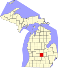
Location within Clinton County
USA Michigan location map.svg
Red pog.svg
St. Johns
Location within the state of Michigan
Usa edcp location map.svg
Red pog.svg
St. Johns
Location within the United States
Coordinates: 43°00′02″N84°33′20″W / 43.00056°N 84.55556°W / 43.00056; -84.55556 Coordinates: 43°00′02″N84°33′20″W / 43.00056°N 84.55556°W / 43.00056; -84.55556 [1]
CountryFlag of the United States.svg United States
State Flag of Michigan.svg  Michigan
County Flag of Clinton County, Michigan.svg Clinton
Settled1853
Incorporated1904
Government
  Type Commission–manager
   Mayor Eric Hufnagel
   Manager Dave Kudwa
Area
[2]
  Total4.21 sq mi (10.91 km2)
  Land4.21 sq mi (10.91 km2)
  Water0.00 sq mi (0.00 km2)
Elevation
[1]
791 ft (241 m)
Population
 (2020)
  Total7,698
  Density1,827.20/sq mi (705.45/km2)
Time zone UTC-5 (Eastern (EST))
  Summer (DST) UTC-4 (EDT)
ZIP code(s)
48879
Area code 989
FIPS code 26-70940 [3]
GNIS feature ID1627030 [1]
Website Official website

St. Johns or Saint Johns [1] is the largest city and county seat of Clinton County in the U.S. state of Michigan. [4] The population was 7,698 at the 2020 census.

Contents

St. Johns is located in the north of Clinton County, surrounded by Bingham Township (although the two are administered independently). St. Johns is about 18 miles (29 km) north of Lansing, Michigan's capital city, and is part of the Lansing–East Lansing metropolitan area. St. Johns has been nicknamed the "Mint Capital of the World". [5]

Geography

According to the United States Census Bureau, the city has a total area of 3.87 square miles (10.02 km2), all of it land. [6] The city is situated in Bingham Township, but is administratively autonomous. A mixture of rich forests, plains and farmland (uniquely, mint fields) make up the St. Johns area, providing ample opportunity for outdoor sports and agriculture.

Demographics

Historical population
CensusPop.Note
1880 2,370
1890 3,12731.9%
1900 3,3888.3%
1910 3,154−6.9%
1920 3,92524.4%
1930 3,9290.1%
1940 4,42212.5%
1950 4,95412.0%
1960 5,62913.6%
1970 6,67218.5%
1980 7,37610.6%
1990 7,284−1.2%
2000 7,4582.4%
2010 7,8655.5%
2020 7,698−2.1%
U.S. Decennial Census

2010 census

As of the census [7] of 2010, there were 7,865 people, 3,147 households, and 2,011 families residing in the city. The population density was 2,032.3 inhabitants per square mile (784.7/km2). There were 3,451 housing units at an average density of 891.7 per square mile (344.3/km2). The racial makeup of the city was 93.9% White, 1.4% African American, 0.6% Native American, 0.5% Asian, 0.1% Pacific Islander, 1.2% from other races, and 2.3% from two or more races. Hispanic or Latino of any race were 4.6% of the population.

There were 3,147 households, of which 32.8% had children under the age of 18 living with them, 45.2% were married couples living together, 14.0% had a female householder with no husband present, 4.7% had a male householder with no wife present, and 36.1% were non-families. 30.5% of all households were made up of individuals, and 13% had someone living alone who was 65 years of age or older. The average household size was 2.38 and the average family size was 2.95.

The median age in the city is 37.2. 25.4% of residents were under the age of 18; 8.5% were between the ages of 18 and 24; 26.5% were from 25 to 44; 24.1% were from 45 to 64; and 15.6% were 65 years of age or older. The gender makeup of the city was 47.7% male and 52.3% female.

Culture

The Wilson Center Auditorium on Cass Street puts on rock concerts and theatrical productions throughout the year. To date, they have brought in acts such as David Dondero, [8] Hailey Wojcik, [9] and Doug Mains and the City Folk. [10]

Mint production

Near the turn of the century, high demand for mint oil in medicines and candy from companies like Wrigley caused a surge in demand for mint farming. The rich, organic, muck soil of Clinton County makes the area around St. Johns particularly well-suited for mint farming. As a result, many mint farmers cultivated mint. [11] The Crosby Mint Farm, established by J.E. Crosby in 1912, claims to be the oldest continuously family-operated mint farm in the United States.

Today Clinton County ranks first in Michigan in regards to total mint production. [12] [13] St. Johns is known as the Mint City and has been called "The Mint Capital of the World." [14]

Each year since 1985, St. Johns celebrates its mint farming heritage with the St. Johns Mint Festival. The festival typically takes place on the second weekend in August.

Transportation

Highways

Airports

Notable people

Places of interest

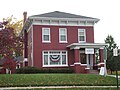
Registered Historic Buildings in St. Johns

NameImageLocationMichigan State Historic SiteMichigan Historical MarkerNational Register of Historic PlacesDescription
Coleman's Hotel Coleman Hotel Greenbush.jpg Southeast corner of US-127 and French Rd.November 21, 1975N/AN/A
Roswell C. Dexter House Roswell Dexter House St Johns.jpg 200 S. Church St.November 1, 1988N/AN/A
East Ward School106 N. Traver St.February 27, 1980N/AMay 12, 1980 [17] The East Ward School was constructed in 1876 from plans by Bay City architect Oliver Hidden. It was unusual for its size and its elaborate brickwork. In 1976 the school was named Teresa Merrill School in honor of longtime local educator Teresa A. Merrill. [18] The school building has been replaced with a housing development and a preschool.
Paine-Gillam-Scott House Paine-Gillam-Scott House St Johns.jpg 106 Maple St.January 18, 1980 [19] 1988N/ALured by the railroad, John W. Paine (1821–1870) moved from the nearby Rochester Colony to St. Johns. In 1860 he built the town's first brick store and this house. The office was later added to this site. Dr. Samuel Gillam (1845–1908) remodeled the house in 1883. In 1904 he was joined by Dr. Walter M. Scott (1875–1934), who practiced here until his death. The Clinton County Historical Society restored the house in 1978 and the office in 1986.
Henry M. Perrin-Dr. Henry Palmer House Perrin-Palmer House St Johns.jpg 903 N. Clinton Ave.February 25, 1988N/AN/A
St. John's Church St Johns Episcopal Church.jpg 400 E. Walker St.February 23, 1981 [19] 1990N/AThe congregation first organized in 1858, and built their first church in 1867. Shortly after the close of Easter evening services in 1893 the church burned. The congregation celebrated the first service in the current church on Easter Sunday 1894. [19]
St. Johns Union School Union School St Johns.jpg 205 West Baldwin St.February 27, 1980N/AMay 15, 1980 [20] The Union School was a state-of-the-art school when it was built in 1885. It served as a school for the St. Johns district until 1986. The building has been replaced with a housing development.
Steel Hotel Steelhotel.jpg West side of N. Clinton Ave.February 11, 1972N/AN/ABuilt by prominent local businessman Robert M. Steel in 1887. At the time the hotel was built, and for many years later, the building was considered one of the finest hotels in the state. The building famously burned down in 1975. [21]
Giles J. Gibbs Building Sugarbowl2013-stjohns-mi-usa48879zipcode.JPG 12 N. Clinton Ave.N/AN/AMarch 15, 2000 [22] Constructed in 1867, this building was originally home to a grocer. It is most notable for being home to the former Sugar Bowl Restaurant. The interior remains set up as a confectionery and soda fountain to this day. [23]

Sites marked with a dagger (†) have been demolished.

Climate

This climatic region is typified by large seasonal temperature differences, with warm to hot (and often humid) summers and cold (sometimes severely cold) winters. According to the Köppen Climate Classification system, St. Johns has a humid continental climate, abbreviated "Dfb" on climate maps. [24]

Climate data for St. Johns, Michigan (1991–2020 normals, extremes 1894–2016)
MonthJanFebMarAprMayJunJulAugSepOctNovDecYear
Record high °F (°C)64
(18)
69
(21)
86
(30)
89
(32)
95
(35)
100
(38)
102
(39)
102
(39)
99
(37)
89
(32)
79
(26)
69
(21)
102
(39)
Average high °F (°C)30.6
(−0.8)
33.0
(0.6)
43.7
(6.5)
56.9
(13.8)
69.3
(20.7)
78.9
(26.1)
83.2
(28.4)
81.3
(27.4)
74.8
(23.8)
61.7
(16.5)
47.3
(8.5)
36.0
(2.2)
58.1
(14.5)
Daily mean °F (°C)24.2
(−4.3)
25.8
(−3.4)
34.9
(1.6)
46.6
(8.1)
58.8
(14.9)
68.8
(20.4)
72.8
(22.7)
71.0
(21.7)
63.9
(17.7)
52.2
(11.2)
40.0
(4.4)
30.0
(−1.1)
49.1
(9.5)
Average low °F (°C)17.7
(−7.9)
18.6
(−7.4)
26.1
(−3.3)
36.4
(2.4)
48.2
(9.0)
58.7
(14.8)
62.3
(16.8)
60.7
(15.9)
53.1
(11.7)
42.6
(5.9)
32.8
(0.4)
24.1
(−4.4)
40.1
(4.5)
Record low °F (°C)−25
(−32)
−22
(−30)
−14
(−26)
5
(−15)
15
(−9)
29
(−2)
39
(4)
38
(3)
27
(−3)
14
(−10)
−5
(−21)
−14
(−26)
−25
(−32)
Average precipitation inches (mm)2.07
(53)
1.80
(46)
1.93
(49)
3.58
(91)
3.83
(97)
3.35
(85)
3.20
(81)
3.46
(88)
2.87
(73)
3.25
(83)
2.84
(72)
1.82
(46)
34.00
(864)
Average precipitation days (≥ 0.01 in)12.59.810.311.912.110.19.410.29.611.311.010.8129.0
Source: NOAA [25] [26]

Crime rate

Crime in St. Johns is significantly lower when compared to the national average, and average-to-high when compared to surrounding cities.

Violent Crime Rate in 2012 (higher number means more dangerous) [27]

Reported Incidents from 2001–2012 in St. Johns, MI: [28]

See also

Related Research Articles

<span class="mw-page-title-main">Lansing, Michigan</span> Capital city of Michigan, United States

Lansing is the capital of the U.S. state of Michigan. It is mostly in Ingham County, although portions of the city extend west into Eaton County and north into Clinton County. The 2020 census placed the city's population at 112,644, making it the sixth largest city in Michigan. The population of its metropolitan statistical area (MSA) was 541,297 at the 2020 census, the third largest in the state after metropolitan Detroit and Grand Rapids. It was named the new state capital of Michigan in 1847, ten years after Michigan became a state.

<span class="mw-page-title-main">Clinton County, Michigan</span> County in Michigan, United States

Clinton County is a county in the U.S. state of Michigan. As of the 2020 Census, the population was 79,128. The county seat is St. Johns. The county was created in 1831 and organized in 1839. It is named after early American politician DeWitt Clinton. Clinton County is included in the Lansing-East Lansing, MI Metropolitan Statistical Area.

<span class="mw-page-title-main">Ingham County, Michigan</span> County in Michigan, United States

Ingham County is a county located in the U.S. state of Michigan. As of the 2020 Census, the population was 284,900. The county seat is Mason. Lansing, the state capital of Michigan, is largely located within the county. The county is home to Michigan State University, Lansing Community College, and the Class A minor league baseball team Lansing Lugnuts. Ingham County is included in the Lansing–East Lansing, MI Metropolitan Statistical Area. It is considered to be a part of Mid Michigan.

<span class="mw-page-title-main">Eaton County, Michigan</span> County in Michigan, United States

Eaton County is a county in the U.S. state of Michigan. As of the 2020 United States Census, the population was 109,175. The county seat is Charlotte. The county was organized in 1837 and was named for John Eaton, who was Secretary of War under U.S. President Andrew Jackson, making it one of Michigan's Cabinet counties. Eaton County is included in the Lansing-East Lansing, Metropolitan Statistical area in Central Michigan.

<span class="mw-page-title-main">Munising, Michigan</span> City in Michigan, United States

Munising is a city in Alger County in the U.S. state of Michigan. The population was 2,355 at the 2010 census. It is the county seat of Alger County. The city is partially surrounded by Munising Township, but the two are administered autonomously.

<span class="mw-page-title-main">Bingham Township, Clinton County, Michigan</span> Civil township in Michigan, United States

Bingham Township is a civil township of Clinton County in the U.S. state of Michigan. As of the 2010 census, the township had a population of 2,859.

<span class="mw-page-title-main">DeWitt, Michigan</span> City in Michigan, United States

DeWitt is a city in Clinton County in the U.S. state of Michigan. The population was 4,776 at the 2020 census. The city is located north of Interstate 69 and west of U.S. Route 127, just north of the city of Lansing.

<span class="mw-page-title-main">DeWitt Charter Township, Michigan</span> Charter township in Michigan, United States

DeWitt Charter Township is a charter township of Clinton County in the U.S. state of Michigan. The population was 14,321 at the 2010 census, which was an increase from 12,143 at the 2000 census.

<span class="mw-page-title-main">Olive Township, Clinton County, Michigan</span> Civil township in Michigan, United States

Olive Township is a civil township of Clinton County in the U.S. state of Michigan. The population was 2,476 at the 2010 census.

<span class="mw-page-title-main">Charlotte, Michigan</span> City in Michigan, United States

Charlotte is a city in the U.S. state of Michigan. As of the 2010 census, the city population was 9,074. It is the county seat of Eaton County.

<span class="mw-page-title-main">Eaton Rapids, Michigan</span> City in Michigan, United States

Eaton Rapids is a city in Eaton County in the U.S. state of Michigan. The population was 5,214 at the 2010 census.

<span class="mw-page-title-main">Pellston, Michigan</span> Village in Michigan, United States

Pellston is a village in Emmet County in the U.S. state of Michigan. The population was 822 at the 2010 census. The village is the home of Pellston Regional Airport.

<span class="mw-page-title-main">Alma, Michigan</span> City in Michigan, United States

Alma is the largest city in Gratiot County in the U.S. state of Michigan. The population was 9,488 at the 2020 census. It was incorporated as the Village of Alma in 1872 and became a city in 1905.

<span class="mw-page-title-main">Haslett, Michigan</span> Census-designated place & unincorporated community in Michigan, United States

Haslett is a census-designated place (CDP) in Ingham County in the U.S. state of Michigan. It is located mostly within Meridian Charter Township with a small portion extending east into Williamstown Township. The population was 19,220 at the 2010 census. Haslett contains its own school district, as well as its own post office with the 48840 ZIP Code.

<span class="mw-page-title-main">Ionia, Michigan</span> Largest city and the county seat of Ionia County, Michigan, United States

Ionia is the largest city in, and the county seat of, Ionia County, Michigan, United States. The population was 13,378 at the 2020 census. Every July it hosts what is said to be the world's largest free-admission fair. The city is mostly within Ionia Township, with small portion extending into Easton Township and Berlin Township, but is politically autonomous of the townships.

<span class="mw-page-title-main">Mount Pleasant, Michigan</span> City in Michigan, United States

Mount Pleasant is a city in the U.S. state of Michigan. Located in Central Michigan, the city is the county seat of Isabella County. The population was 21,688 as of the 2020 United States census. It is surrounded by Union Township but is politically independent.

<span class="mw-page-title-main">Lowell, Michigan</span> City in Michigan, United States

Lowell is a city in Kent County of the U.S. state of Michigan. The population was 3,783 at the 2010 census.

<span class="mw-page-title-main">Gaylord, Michigan</span> City in Michigan, United States

Gaylord is a city in and the county seat of Otsego County in the U.S. state of Michigan. Gaylord had a population of 4,286 at the 2020 census, an increase from 3,645 at the 2010 census.

<span class="mw-page-title-main">Clare, Michigan</span> City in Michigan, United States

Clare is a city mostly in Clare County in the U.S. state of Michigan. A small portion of the city extends south into Isabella County. The population was 3,254 at the 2020 census.

<span class="mw-page-title-main">East Lansing, Michigan</span> City in Michigan, United States

East Lansing is a city in the U.S. state of Michigan. Most of the city lies within Ingham County with a smaller portion extending north into Clinton County. At the 2020 Census the population was 47,741. Located directly east of the state capital of Lansing, East Lansing is well-known as the home of Michigan State University. The city is part of the Lansing–East Lansing metropolitan area.

References

  1. 1 2 3 4 U.S. Geological Survey Geographic Names Information System: St. Johns, Michigan
  2. "2020 U.S. Gazetteer Files". United States Census Bureau. Retrieved May 21, 2022.
  3. "U.S. Census website". United States Census Bureau . Retrieved 2008-01-31.
  4. "Find a County". National Association of Counties. Retrieved 2011-06-07.
  5. Group, Sinclair Broadcast (2010-06-23). "St. Johns is mint capital of the world". WEYI. Retrieved 2023-01-16.
  6. "US Gazetteer files 2010". United States Census Bureau. Archived from the original on 2012-01-25. Retrieved 2012-11-25.
  7. "U.S. Census website". United States Census Bureau . Retrieved 2012-11-25.
  8. "Turn it down".
  9. "Group raising money to renovate Wilson Center auditorium". Lansing State Journal. 3 November 2015.
  10. "Trio of bands to play at Wilson Center".
  11. "Mint in Michigan". geo.msu.edu.
  12. History of Crosby Farm
  13. "Clinton County". Clinton county Economic Alliance. Retrieved December 15, 2017.
  14. Usealman, Kevin (June 23, 2010). "St. Johns is mint capital of the world" . Retrieved December 15, 2017.
  15. "Butterbean on fighting, handmade razors and growing up in St. Johns".
  16. 1 2 Davis, Henry Blaine Jr. (1998). Generals in Khaki. Raleigh, NC: Pentland Press. p. 343. ISBN   978-1-5719-7088-6 via Google Books.
  17. "Asset Detail". npgallery.nps.gov.
  18. "The East Ward Story, Teresa Merrill". 27 February 2015.
  19. 1 2 3 "Michigan Historical Markers". secure1.state.mi.us.
  20. "Asset Detail". npgallery.nps.gov.
  21. https://www.clinton-county.org/ArchiveCenter/ViewFile/Item/686 [ bare URL PDF ]
  22. "Asset Detail". npgallery.nps.gov.
  23. Department of the Interior. National Park Service. (3/2/1934 - ). Michigan SP Gibbs, Giles J., Building - Sugar Bowl. File Unit: National Register of Historic Places and National Historic Landmarks Program Records: Michigan, 1964 - 2013 via US National Archives Research Catalog.
  24. "St. Johns, Michigan Köppen Climate Classification (Weatherbase)". Weatherbase.
  25. "NowData - NOAA Online Weather Data". National Oceanic and Atmospheric Administration. Retrieved September 4, 2021.
  26. "Station: Saint Johns, MI". U.S. Climate Normals 2020: U.S. Monthly Climate Normals (1991-2020). National Oceanic and Atmospheric Administration. Retrieved September 4, 2021.
  27. "Rates, City-Data St. Johns, MI".
  28. "Crime Rates, City-Data St. Johns, MI".