Eureka, Michigan

Last updated

Eureka, Michigan
Eureka, Michigan (August 2021).jpg
Intersection of Maple Rapids and Welling Road
USA Michigan location map.svg
Red pog.svg
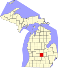
Eureka
Location within the state of Michigan
Usa edcp location map.svg
Red pog.svg
Eureka
Location within the United States
Coordinates: 43°06′13″N84°30′49″W / 43.10361°N 84.51361°W / 43.10361; -84.51361
CountryUnited States
State Michigan
County Clinton
Township Greenbush
Settled1836
Area
[1]
  Total1.01 sq mi (2.61 km2)
  Land1.01 sq mi (2.61 km2)
  Water0.00 sq mi (0.00 km2)
Elevation
[2]
725 ft (221 m)
Population
 (2020) [3]
  Total233
  Density230.69/sq mi (89.07/km2)
Time zone UTC-5 (Eastern (EST))
  Summer (DST) UTC-4 (EDT)
ZIP code(s)
48831 (Elsie)
48833
48879 (St. Johns)
Area code 989
GNIS feature ID2804347 [2]

Eureka is an unincorporated community and census-designated place (CDP) in Clinton County in the U.S. state of Michigan. [2] The population of the CDP was 233 at the 2020 census. [3] The community is located within Greenbush Township.

Contents

As an unincorporated community, Eureka has no legal autonomy of its own but does have its own post office with the 48833 ZIP Code. [4] [5]

Geography

Eureka is located in northeastern Greenbush Township in Clinton County. It is centrally located in the state's Lower Peninsula about 30 miles (48 km) north of Lansing and 40 miles (64 km) south of Mount Pleasant. [6]

U.S. Route 127 runs south–north about 3.0 miles (4.8 km) west of the community and is accessible via Maple Rapids Road. Other nearby communities include the village of Maple Rapids to the west, the village of Elsie to the east, the village of Ashley to the north, and the cities of Ovid and St. Johns to the south. Halterman Creek flows through the community. [7]

Eureka is served by St. Johns Public Schools. Eureka Elementary School is located within the community. [8] [9] The community has its own post office using the 48833 ZIP Code, although this post office is primarily used for post office box services. [4] [5] The St. Johns 48879 ZIP Code also serves the community. [10] Areas to the east of Welling Road may use the Elsie 48831 ZIP Code. [11]

History

The area was first settled in 1836 by John Ferdon. The new settlement was first known as Williamsport after early settler Clark Williams. The community was soon known as Barrington for another settler J. A. Barrington. Again, the community's name was known as Swizzletown. The community received its first post office under the name Greenbush on January 29, 1844, which was named after the township. On May 9, 1867, the post office and community were renamed Eureka, which was the name given by Edward Stark using the word eureka "as a place where he had found and others would find a fine place for doing business." [12]

The post office was discontinued on June 29, 1935. It was ultimately reestablished on September 6, 1949. The post office remains in operation and is located at 7907 North Welling Road in the center of the community. [13] [14]

The Eureka Cemetery is located on Hyde Road just south of the center of the community. [15] The cemetery remains active, and its oldest gravesite dates back to 1839.

For the 2020 census, Eureka was included as a newly listed census-designated place, which is included for statistical purposes only. Eureka continues to remain an unincorporated community with no legal autonomy of its own. [16] [17]

Demographics

Historical population
CensusPop.Note
2020 233
U.S. Decennial Census [3]

Notable people

Images

Related Research Articles

<span class="mw-page-title-main">Greenbush Township, Alcona County, Michigan</span> Civil township in Michigan, United States

Greenbush Township is a civil township of Alcona County in the U.S. state of Michigan. The population was 1,270 at the 2020 census. The population in 2021 is estimated to be 1,281.

<span class="mw-page-title-main">Mikado Township, Michigan</span> Civil township in Michigan, United States

Mikado Township is a civil township of Alcona County in the U.S. state of Michigan. The population was 850 at the 2020 census.

<span class="mw-page-title-main">Allouez Township, Michigan</span> Civil township in Michigan, United States

Allouez Township is a civil township of Keweenaw County in the U.S. state of Michigan. The population was 1,428 at the 2020 census.

<span class="mw-page-title-main">Manitou Beach–Devils Lake, Michigan</span> Census-designated place & unincorporated community in Michigan, United States

Manitou Beach–Devils Lake is a census-designated place (CDP) in Lenawee County in the U.S. state of Michigan. The population of the CDP was 2,032 at the 2020 census. It is located within Rollin Township to the south and Woodstock Township to the north.

<span class="mw-page-title-main">Garfield Township, Mackinac County, Michigan</span> Civil township in Michigan, United States

Garfield Township is a civil township of Mackinac County in the U.S. state of Michigan. The population was 1,146 at the 2010 census, and 1,166 in 2020.

<span class="mw-page-title-main">Prudenville, Michigan</span> Census-designated place & unincorporated community in Michigan, United States

Prudenville is an unincorporated community and census-designated place (CDP) in Roscommon County in the U.S. state of Michigan. The population was 1,643 at the 2020 census. Prudenville is located within Denton Township.

<span class="mw-page-title-main">Bridgeport, Michigan</span> Census-designated place & unincorporated community in Michigan, United States

Bridgeport is an unincorporated community and census-designated place (CDP) in Saginaw County in the U.S. state of Michigan. The CDP had a population of 6,571 at the 2020 census. The community is located within Bridgeport Township.

<span class="mw-page-title-main">Newport, Michigan</span> Unincorporated community in Michigan, United States

Newport is an unincorporated community in Monroe County in the U.S. state of Michigan. The community is located within Berlin Charter Township. As an unincorporated community, Newport has no legally defined boundaries or population statistics of its own but does have its own post office with the 48166 ZIP Code.

<span class="mw-page-title-main">Bay Port, Michigan</span> Census-designated place & unincorporated community in Michigan, United States

Bay Port is an unincorporated community and census-designated place (CDP) in Huron County in the U.S. state of Michigan. The population was 582 at the 2020 census. As an unincorporated community, Bay Port has no legal autonomy of its own but does have its own post office with the 48720 ZIP Code.

<span class="mw-page-title-main">Boon, Michigan</span> Census-designated place & unincorporated community in Michigan, United States

Boon is an unincorporated community and census-designated place (CDP) in Wexford County in the U.S. state of Michigan. The community is located within Boon Township. The population of the CDP was 90 at the 2020 census.

<span class="mw-page-title-main">Riverdale, Michigan</span> Census-designated place & unincorporated community in Michigan, United States

Riverdale is an unincorporated community and census-designated place (CDP) in Gratiot County in the U.S. state of Michigan. The population of the CDP was 281 at the 2020 census. The community is located within Seville Township.

<span class="mw-page-title-main">Elm Hall, Michigan</span> Census-designated place & unincorporated community in Michigan, United States

Elm Hall is an unincorporated community and census-designated place (CDP) in Gratiot County in the U.S. state of Michigan. The CDP had a population of 279 at the 2020 census. The community is located within Sumner Township.

<span class="mw-page-title-main">Pittsford, Michigan</span> Census-designated place & unincorporated community in Michigan, United States

Pittsford is an unincorporated community and census-designated place (CDP) in Hillsdale County in the U.S. state of Michigan. The population of the CDP was 553 at the 2020 census. The community is located along M-34 on the border between Jefferson Township to the west and Pittsford Township to the east.

<span class="mw-page-title-main">Winn, Michigan</span> Census-designated place & unincorporated community in Michigan, United States

Winn is an unincorporated community and census-designated place (CDP) in Isabella County in the U.S. state of Michigan. The CDP had a population of 166 at the 2020 census. The community is located within Fremont Township.

<span class="mw-page-title-main">Walloon Lake, Michigan</span> Census-designated place & unincorporated community in Michigan, United States

Walloon Lake is an unincorporated community and census-designated place (CDP) in Charlevoix County in the U.S. state of Michigan. The population of the CDP was 271 at the 2020 census. The community is located within Melrose Township.

<span class="mw-page-title-main">Ida, Michigan</span> Census-designated place & unincorporated community in Michigan, United States

Ida is an unincorporated community and census-designated place (CDP) in Monroe County in the U.S. state of Michigan. The CDP had a population of 790 at the 2020 census. The community is mostly within Ida Township with a smaller portion extending north into Raisinville Township.

<span class="mw-page-title-main">Naubinway, Michigan</span> Census-designated place & unincorporated community in Michigan, United States

Naubinway is an unincorporated community and census-designated place (CDP) in Mackinac County in the U.S. state of Michigan. The population of the CDP was 147 at the 2020 census, which was the first year that it was recorded by the census. The community is located within Garfield Township.

<span class="mw-page-title-main">Lupton, Michigan</span> Census-designated place & unincorporated community in Michigan, United States

Lupton is an unincorporated community and census-designated place (CDP) in Ogemaw County in the U.S. state of Michigan. The population of the CDP was 318 at the 2020 census. Lupton is located mostly within Rose Township with a small portion extending south into Cumming Township.

<span class="mw-page-title-main">Jasper, Michigan</span> Census-designated place & unincorporated community in Michigan, United States

Jasper is an unincorporated community and census-designated place (CDP) in Lenawee County in the U.S. state of Michigan. The CDP had a population of 371 at the 2020 census. Jasper is within Fairfield Township and has its own post office with the 49248 ZIP Code.

<span class="mw-page-title-main">Loomis, Michigan</span> Census-designated place & unincorporated community in Michigan, United States

Loomis is an unincorporated community and census-designated place (CDP) in Isabella County in the U.S. state of Michigan. The population of the CDP was 194 at the 2020 census. The community is located within Wise Township, and is also located within the Isabella Indian Reservation, home to the federally-recognized Saginaw Chippewa Tribal Nation.

References

  1. "2020 U.S. Gazetteer Files". United States Census Bureau. Retrieved May 21, 2022.
  2. 1 2 3 U.S. Geological Survey Geographic Names Information System: Eureka, Michigan
  3. 1 2 3 United States Census Bureau. "Eureka CDP, Michigan" . Retrieved February 7, 2023.
  4. 1 2 Google (August 24, 2021). "48833 ZIP Code map" (Map). Google Maps . Google. Retrieved August 24, 2021.
  5. 1 2 UnitedStatesZipCodes.org (2021). "ZIP Code 48833: Eureka" . Retrieved August 24, 2021.
  6. Michigan Economic Development Corporation (2021). "Greater Lansing Convention & Visitors Bureau: Eureka" . Retrieved August 28, 2021.
  7. U.S. Geological Survey Geographic Names Information System: Halterman Creek
  8. Michigan Geographic Framework (November 15, 2013). "Clinton County School Districts" (PDF). Retrieved August 14, 2021.
  9. U.S. Geological Survey Geographic Names Information System: Eureka School
  10. Google (August 24, 2021). "48879 ZIP Code map" (Map). Google Maps . Google. Retrieved August 24, 2021.
  11. Google (August 24, 2021). "48831 ZIP Code map" (Map). Google Maps . Google. Retrieved August 24, 2021.
  12. Romig, Walter (October 1, 1986) [1973]. Michigan Place Names: The History of the Founding and the Naming of More Than Five Thousand Past and Present Michigan Communities (Paperback). Great Lakes Books Series. Detroit, Michigan: Wayne State University Press. p. 187. ISBN   978-0-8143-1838-6.
  13. U.S. Geological Survey Geographic Names Information System: Eureka Post Office
  14. United States Postal Service (2021). "Eureka – Post Office" . Retrieved August 22, 2021.
  15. U.S. Geological Survey Geographic Names Information System: Eureka Cemetery
  16. U.S. Census Bureau (2020). "State of Michigan Census Designated Places" . Retrieved July 9, 2021.
  17. U.S. Geological Survey Geographic Names Information System: Eureka Census Designated Place
  18. Baseball Reference (2021). "Baseball Reference: LaRue Kirby" . Retrieved August 27, 2021.