Eureka Township, Michigan

Last updated
Eureka Township, Michigan
USA Michigan location map.svg
Red pog.svg
Eureka Township
Usa edcp location map.svg
Red pog.svg
Eureka Township
Coordinates: 43°9′29″N85°15′5″W / 43.15806°N 85.25139°W / 43.15806; -85.25139
Country United States
State Michigan
County Montcalm
Area
[1]
  Total29.6 sq mi (77 km2)
  Land28.7 sq mi (74 km2)
  Water0.9 sq mi (2 km2)
Elevation
801 ft (244 m)
Population
 (2020) [2]
  Total4,211
  Density146.6/sq mi (56.6/km2)
Time zone UTC-5 (Eastern (EST))
  Summer (DST) UTC-4 (EDT)
ZIP code
48838 (Greenville)
FIPS code 26-117-26520 [3]
GNIS feature ID1626251 [4]
Website eurekatownshipmi.gov

Eureka Township is a charter township of Montcalm County in the U.S. state of Michigan. The population was 4,211 at the 2020 census, [2] up from 3,959 in 2010.

Contents

The township surrounds the city of Greenville, a separate municipality, and the Greenville post office, with ZIP code 48838, serves all of Eureka Township. [5] Eureka Township was established in 1850. [6]

Geography

The township is in southern Montcalm County, bordered to the north by Montcalm Township, to the northeast by Sidney Township, to the east by Fairplain Township, to the south by Ionia County, and to the west by Kent County. The city of Greenville occupies what was originally the northern part of Eureka Township.

State highways M-57 and M-91 cross the township, intersecting in Greenville. M-57 leads east 20 miles (32 km) to Carson City and west 16 miles (26 km) to U.S. Route 131 near Edgerton, while M-91 leads south 6 miles (10 km) to its terminus near Belding and north 19 miles (31 km) to Lakeview.

According to the U.S. Census Bureau, Eureka Township has a total area of 29.6 square miles (77 km2), of which 28.7 square miles (74 km2) are land and 0.9 square miles (2.3 km2), or 2.89%, are water. [1] The township is drained by the Flat River, which flows through Greenville and across the southeast part of the township, part of the Grand River watershed. Wabasis Creek, a tributary of the Flat River, drains the southwest part of the township.

Demographics

Historical population
CensusPop.Note
1850 461
1860 988114.3%
1870 968−2.0%
1880 924−4.5%
1890 9331.0%
1900 816−12.5%
1910 746−8.6%
1920 714−4.3%
1930 7849.8%
1940 8265.4%
1950 1,02424.0%
1960 1,47043.6%
1970 1,93831.8%
1980 2,30318.8%
1990 2,59412.6%
2000 3,27126.1%
2010 3,95921.0%
2020 4,2116.4%
U.S. Decennial Census [7]

As of the census [3] of 2000, there were 3,271 people, 1,179 households, and 929 families residing in the township. The population density was 110.7 inhabitants per square mile (42.7/km2). There were 1,248 housing units at an average density of 42.2 per square mile (16.3/km2). The racial makeup of the township was 96.36% White, 0.15% African American, 0.55% Native American, 0.43% Asian, 1.35% from other races, and 1.16% from two or more races. Hispanic or Latino of any race were 3.15% of the population.

There were 1,179 households, out of which 37.4% had children under the age of 18 living with them, 68.4% were married couples living together, 6.5% had a female householder with no husband present, and 21.2% were non-families. 17.2% of all households were made up of individuals, and 5.5% had someone living alone who was 65 years of age or older. The average household size was 2.77 and the average family size was 3.09.

In the township the population was spread out, with 27.9% under the age of 18, 7.1% from 18 to 24, 29.5% from 25 to 44, 25.1% from 45 to 64, and 10.4% who were 65 years of age or older. The median age was 37 years. For every 100 females, there were 102.9 males. For every 100 females age 18 and over, there were 102.3 males.

The median income for a household in the township was $50,566, and the median income for a family was $53,380. Males had a median income of $39,919 versus $28,173 for females. The per capita income for the township was $20,223. About 3.2% of families and 5.4% of the population were below the poverty line, including 4.1% of those under age 18 and 9.6% of those age 65 or over.

Related Research Articles

<span class="mw-page-title-main">Montcalm County, Michigan</span> County in Michigan, United States

Montcalm County is a county in the U.S. state of Michigan. As of the 2020 Census, the population was 66,614. The county is geographically located in the West Michigan region of the Lower Peninsula. The county seat is Stanton, and the largest city is Greenville. The county is named for General Marquis Louis-Joseph de Montcalm, military commander of French troops during the French and Indian War. The county was set off in 1831 and organized in 1850.

<span class="mw-page-title-main">Rolland Township, Michigan</span> Civil township in Michigan, United States

Rolland Township is a civil township of Isabella County in the U.S. state of Michigan. The population was 1,210 at the 2000 census.

<span class="mw-page-title-main">Oakfield Township, Michigan</span> Civil township in Michigan, United States

Oakfield Township is a civil township of Kent County in the U.S. state of Michigan. The population was 5,782 at the 2010 census.

<span class="mw-page-title-main">Spencer Township, Michigan</span> Civil township in Michigan, United States

Spencer Township is a civil township of Kent County in the U.S. state of Michigan. The population was 3,960 at the 2010 census.

Belvidere Township is a civil township of Montcalm County in the U.S. state of Michigan. As of the 2000 census, the township population was 2,438.

Bloomer Township is a civil township of Montcalm County in the U.S. state of Michigan. As of the 2000 census, the township population was 3,039.

Bushnell Township is a civil township of Montcalm County in the U.S. state of Michigan. As of the 2000 census, the township population was 2,111.

<span class="mw-page-title-main">Carson City, Michigan</span> City in Michigan, United States

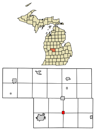
Carson City is a city in Montcalm County of the U.S. state of Michigan. The population was 1,120 at the 2020 census.

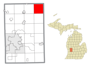
Cato Township is a civil township of Montcalm County in the U.S. state of Michigan. The population was 2,920 at the 2000 census.

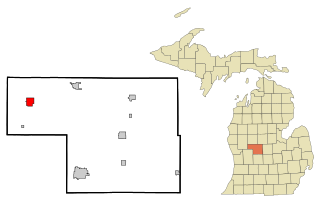
Fairplain Township is a civil township of Montcalm County in the U.S. state of Michigan. The population was 1,826 at the 2000 census.

Ferris Township is a civil township of Montcalm County in the U.S. state of Michigan. The population was 1,379 at the 2000 census.

<span class="mw-page-title-main">Greenville, Michigan</span> City in Michigan, United States

Greenville is a city in the Lower Peninsula of the U.S. state of Michigan. With a population 8,816 at the 2020 census, it is the largest city in Montcalm County. The city is the location of the establishment of the Meijer chain of stores.

<span class="mw-page-title-main">Howard City, Michigan</span> Village in Michigan, United States

Howard City is a village in Montcalm County in the U.S. state of Michigan. The population was 1,835 at the 2020 census. The village is within Reynolds Township.

<span class="mw-page-title-main">Lakeview, Michigan</span> Village in Michigan, United States

Lakeview is a village in Cato Township in Montcalm County of the U.S. state of Michigan. The population was 1,024 at the 2020 census.

Montcalm Township is a civil township of Montcalm County in the U.S. state of Michigan. The population was 3,178 at the 2000 census.

<span class="mw-page-title-main">Pierson, Michigan</span> Village in Michigan, United States

Pierson is a village in Montcalm County of the U.S. state of Michigan. The population was 229 at the 2020 census, up from 172 in 2010. The village is within Pierson Township.

<span class="mw-page-title-main">Sheridan, Michigan</span> Village in Michigan, United States

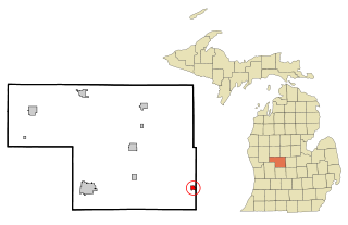
Sheridan is a village in Montcalm County in the U.S. state of Michigan. The population was 692 at the 2020 census, up from 649 in 2010. The village is located at the corners of four townships and incorporates land from each: Evergreen Township to the northeast, Bushnell Township to the southeast, Fairplain Township to the southwest, and Sidney Township to the northwest.

<span class="mw-page-title-main">Stanton, Michigan</span> City in Michigan, United States

Stanton is a city in the U.S. state of Michigan. The population was 1,348 at the 2020 census. It is the county seat of Montcalm County.

Aetna Township is a civil township of Mecosta County in the U.S. state of Michigan. As of the 2020 census, the township population was 2,241.

Evergreen Township is a civil township of Montcalm County in the U.S. state of Michigan. The population was 2,922 at the 2000 census.

References

Notes

  1. 1 2 "2023 U.S. Gazetteer Files: Michigan". United States Census Bureau. Retrieved November 16, 2023.
  2. 1 2 "P1. Race – Eureka township, Michigan: 2020 DEC Redistricting Data (PL 94-171)". U.S. Census Bureau. Retrieved November 16, 2023.
  3. 1 2 "U.S. Census website". United States Census Bureau . Retrieved 2008-01-31.
  4. U.S. Geological Survey Geographic Names Information System: Eureka Township, Michigan
  5. ZCTA Reference Map for 48838 Archived September 10, 2014, at the Wayback Machine , U.S. Census Bureau, 2000 census
  6. Romig 1986, p. 188.
  7. "Decennial Census Official Publications". U.S. Census Bureau. Retrieved November 16, 2023.

Sources