Pierson, Michigan | |
---|---|
Coordinates: 43°19′11″N85°29′52″W / 43.31972°N 85.49778°W | |
Country | United States |
State | Michigan |
County | Montcalm |
Township | Pierson |
Area | |
• Total | 0.25 sq mi (0.65 km2) |
• Land | 0.25 sq mi (0.65 km2) |
• Water | 0.00 sq mi (0.00 km2) |
Elevation | 912 ft (278 m) |
Population | |
• Total | 229 |
• Density | 919.68/sq mi (354.47/km2) |
Time zone | UTC-5 (Eastern (EST)) |
• Summer (DST) | UTC-4 (EDT) |
ZIP code | 49339 |
Area code | 616 |
FIPS code | 26-64020 [4] |
GNIS feature ID | 2399671 [2] |
Pierson is a village in Montcalm County of the U.S. state of Michigan. The population was 229 at the 2020 census, [3] up from 172 in 2010. The village is within Pierson Township.
In 1856, David S. Pierson acquired 40 acres (16 ha) of land here. With Dexter Clark and John L. Shar, Pierson founded the community while it was still part of Mecosta County. Pierson opened the first post office in his home on January 29, 1857. It was platted in 1870 and incorporated as a village in 1873. [5]
Pierson is in far western Montcalm County, in the southern part of Pierson Township. The U.S. 131 freeway passes west of the village, with access from Exit 114, 2 miles (3 km) to the northwest. Pierson is 22 miles (35 km) northwest of Greenville and 29 miles (47 km) northwest of Grand Rapids.
According to the U.S. Census Bureau, the village has a total area of 0.25 square miles (0.65 km2), all land. [1]
The Pierson post office, with ZIP code 49339, also serves most of Pierson Township, as well as portions of Maple Valley Township to the east. [6]
Census | Pop. | Note | %± |
---|---|---|---|
1880 | 372 | — | |
1890 | 215 | −42.2% | |
1900 | 215 | 0.0% | |
1910 | 183 | −14.9% | |
1920 | 164 | −10.4% | |
1930 | 144 | −12.2% | |
1940 | 147 | 2.1% | |
1950 | 169 | 15.0% | |
1960 | 219 | 29.6% | |
1970 | 193 | −11.9% | |
1980 | 216 | 11.9% | |
1990 | 207 | −4.2% | |
2000 | 185 | −10.6% | |
2010 | 172 | −7.0% | |
2020 | 229 | 33.1% | |
U.S. Decennial Census [7] |
As of the census [8] of 2010, there were 172 people, 62 households, and 45 families residing in the village. The population density was 688.0 inhabitants per square mile (265.6/km2). There were 73 housing units at an average density of 292.0 per square mile (112.7/km2). The racial makeup of the village was 98.3% White, 0.6% African American, and 1.2% from other races. Hispanic or Latino of any race were 1.7% of the population.
There were 62 households, of which 43.5% had children under the age of 18 living with them, 45.2% were married couples living together, 12.9% had a female householder with no husband present, 14.5% had a male householder with no wife present, and 27.4% were non-families. 19.4% of all households were made up of individuals, and 4.8% had someone living alone who was 65 years of age or older. The average household size was 2.77 and the average family size was 3.16.
The median age in the village was 30.3 years. 29.1% of residents were under the age of 18; 10.5% were between the ages of 18 and 24; 31.9% were from 25 to 44; 21.5% were from 45 to 64; and 7% were 65 years of age or older. The gender makeup of the village was 56.4% male and 43.6% female.
As of the census [4] of 2000, there were 185 people, 62 households, and 46 families residing in the village. The population density was 730.2 inhabitants per square mile (281.9/km2). There were 73 housing units at an average density of 288.1 per square mile (111.2/km2). The racial makeup of the village was 96.22% White, 1.62% Native American, 0.54% from other races, and 1.62% from two or more races. Hispanic or Latino of any race were 2.16% of the population.
There were 62 households, out of which 41.9% had children under the age of 18 living with them, 59.7% were married couples living together, 6.5% had a female householder with no husband present, and 24.2% were non-families. 16.1% of all households were made up of individuals, and 9.7% had someone living alone who was 65 years of age or older. The average household size was 2.98 and the average family size was 3.38.
In the village, the population was spread out, with 31.4% under the age of 18, 14.1% from 18 to 24, 32.4% from 25 to 44, 15.1% from 45 to 64, and 7.0% who were 65 years of age or older. The median age was 27 years. For every 100 females, there were 103.3 males. For every 100 females age 18 and over, there were 108.2 males.
The median income for a household in the village was $37,500, and the median income for a family was $39,000. Males had a median income of $29,063 versus $17,500 for females. The per capita income for the village was $10,456. About 8.7% of families and 11.8% of the population were below the poverty line, including 10.5% of those under the age of eighteen and 12.5% of those 65 or over.
Tri County Area Schools, which operates Tri County High School, serves Pierson. [9]
Forest Home Township is a civil township of Antrim County in the U.S. state of Michigan. The population was 1,720 at the 2010 census.
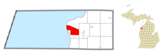
Crystal Lake Township is a civil township of Benzie County in the U.S. state of Michigan. The population was 1,065 at the 2020 census.
Sherwood is a village in Branch County of the U.S. state of Michigan. The population was 285 at the 2020 census. The village is located within Sherwood Township.
Burlington Township is a civil township of Calhoun County in the U.S. state of Michigan. It is part of the Battle Creek, Michigan Metropolitan Statistical Area. As of the 2010 census, the township population was 1,941.
Lee Township is a civil township of Calhoun County in the U.S. state of Michigan. It is part of the Battle Creek Metropolitan Statistical Area. The population was 1,213 at the 2010 census.
Bingham Township is a civil township of Huron County in the U.S. state of Michigan. As of the 2000 census, the township population was 1,751. The township is named for Kinsley S. Bingham, a U.S. Representative and U.S. Senator from and Governor of Michigan.
Rubicon Township is a civil township of Huron County in the U.S. state of Michigan. The population was 732 at the 2010 census.
Reno Township is a civil township of Iosco County in the U.S. state of Michigan. The population was 656 at the 2000 census.
Lake Isabella is a village split between Sherman Township and Broomfield Township within Isabella County in the U.S. state of Michigan. The population grew to 1,681 people as of the 2010 Census, making the community one of the state's ten fastest growing communities in terms of percentage, with an increase of 35% from the 2000 Census, and an increase of 160% from 1990. The village shares the 48893 ZIP Code with several neighboring municipalities.
Brooklyn is a village in Jackson County in the U.S. state of Michigan. The population was 1,313 at the 2020 census. It is located in the Irish Hills region of southern Michigan, just north of U.S. Route 12 along M-50. The village is located within Columbia Township.
Burlington Township is a civil township of Lapeer County in the U.S. state of Michigan. The population was 1,478 at the 2010 Census.
Martiny Township is a civil township of Mecosta County in the U.S. state of Michigan. The population was 1,594 at the 2020 census.
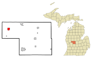
Pierson Township is a civil township of Montcalm County in the U.S. state of Michigan. The population was 3,363 at the 2020 census. The village of Pierson is located within the township.
Sherman Township is a civil township of Newaygo County in the U.S. state of Michigan. The population was 2,159 at the 2000 census.
Wilcox Township is a civil township of Newaygo County in the U.S. state of Michigan. The population was 1,145 at the 2000 census.
Newfield Township is a civil township of Oceana County in the U.S. state of Michigan. As of the 2000 census, the township had a population of 2,483.
Melvin is a village in Sanilac County in the U.S. state of Michigan. The population was 148 at the 2020 census. The village is within Speaker Township, and is located within the Thumb Region of Michigan.
Vernon is a village in Shiawassee County in the U.S. state of Michigan. The population was 783 at the 2010 census. The village is located within Vernon Township.
Decatur Township is a civil township of Van Buren County in the U.S. state of Michigan. The population was 3,916 at the 2000 census. The village of Decatur is located within the township.
Hubbardston is a village in the U.S. state of Michigan. It is mostly in North Plains Township in Ionia County, and partially in Lebanon Township in Clinton County. Its population was 395 at the 2010 census.